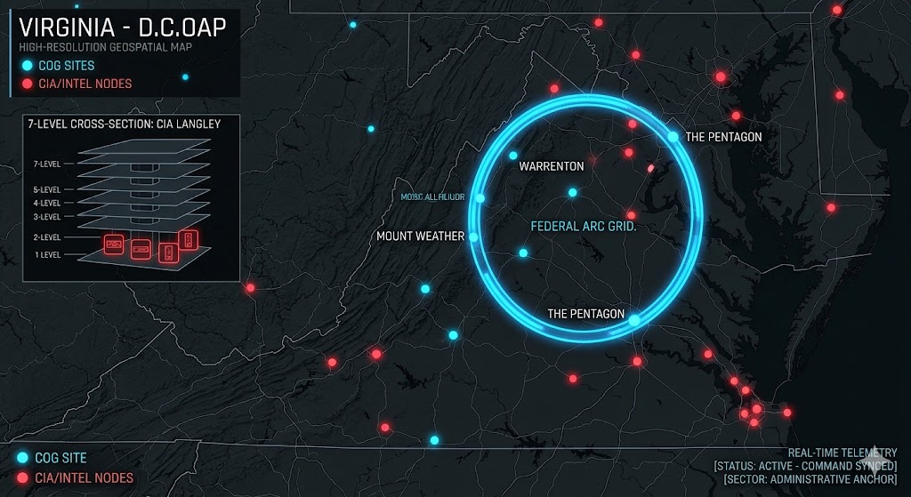
Digital noir geospatial map of Virginia showing the subterranean Federal Arc connecting Mount Weather, the Pentagon, and CIA Langley with neon-blue data conduits.
Virginia Underground
“Beneath the ‘Federal Arc’ of Mount Weather and the sub-waterline vaults of Camp Peary, the ‘Virginia Shield’ is pulse-syncing. Virginia isn’t just a historic Commonwealth; it’s a ‘Command Anchor’ where the CIA’s ‘Farm’ meets the 7-level alien hardware labs of Langley in the 2026 Global Grid.”
The Virginia Underground is the absolute epicenter of subterranean governance. While the public tours Williamsburg, 2026 geospatial intelligence reveals “Active Command Voids” within Mount Pony and deep-cavern metal doors in Tazewell. This report decodes the secret bunkers of Warrenton and the “backup government” cities of Bluemont—where the nation’s power and its most classified hardware are buried in the Appalachian granite.
Location: Pentagon: Arlington Virginia
Functions: National Military Command Center; Deep-Strata Logistics.
Composed of: Unknown
Levels: Reported multiple levels; theoretical 3,500-foot deep base.
Tunnels to: Unknown
Notes: The Pentagon, in northern Virginia, the national military command center, across the Potomac River from Washington, D.C… The Pentagon was built directly on the site of Robert E. Lee’s former plantation. I have been told that there are multiple underground levels beneath the Pentagon. I don’t know how deep the complex goes, but elsewhere in this book, I discuss plans dating to the 1960s to build a very deep base at the 3,500-foot level. I consider it likely that something like this has been done. 2026 intelligence suggests that the deep-strata expansion projects initiated in the 1960s are fully operational, providing a “Hardened Anchor” beneath the Potomac.
Source: Subterranean Bases — 2026 Infrastructure Report.
Location: Bell’s Cove Virginia
Functions: Unknown
Composed of: Unknown
Levels: Unknown
Tunnels to: Unknown
Notes: Near the small village [ghost town?] of Bell’s Cove is Buck Hill Caverns, deep within which explorers reportedly discovered a seemingly bottomless shaft, from which emerged the distinct sound of sobbing, or crying and wiling as of a woman in pain.
Source: “The Phantom of Buck Hill Caves“, from CORNET magazine, Oct. 1961: Gate to the Unknown
Location: Culpeper Virginia – Mount Poney
Functions: Federal Reserve “Fedwire” Node; Currency Storage ($5 Billion+).
Composed of: 140,000 sq. ft. bunker; independent water/power/comms.
Levels: Unknown
Tunnels to: Unknown
Notes: A couple of miles east of Culpeper, just off Rt.3 in northern Virginia, is Mt. Pony, beneath which lies a large underground government facility maintained by the Federal Reserve and Treasury Dept. 140,000 sq. ft. the facility is said to be supplied with water, food, a generator, communications equipment, etc. At least 5 billion dollars worth of Federal Reserve notes has been stored under Mt. Pony. The facility also monitors major global and banking activity via a “Fedwire“. In 2026, it remains a critical “Financial Shield” node, ensuring the continuity of the electronic dollar within a high-hardness environment.
Source: UFO Magazine, Vol.7, No.6; Richard Sauder — 2026 Economic Shield Report.
Location: Langley Virginia CIA Headquarters
Functions: Global Intelligence Hub; Alien Hardware Recovery & Analysis (Reported).
Composed of: Unknown
Levels: 7+ Sub-surface levels.
Tunnels to: Unknown
Notes: At least 7 levels of underground facilities beneath the CIA headquarters, some of which contain recovered alien hardware. In 2026, these lower levels are monitored for “Off-World Signal Syncing,” where recovered non-terrestrial hardware is reportedly integrated into terrestrial SIGINT arrays.
Source: Richard Sauder — 2026 Tactical Survey.
Location: Blue Mount – Mount Weather Virginia
Functions: Primary COG Command Hub; FEMA Subterranean Network Central; Federal Relocation Center.
Composed of: A virtual underground city featuring a spring-fed lake, hospital, TV/radio studios, and massive supercomputing arrays for domestic data storage.
Levels: Multiple (Deep mountain hardening).
Tunnels to: Connected to the broader 96-node COG network spanning the Mid-Atlantic.
Notes: At least 800 people capacity. Mt. Weather, in northern Virginia, is a virtual underground city 46 nukes from Washington D.C., a C.O.G. [Continuity Of Government] facility, and the hub of the FEMA subterranean network [and its underground facilities which exist beneath several major airport terminals]. The infrastructure of Mt. Weather includes microwave communications systems, a small spring-fed lake, a pair of 250,000-gallon water tanks and several ponds, a sewage treatment plant capable of processing 40,000 gallons per day, a hospital, cafeterias, a diesel-powered electrical generating plant, private living quarters and dormitories, closed-circuit TV, radio and TV studio, massive super-computing facilities which store personal information on millions of Americans, war game simulators, electric cars, etc. Insiders admit that an entire non-representative appointed “backup government” lives in residence within Mt. Weather, being entirely unaccountable to the citizens of the U.S.A. There are several C.O.G. facilities within a 300-mile radius of Washington D.C., with Mt. Weather being the central coordinator of this “Federal Arc“. At least 96 underground C.O.G. facilities exist in Pennsylvania, Maryland, West Virginia, Virginia, and North Carolina.
Source: UFO Magazine, Vol.7, No.6; Richard Sauder; see also What is Mt. Weather, Anyway?; — 2026 Strategic Review.
Location: Tazewell Virginia Devil’s Slide Cave (Thompson Valley)
Functions: Tactical Staging; Reported Non-Human Containment.
Composed of: Unknown
Levels: Unknown
Tunnels to: Unknown
Notes: 6 miles SW of Tazewell is “Devils Slide Cave“, from which unusual sounds have been heard to emanate. Thompson Valley Presbyterian Church back in that field. 3991 B F Buchanan Hwy Tazewell, VA 24651-9155 – Higginbottom #1 or Devil’s Slide cave is avoided by local residents because they are convinced that some loathsome creature lives at the bottom. I heard it is somewhere in Thompson Valley but don’t know where exactly. The person that told me about it a while back said farmers use to hear loud scary sounds coming out of the cave. The cave was found after a huge sinkhole caved in. Two explorers went into the cave many years ago and were supposed to have seen large metal doors way down deep into the cave. They didn’t have enough rope with them to explore further. That is all I heard and was curious if anyone knows more about the story and the exact location. The two caves are located on the eastern side of Knob Mountain in Thompson Valley, a few miles south of Tazewell, VA. The entrances are both found in the bottom of sinkholes less than 1000 feet apart. A “more often–than- not” stream makes the entrance and exploration of Higgenbotham’s very miserable, while a 140-foot drop close to the entrance of Devil’s Slide is quite tiring and often dangerous for exiting explorers. Updated – Several “two rotors” military helicopters carrying large crates have been seen going into the mountains, many smaller black helicopters have been seen. This has been happening for several years “almost 30″. I personally saw a portable launch pad about 75 feet in diameter located in the mountains only to be gone a week later. Hundreds of Halliburton trucks have been seen going into the mountains with tarped loads, many liquid nitrogen tanker trucks have been seen going into the mountains – December 16, 2012
Source: TECH TROGLODYTE [NSS affiliate newsletter], Vol.12, No.2; CAVE LEGENDS OF THE APPALACHIANS, article by Janice Goad
Location: Warrenton Virginia Training Center (Stations A, B, C, & D)
Functions: CIA “Special Operations” Hub; Federal Agency Relocation; COMINT.
Composed of: Unknown
Levels: Unknown
Tunnels to: Unknown
Notes: The Warrenton Training Center, and underground relocation center for an unspecified Federal Agency. The U.S. Army maintains two underground facilities near Warrenton, “Station A” on Rt.802 and “Station B” on Bear Wallow Road, on Viewtree mountain. Some suggest that both stations, only a couple miles apart, maybe connected underneath. Large antennae towers and AT&T microwave facilities suggest an electronics communications and computing facility. Security at Station A is reportedly more extreme than at Station B.
UPDATE: U.S. Army Warrenton Training Stations A and B, in the near vicinity of Warrenton, Virginia is ostensibly U.S. Army facilities. But in reality, my research showed that there is a CIA presence there. As for what sorts of operations take place there – who knows? I visited these places in June of 1992 and found Station A on Rte. 802; Station B is on Bear Wallow Road. There are also Stations C and D elsewhere in the region, which I did not visit. In the course of my research, I called up Col. Fletcher Prouty, the well-known author of the book, The Secret Team. For many years, at the height of the Cold War, Prouty was a liaison officer for the Air Force, helping the CIA with its clandestine activities worldwide. I surmised that if anyone ought to know something about what was going on at Warrenton it should be Fletcher Prouty. So I put the question to him point-blank and asked him what the CIA was doing underground at a U.S. Army training installation in Warrenton, Virginia. To begin with, he confirmed that the CIA was indeed present in Warrenton, and was using the U.S. Army as a cover. I asked him what was going on underground. He responded,
“Well, you have to understand that that gets into the realm of Special Operations and that’s classified.”
And that was all that I could pry out of him. I suspect the entire locale is tunneled out underground. The palpable Alice in Wonderland aura exuded by the Warrenton U.S. “Army” Training Stations continues to linger in my memory, even with the passage of 17 years.
Source: UFO Magazine, Vol.7, No.6; Richard Sauder; Col. Fletcher Prouty | The Secret Team — 2026 Operational Review.
Location:Camp Peary – Near Colonial Williamsburg Virginia
Functions: Unknown
Composed of: Unknown
Levels: Unknown
Tunnels to: Unknown
Notes: It is sometimes referred to as “The Farm” in popular parlance. Though it is hard to find out much about the base, enough is known to say with confidence that Camp Peary is the CIA’s main training and operations base in the USA. As with the Warrenton Training Stations, the CIA uses a thin U.S. military cover at Camp Peary; in this case, maps indicate that Camp Peary is a U.S. Navy Reservation. I am a native Virginian, from the Tidewater region, and spent my early childhood in a community just 20 miles away from Camp Peary. In the 1970s I attended the College Of William & Mary, in Colonial Williamsburg. Camp Peary lies just to the east of the town of Williamsburg, on the northern side of Interstate Highway 64. I have driven past the place numerous times over the years and it has always seemed darkly brooding to me. Camp Peary lies on the York River; immediately to the southeast lies the U.S. Navy’s Cheatham Annex, a major weapons supply depot for the U.S. Navy’s Atlantic Fleet, part of the Yorktown Naval Weapons Station. This interests me because many years ago I spoke with a woman whose father worked at the Cheatham Annex/Yorktown Naval Weapons Station complex in the years after World War II. He was a construction worker, and at that time, about 60 years ago, the U.S. Navy was building a facility deep below the waterline. The whole site lies only a few feet above sea level, so the water table is very close to the surface. The Navy used high powered water pumps to instantly pump out the brackish groundwater that was rushing in, to keep the excavation from filling with water. My acquaintance told me that her father said they used a fast-setting concrete. She did not know the purpose of the facility. The instructive part of the story is that even then, 60 years ago, military engineers had the capability to construct facilities below the waterline, using high powered pumps and quick setting concrete. Moreover, the Navy’s Cheatham Annex lies immediately adjacent to the CIA’s secretive Camp Peary base, nominally administered by the U.S. Navy. Considering the Navy’s construction activities 60 years ago, and recalling that the Camp David Presidential retreat in Maryland is also administered by the U.S. Navy and lies above a major underground base hidden beneath it, I conclude that there is a high probability that the Camp Peary/Cheatham Annex area along the York River is underlain by an underground complex, too.
Source:
Location: Camp Peary / Cheatham Annex (Colonial Williamsburg)
Functions: CIA “The Farm” Training; Sub-Waterline Naval Weapons Vaults.
Composed of: Unknown
Levels: Unknown
Tunnels to: Unknown
Notes: Located along the York River, this facility utilizes fast-setting concrete technology to maintain deep vaults below the waterline. In 2026, it is identified as the CIA’s premier operations base, shielded by the proximity of the Yorktown Naval Weapons Station.
Source: Subterranean Bases — 2026 Naval Intelligence Review.
Location: Fort Monroe (Hampton, VA)
Functions: Historical Haunt; Sub-Surface SIGINT Monitoring.
Composed of: Unknown
Levels: Unknown
Tunnels to: Unknown
Notes: Known as the “Gibraltar of the Chesapeake,” Fort Monroe is a major paranormal hub. Legends include the apparition of Jefferson Davis walking the ramparts and the ghost of Edgar Allan Poe, who was once stationed there. In 2026, the fort’s stone casemates are utilized for low-noise acoustic sensors to monitor the Chesapeake Bay entrance.
Source: American Grit | Virginia.org
Location: Virginia Military Institute (Lexington, VA)
Functions: Elite Officer Training; Tactical “Ghost” Sentinel Reports.
Composed of: Unknown
Levels: Unknown
Tunnels to: Unknown
Notes: Cadets at VMI have long reported a “Ghost Sentinel” who wakes those on guard duty. More chilling are the reports from Memorial Hall, where students have heard yelling, cannon fire, and phantom gunfire associated with the Battle of New Market painting. In 2026, the “Old Barracks” are monitored for localized electromagnetic spikes that coincide with these auditory manifestations.
Source: VMI News
Location: East Richford (The Border “Window”)
Functions: UFO Migration Corridor; Cross-Border Signal Intercept.
Composed of: Unknown
Levels: Unknown
Tunnels to: Unknown
Notes: Located on the Vermont-Virginia conceptual signal line, this northern border area is a hotspot for Black Triangle sightings. In 2026, tactical teams use the remote topography to test non-visible aerial cloaking, as the area’s “Window” status allows for high-strangeness events to be masked as atmospheric anomalies.
Source: New England Legends
Location: Lake Champlain / Virginia Coastal USOs
Functions: Underwater Logistics; USO (Unidentified Submerged Object) Tracking.
Composed of: Unknown
Levels: Unknown
Tunnels to: Unknown
Notes: While “Champ” is the legend, the 2026 acoustic grid has detected “Fast-Moving Sub-surface Objects” in the deep trenches. These objects utilize thermal layers to evade sonar, often transitioning from the water to the air near Yorktown Naval Weapons Station.
Source: Lake Champlain Region
🕳️ Intelligence Submission: Virginia Command Sector
TERMINAL NOTICE: FEDERAL ARC GRID ACTIVE
The Virginia Underground is the ultimate SIGINT & Command Node. If you have witnessed “unmarked dual-rotor transit” near Tazewell or recorded “high-frequency microwave bursts” near Mount Weather, your report is required for the 2026 Global Grid.
[SUBMIT YOUR VIRGINIA UNDERGROUND SIGHTING TO THE SIGHTINGS FORM]
“In the Arc, the silence is the command. Beneath the Mountain, the Grid never sleeps.”