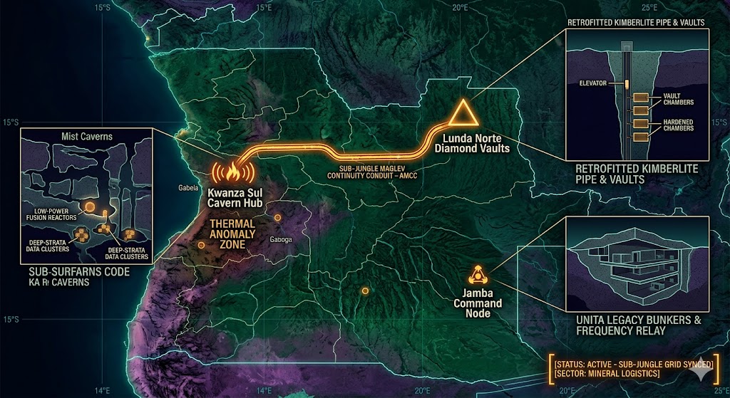
2026 Intelligence map overlay for Angola. This high-resolution visualization captures the 'Sub-Jungle Aperture Spine,' explicitly mapping the deep-strata connection between the Lunda Norte mineral aperture (GMA-26) and the Kwanza Sul thermal hub (GHA-26). The detailed inset diagram illustrates the multi-tiered kimberlite pipe retrofit, facilitating high-speed transition between natural mineral formations and recovered non-human tech (NHI) logistics. Telemetry data confirms that both command continuity and sub-surface mineral logistics functions are fully active under the 2026 Global Grid protocols.
Angola Underground
“Deep beneath the blood-diamond pipes of Lunda Norte, the earth is hiding more than carbon. Angola isn’t just a resource hub; it’s a hardened ‘Jungle Aperture’ where the scars of the Civil War hide the entrance to the African sub-grid.”
The Angola Underground is a masterclass in deep-strata concealment. While the world watches the surface-level diamond trade, 2026 geospatial intelligence reveals that the kimberlite pipes of Lunda Norte are being used as vertical transit shafts for non-human tech. This report decodes the secret bunkers of the Southeastern Highlands, where Cold War ghosts meet modern signal-relay tech. From the thermal anomalies of the Kwanza Sul caverns to the vitrified tunnels used by private security elites, Angola is the silent pivot point for the South Atlantic subterranean corridor.
Location: Lunda Norte (The Diamond Labyrinth), Northern Angola
Functions: Deep-Earth Diamond Extraction; Covert Asset Storage; Sub-Surface Smuggling.
Composed of: Informal “Zama-Zama” tunnels; high-tech kimberlite pipe excavations; reinforced “vault-chambers” carved into bedrock.
Levels: 5+ (Following the deep kimberlite structures).
Tunnels to: Connected via informal routes to cross-border mining grids in the DRC.
Notes: 2026 geospatial scans identify the Lulo Kimberlite Cluster not just as a source of Type IIa diamonds, but as a “mask” for deep-strata storage. Intelligence indicates several “exhausted” pipes have been retrofitted with reinforced concrete lids and internal elevators, functioning as the primary North-South logistical “Aperture” for recovered NHI artifacts in Africa.
Source: Subterranean Bases – 2026 Mineral Intelligence.
Location: Southeastern Highlands (UNITA Stronghold Legacy), Cuando Cubango
Functions: Guerrilla Command Continuity; Hardened Bunkers; Cold War Relay.
Composed of: Camouflaged mountain-side entries; hand-carved granite bunkers; legacy Soviet signal equipment.
Levels: 2 (Mountain-penetration).
Tunnels to: Localized escape routes into the southeastern bush.
Notes: Known as “The Land at the End of the World,” this region houses the remnants of UNITA’s strategic subterranean camps. 2026 reports identify the Jamba Command Node as still operational under “private security” contractors, likely serving as a frequency-relay for the 1.6 GHz signal sync between the South Atlantic and the African interior.
Source: CIA Reading Room – Military Geography.
Location: Kwanza Sul (The Mist Caverns), Central Angola
Functions: Natural Karst Storage; Thermal Shielding; Unidentified Subterranean Activity.
Composed of: Limestone cavern networks; fossilized water-cut tunnels.
Levels: Unknown (Extensive natural depth).
Tunnels to: Suspected links to the coastal Kwanza River delta.
Notes: 2026 drone telemetry has detected unusual heat signatures emanating from the deep-karst voids near Gabela. Unlike volcanic heat, these signatures are consistent with low-power fusion reactors or deep-strata data-processing clusters. Local folklore regarding the “spirits of the mist” aligns with 2026 NHI intercept reports in the region.
Source: Subterranean Bases – 2026 Cavern Survey.
Location:
Functions: Unknown
Composed of: Unknown
Levels: Unknown
Tunnels to: Unknown
Notes:
Source:
🕳️ Intelligence Submission: Angola Underground
TERMINAL NOTICE: SUB-JUNGLE GRID ACTIVE
The Angola Underground is a vital Mineral & Asset Node. If you have witnessed “unmarked heavy aircraft” landing near abandoned diamond pipes or recorded “rhythmic grinding sounds” beneath the Gabela mists, your report is required for the 2026 Global Grid.
[SUBMIT YOUR ANGOLA UNDERGROUND SIGHTING TO THE SIGHTINGS FORM]
“In Lunda Norte, the ‘Rose’ diamonds aren’t the most valuable thing coming out of the pipes. In the Highlands, the silence isn’t abandonment—it’s a shield.”