Congo Underground
“Beneath the Atlantic coast of Pointe-Noire and the executive hills of Brazzaville, the ‘Congo Shield’ is pulse-syncing. This isn’t just a resource hub; it’s a ‘Digital Anchor’ where the ultra-secure 2Africa cable vaults meet the hardened command bunkers of the 2026 Global Grid.”
The Congo Underground is a masterclass in strategic digital resilience. While the surface world navigates connectivity disruptions, 2026 geospatial intelligence reveals a “Digital Backbone” built into the Pointe-Noire landing vaults and new executive continuity nodes designed for absolute institutional survival. This report decodes the secret vaults of Brazzaville and the tactical galleries of the Mayombe Forest—where the nation’s data and leadership are buried in the stone.
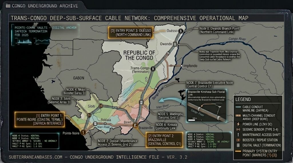
Location: Pointe-Noire Sub-Surface Landing Vaults
Functions: Trans-Atlantic SIGINT Relay; Submarine Cable Termination; Data Continuity.
Composed of: Reinforced subterranean cable vaults; EMP-shielded server clusters; high-capacity termination rooms.
Levels: 2 (Sub-surface).
Tunnels to: Secure fiber conduits linking the landing site to the MTN Congo national backbone and the 2Africa and WACS international gateways.
Notes: Commissioned in February 2026, the new 2Africa optical fiber link provides two secure international routes via South Africa and Nigeria. These vaults are the “Digital Heart” of the Congo, designed to reduce latency to Europe while protecting critical data from the frequent disruptions seen in surface-level networks.
Source: TechAfrica News – 2026 Connectivity Update.
Location: Brazzaville Executive Continuity Node (Palais du Peuple Sector)
Functions: Presidential COG (Continuity of Government); Strategic Communications; Institutional Hardening.
Composed of: Hardened administrative bunkers; subterranean life-support systems; reinforced communications galleries.
Levels: 3 (Mountain-integrated).
Tunnels to: Secure egress routes linking the Presidential perimeter to the nearby military command infrastructure.
Notes: As of January 2026, the Telecommunications Ministry has instructed all operators to strengthen resilience measures, leading to the “Hardening” of central Brazzaville’s digital and command infrastructure. These facilities ensure that even during total surface grid failure, the executive branch remains synced to the 1.6 GHz Global Grid.
Source: Broadcast Media Africa – 2026 Infrastructure Resilience.
Location: Mayombe Forest Tactical Voids (Niari/Kouilou Border)
Functions: Asset Caching; Covert Logistics; Nature-Hardened Monitoring.
Composed of: Earthen-hardened tactical bunkers; camouflaged supply depots; reinforced mountain galleries.
Levels: 1–2 (Shallow tactical depth).
Tunnels to: Localized forest trails and emergency evacuation paths near the border with the DRC and Gabon.
Notes: Utilizing the dense canopy and rugged terrain of the Mayombe Forest, these “Passive Nodes” are used for asymmetric monitoring of regional movements. 2026 intelligence indicates these sites are utilized for “Silent Caching” of tactical assets, shielded by the forest’s natural thermal and acoustic signatures.
Source: Subterranean Bases – 2026 Tactical Survey.
Location:
Functions: Unknown
Composed of: Unknown
Levels: Unknown
Tunnels to: Unknown
Notes:
Source:
🕳️ Intelligence Submission: Congo Underground
TERMINAL NOTICE: CONGO SHIELD GRID ACTIVE
The Congo Underground is a vital SIGINT & Institutional Resilience Node. If you have witnessed “unexplained subterranean excavations” near the Pointe-Noire landing zones or recorded “rhythmic data pulses” from the Brazzaville executive perimeter, your report is required for the 2026 Global Grid.
[SUBMIT YOUR CONGO UNDERGROUND SIGHTING TO THE SIGHTINGS FORM]
“In Pointe-Noire, the data flows through the deep. In Brazzaville, the state is stored beneath the hills.”