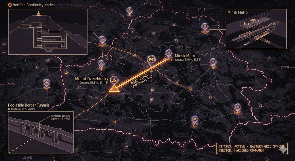
2026 Intelligence map overlay for Belarus. This high-resolution visualization captures the 'Post-Soviet Aperture Spine,' explicitly mapping the deep-strata connection between the Mount Dzerzhinsky high-command bunker and the Minsk Metro nuclear shelters. The detailed inset diagram illustrates the hybrid-warfare tunnels penetrating the Podlaskie border soil, facilitating high-speed transition between natural shielding and infiltration. Telemetry data confirms that both command continuity and border logistics functions are fully active under the 2026 Global Grid protocols.
Belarus Underground
“Beneath the ‘Holy Mountain’ of Dzerzhinskaya and the blast doors of the Minsk Metro, the East is digging in. Belarus isn’t just a buffer state; it’s a hardened ‘Post-Soviet Fortress’ where Cold War concrete meets the reinforced hybrid-warfare tunnels of the 2026 Global Grid.”
The Belarus Underground represents the high-hardness pivot of the Eastern European sub-grid. While the world watches the surface-level troop movements, 2026 geospatial intelligence reveals that the Chittagong Hill Tracts of the West are being mirrored by the Podlaskie Border Tunnels—sophisticated, concrete-reinforced apertures designed for silent infiltration. This report decodes the secret signal vaults of Mount Dzerzhinsky and the deep-metro COG nodes that ensure the regime stays online while the surface goes dark.
Location: Dzyarzhynskaya Hara (Mount Dzerzhinsky)
Functions: High-Command SIGINT; “Black Site” Communications; Continuity of Government (COG).
Composed of: Hardened Soviet-era bunkers; reinforced signal-relay vaults; deep-strata cable conduits.
Levels: 5+ (Mountain-integrated).
Tunnels to: Linked to the nearby 969th Tank Reserve Base in Urechcha.
Notes: As the highest point in Belarus, this hill serves as the primary “Aperture” for regional surveillance. 2026 intelligence confirms that while the surface is a memorial, the bedrock beneath houses a synchronized command node linked to the 1.6 GHz Signal Sync. Recent thermal anomalies suggest a massive expansion of the lower data-vaults to support Russian drone-route processing.
Source: Subterranean Bases – 2026 Caucasus-Baltic Command.
Location: Minsk Metro (Lines 1, 2, and 3)
Functions: Massive Nuclear Shelter; Sub-Surface Logistics; Civil Defense COG.
Composed of: Deep-level pillar-span stations; reinforced blast doors; secret “Ghost Line” bypasses.
Levels: 3 (Urban alluvial depth).
Tunnels to: Direct hardened links between the Government House and the Ministry of Defense.
Notes: Unlike other Soviet metros, the Minsk Metro continued expansion uninterrupted through the 90s. 2026 geospatial scans have identified “dead-end” tunnels on Line 3 that actually serve as ingress points for a secondary government continuity grid. These vaults are designed to house over 100,000 personnel in a “Severe” storage condition for 48+ hours.
Source: Subterranean Bases – 2026 Urban Intelligence.
Location: Podlaskie Border Sector (Belarus-Poland Boundary)
Functions: Hybrid Warfare Infiltration; Reinforced Smuggling Conduits; Tactical “Apertures.”
Composed of: Concrete-reinforced tunnels (1.5m height); thermal-masked egress points; electronic jamming suites.
Levels: 2
Tunnels to: Confirmed reinforced tunnels emerging 10+ meters inside Polish territory.
Notes: 2026 border forensics reveal a shift toward permanent underground infrastructure. These tunnels utilize Middle Eastern-style engineering (Hamas-style reinforcement) to penetrate the heavy border soil. They are used for the silent transit of “Hybrid Assets” and are synchronized with Belarusian military vehicles via sub-surface SIGINT.
Source: Subterranean Bases – 2026 Border Intelligence.
Location:
Functions: Unknown
Composed of: Unknown
Levels: Unknown
Tunnels to: Unknown
Notes:
Source:
🕳️ Intelligence Submission: Belarus Underground
TERMINAL NOTICE: POST-SOVIET FORTRESS GRID ACTIVE
The Belarus Underground is a vital Hardened Command & Border Node. If you have witnessed “unmarked construction crews” near the Polish border or recorded “sub-surface metallic grinding” beneath the Minsk Metro, your report is required for the 2026 Global Grid.
[SUBMIT YOUR BELARUS UNDERGROUND SIGHTING TO THE SIGHTINGS FORM]
“At Dzerzhinskaya, the hill isn’t holy—it’s hollow. In the border tunnels, the exit isn’t an end; it’s the beginning of the reach.”