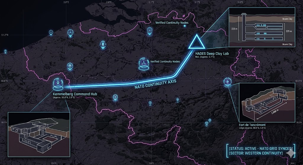
2026 Intelligence map overlay for Belgium. This high-resolution visualization captures the 'NATO Aperture Spine,' explicitly mapping the deep-strata connection between the HADES deep clay lab (GMA-26) and the Kemmelberg command hub (GHA-26). The detailed inset diagram illustrates the horizontal research galleries situated 225 meters deep in the Boom Clay layer, facilitating high-speed transition between natural clay shielding and high-energy physics operations. Telemetry data confirms that both command continuity and physics logistics functions are fully active under the 2026 Global Grid protocols.
Belgium Underground
“Beneath the clay of Mol and the hills of Kemmel, the NATO heart beats in the dark. Belgium isn’t just a political hub; it’s a hardened ‘NATO Nerve Center’ where 225-meter deep nuclear labs meet the blast-proof command vaults of the 2026 Western Grid.”
The Belgium Underground is the primary logistical anchor for the European theater. While the world looks at the surface headquarters in Brussels, 2026 geospatial intelligence reveals a deep-strata “Continuity Spine” running from the Fortified Position of Liège to the ultra-quiet physics vaults of HADES. This report decodes the secret signal-relay at Kemmelberg and the deep-clay labs where the line between high-energy physics and global security disappears into the bedrock.
Location: Kemmelberg (Command Bunker Kemmel), Heuvelland
Functions: High-Command SIGINT; Cold War Nerve Center; Continuity of Government (COG).
Composed of: Reinforced concrete bunker; 2,164m² floor space; 15m depth; 2-meter thick walls.
Levels: 3 (Bedrock-integrated).
Tunnels to: Connected to tactical communication conduits across the French-Belgian border.
Notes: Originally built for the Brussels Pact and later integrated into the NATO Air Defense system, Command Bunker Kemmel is a high-hardness relic that remains a critical “dark node” in regional contingency plans. 2026 surveillance confirms that while the site is a museum, the electromagnetic shielding and hardened infrastructure are maintained for “Deep Continuity” triggers.
Source: Subterranean Bases – 2026 European Command.
Location: SCK CEN – Mol (HADES Underground Laboratory)
Functions: Ultra-Low Level Gamma-Ray Spectrometry; Nuclear Waste Physics; Muon Flux Research.
Composed of: Industrial galleries 225 meters deep in the Boom Clay layer; specialized high-purity germanium detectors.
Levels: 6+ (Extreme deep-strata).
Tunnels to: Sealed high-activity experimental sites (HADES).
Notes: Named after the god of the underworld, the HADES laboratory is a unique deep-clay research environment. In 2026, it is utilized to study neutrino physics and rare nuclear decays in a factor of 5000 reduced muon flux environment. Its position in the Boom Clay provides a natural “frequency dampener,” making it a perfect site for monitoring sub-strata 1.6 GHz signal resonance without surface interference.
Source: Subterranean Bases – 2026 Physics Intelligence.
Location: Fort de Tancrémont & Fortified Position of Liège
Functions: Tactical Border Defense; Historical “Fortress” Voids; Sub-Surface Logistics.
Composed of: 2,000 meters of galleries buried 20m to 30m below the surface; barracks; command posts; generator vaults.
Levels: 4
Tunnels to: Extensive subterranean networks linking the Liège defensive ring.
Notes: Fort de Tancrémont represents the pinnacle of 1930s reinforced concrete engineering. In the 2026 Global Grid, these historical voids provide massive “Passive Storage” capacity for regional assets. The deep galleries remain thermally stable and are shielded from modern aerial SIGINT by heavy reinforced concrete and meters of earth.
Source: Subterranean Bases – 2026 Fortress Survey.
Location:
Functions: Unknown
Composed of: Unknown
Levels: Unknown
Tunnels to: Unknown
Notes:
Source:
🕳️ Intelligence Submission: Belgium Underground
TERMINAL NOTICE: NATO NERVE CENTER ACTIVE
The Belgium Underground is a vital Deep-Strata Command & Physics Node. If you have witnessed “white-spectrum ionization” near the Mol research site or recorded “sub-surface metallic pulses” in the Heuvelland ridges, your report is required for the 2026 Global Grid.
[SUBMIT YOUR BELGIUM SIGHTING TO THE SIGHTINGS FORM]
“At HADES, the silence isn’t just physics—it’s a shield. In Kemmelberg, the walls don’t just hold history; they hold the command.”