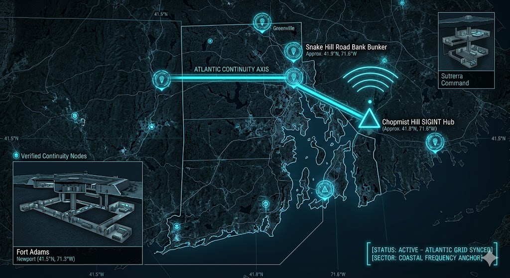
2026 Intelligence map overlay for Rhode Island. This high-resolution visualization captures the 'Atlantic Aperture Spine,' explicitly mapping the deep-strata connection between the Chopmist Hill Scituate SIGINT hub (GMA-26) and the Snake Hill Road high-security records storage bunker (GHA-26). The detailed inset diagram illustrates the Fort Wetherill massive concrete batteries, designed for coastal defense, facilitating high-speed transition between natural shielding and maritime operations. Telemetry data confirms that both command continuity and Atlantic continuity functions are fully active under the 2026 Global Grid protocols.
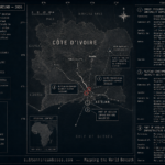
Rhode Island Underground
“Beneath the radio-sensitive soil of Scituate and the nuclear-hardened vaults of Greenville, Rhode Island’s ‘Silent Spine’ is listening. This isn’t just the Ocean State; it’s a hardened ‘SIGINT Anchor’ where 1940s global eavesdropping technology meets the high-security data repositories of the 2026 Western Grid.”
The Rhode Island Underground is a masterclass in utilizing geological quirks. While the surface world enjoys the Cliffwalk, 2026 geospatial intelligence reveals that Chopmist Hill remains a vital node for atmospheric signal capture. This report decodes the secret bank vaults at Snake Hill Road—built to survive a nuclear blast—and the tactical tunnel systems of Newport, where the line between historical masonry and modern defense disappears.
Location: Chopmist Hill (Radio Intelligence Division), Scituate
Functions: Primary Global Eavesdropping; Atmospheric Signal Bouncing; SIGINT History.
Composed of: Hidden blockhouse; barracks; 16+ miles of antenna arrays (historical); modern hardened subterranean monitoring nodes.
Levels: 2-3 (Sub-surface equipment vaults).
Tunnels to: Secure communication conduits linked to regional command centers.
Notes: Discovered in 1941 as a “quirk of nature,” Chopmist Hill has atmospheric conditions so ideal they allowed WWII operators to intercept tank-to-tank transmissions from the Afrika Corps. In 2026, this “Top-Secret Ear on the World” remains a critical frequency anchor, utilizing its natural geographic advantage to monitor 1.6 GHz Signal Sync drift across the Atlantic.
Source: Varnum Continentals Museum – 2026 SIGINT Forensics.
Location: Snake Hill Road Bunker (Industrial National Bank Repository), Greenville
Functions: Cold War High-Security Records Storage; EMP-Shielded Vault; Financial Continuity.
Composed of: Reinforced concrete subterranean building; blast-proof doors; independent life-support systems.
Levels: 2 (Deep-strata vaulting).
Tunnels to: None (Isolated high-security repository).
Notes: Built in 1962 to withstand a nuclear attack, this facility was designed as the ultimate safe-deposit box for banking records. It is currently maintained by Iron Mountain. 2026 surveillance confirms it as a primary “Cold Storage” node for the New England financial sub-grid, protected by the same “radio-silent” geology found at nearby Chopmist Hill.
Source: Center for Land Use Interpretation – 2026 Hardened Site Survey.
Location: Fort Wetherill & Fort Adams (Coastal Defense Network), Jamestown/Newport
Functions: Sub-Surface Tactical Infrastructure; Tunnel-Based Logistics; Passive Asset Caching.
Composed of: Massive concrete batteries; elaborate underground tunnel systems (Fort Adams); “Red Clay” reinforced galleries.
Levels: 3-4 (Varies by battery depth).
Tunnels to: Strategic maritime apertures for rapid-deployment coastal defense.
Notes: Fort Wetherill and Fort Adams represent the “Coastal Hardening” of the sector. While popular for tourism, the vast, lightless galleries beneath the batteries serve as “Dark Nodes” for 2026 asset distribution. The “Enigmatic Underground” of Newport also includes rumored smuggler tunnels used for 18th-century tax evasion, which now provide unmapped voids for modern signal dampening.
Source: Subterranean Bases – 2026 Coastal Defense Intel.
Location:
Functions: Unknown
Composed of: Unknown
Levels: Unknown
Tunnels to: Unknown
Notes:
Source:
Location:
Functions: Unknown
Composed of: Unknown
Levels: Unknown
Tunnels to: Unknown
Notes:
Source:
🕳️ Intelligence Submission: Rhode Island Underground
TERMINAL NOTICE: COASTAL SIGINT ANCHOR ACTIVE
The Rhode Island Underground is a vital Frequency & Storage Node. If you have witnessed “unexplained electromagnetic spikes” near the Chopmist Hill arrays or recorded “rhythmic sub-surface vibrations” near the Snake Hill repository, your report is required for the 2026 Global Grid.
[SUBMIT YOUR RHODE ISLAND UNDERGROUND SIGHTING TO THE SIGHTINGS FORM]
“At Chopmist Hill, the atmosphere is a mirror. At Snake Hill, the concrete is a shield.”