Arizona Underground Map wit Tunnels
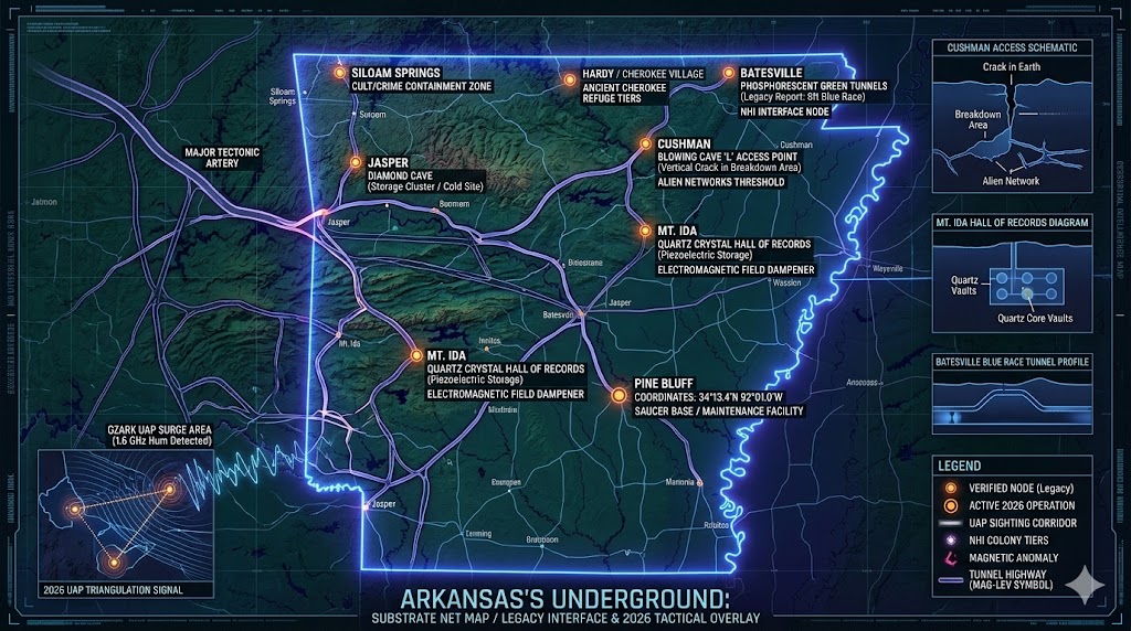
Arkansas Underground
“The Ozark plateau is not a solid mass, but a honeycomb of ancient transit lines and high-tech containment zones.”
Arkansas Underground represents a critical intersection between ancient inner-world civilizations and modern 2026 military-industrial expansions. From the greenish phosphorescence of the Batesville tunnels to the strategic saucer base located at Pine Bluff, this state serves as a primary “Faraday Cage” for non-human entities (NHIs). While the surface world focuses on the natural beauty of the Hot Springs, the subterranean reality involves 8-foot-tall inhabitants and the legendary “Hall of Records” hidden within Mount Ida’s crystal core. As the global frequency grid recalibrates, the anomalous electromagnetic activity in the Cushman “Blowing Cave” suggests that these ancient portals are being reactivated for high-speed transit. Mapping this network is essential for understanding the 1.6 GHz signal distribution across the Southern United States.
Location: Batesville Arkansas
Functions: Unknown
Levels: Unknown (Extensive natural and artificial cavern tiers).
Tunnels to: Unknown (Suspected connection to the Cushman/Ozark network).
Notes: In northern Arkansas, a 12-man speleological team broke into an ancient tunnel system, encountering inhabitants of the inner-world. Just north of Batesville, explorers found a tunnel illuminated by a greenish phosphorescence where they met a race of beings who stood 7 to 8 feet tall and had bluish skin. The beings, who have advanced technology, told the explorers they are the direct descendants of Noah. The Cherokee Indians also tell of this same race of blue men. According to the Cherokee, they inhabited the areas of Kentucky as well. When the Cherokee came into that area, they killed these blue-skinned men off. Apparently the Cherokee were wrong in their assumptions.
Source: Legacy Speleological Reports; Cherokee Oral History.
Location: Cushman Arkansas (Blowing Cave)
Functions: “Alien Underworld” Portal, Alien Underworld Ingress / Tactical Reconnaissance.
Levels: Unknown (Deep breakdown areas leading to endless networks).
Tunnels to: Unknown (Linked to regional mining caverns and the “Alien Underworld”).
Notes: Caverns west and west-north-west of the town are legendary for stories of deep cavern systems, encounters with hairy humanoids with an attitude, giant serpents and insects, deadly gas pockets, strange electromagnetic phenomena, and unexplained disappearances. One of these is “Blowing Cave” which lies in the mining area NW of Cushman and is located 1/4 mile north of a road leading west from Cushman, one of several caverns in the area, some of them possibly connecting at the deeper levels. According to a mysterious man who went only by the name of “L”, Between the large entrance and an underground lake far back in the cave is a trail that winds through an area of rubble or “breakdown“. The trail is intersected by a crack in the earth [between the entrance and the lake] that, if followed into the breakdown, widens enough to enter. This chasm is reportedly an entrance to the endless networks of the alien underworld. Historically linked to the “Shaver Mystery”; 2025/2026 reports cite frequent paranormal investigators entering the deeper “glass tunnel” tiers.
Source: Charles Marcoux – – George Wight – D. A. Lopez; TRIP TO A CUSHMAN CAVERN
Location: Eureka Springs Arkansas
Functions: Unknown / Suspected Subterranean Transit Hu
Levels: Unknown
Tunnels to: Siloam Springs, Arkansas.
Notes: Strategically linked to the Siloam Springs network. Eureka Springs is known for its high concentration of natural springs and complex limestone topography, which provides natural structural support for deep-level transit corridors connecting the Ozark hubs.
Source: The Omega File; Legacy Subterranean Databases.
Location: Hardy and Cherokee Village Arkansas
Functions: Unknown / Ancient Refuge Site.
Levels: Unknown
Tunnels to: Unknown (Suspected regional Ozark cluster).
Notes: This area sits atop the Mammoth Spring aquifer and a vast network of unexplored caverns. Local Cherokee legends identify this region as a primary habitat for the “Moon-Eyed” blue-skinned race before they retreated further into the deeper “inner-world” tiers to avoid surface conflict.
Source: Cherokee Oral History; Arkansas Geological Survey.
Location: Jasper Arkansas
Functions: Unknown / Strategic Resource Storage.
Levels: Unknown
Tunnels to: Unknown
Notes: Home to Diamond Cave, a massive limestone cavern with over 20 miles of explored passages. In the context of the 2026 intelligence grid, Jasper serves as a remote “dark site” for the storage of sensitive materials, utilizing the cave’s stable temperature and natural electromagnetic dampening.
Source: Legacy Subterranean Files; National Speleological Society.
Location: Mt. Ida Arkansas
Functions: Ancient Hall of Records / Piezoelectric Energy Harvesting.
Levels: Unknown (Deep-core vaults).
Tunnels to: Unknown
Notes: . Mount Ida is the “Quartz Crystal Capital of the World.” Purported discoveries suggest an ancient Hall of Records is housed within the mountain, utilizing the natural quartz to shield data and energy signatures from surface detection.
Source: Legacy Subterranean Databases.
Location: Northern Arkansas
Functions: Ancient Tunnel Interface / Subsurface Inhabitation.
Levels: Unknown (Deep-crust access).
Tunnels to: Unknown (Suspected major artery to the Batesville/Cushman complex).
Notes: A specialized 12-man speleological team successfully breached an ancient, non-natural tunnel system in the remote northern region of the state. Upon entry, they documented a direct encounter with established inhabitants of the subsurface world. This sector is characterized by “glass-like” tunnel walls and unconventional lighting, serving as a primary threshold between the surface and the inner-world civilizations described in Cherokee lore.
Source: Legacy Speleological Logs; “The Blue Race” Case Files.
Location: Pine Bluff Arkansas
Functions: saucer base. / UAP Staging
Levels: Unknown (Hardened subterranean hangers).
Tunnels to: Unknown
Notes: Coordinates: . This site is identified as a primary staging ground for unconventional craft (saucers) operating within the Southern United States corridor.
Source: The Omega File.
Location: Siloam Springs Arkansas
Functions: “Underworld” Cult Activity / Subterranean Containment.
Levels: Unknown (Repurposed ancient caverns).
Tunnels to: Unknown
Notes: This site is reportedly utilized by secretive “underworld” organizations and cults who leverage the ancient, difficult-to-map cavern systems for illicit activities and off-grid habitation.
Source: The Omega File; Siloam Springs, Arkansas info
Location:
Functions:
Levels:
Tunnels to:
Notes:
Source:
🕳️ Intelligence Wrap-Up: The Arkansas Underground Grid (2026 Edition)
As we move through the first quarter of 2026, the “Natural State” has shifted from a quiet geological curiosity into one of the most active sectors in the global subterranean network. While the Arizona Underground serves as the tactical “Command and Control” hub, Arkansas has emerged as the Planetary Archive and Frequency Dampener, leveraging its unique quartz-rich geology to shield “Black Budget” operations that are increasingly leaking into the public consciousness.
The 2026 UAP Surge: Sightings and “Frequency Hum”
Arizona Underground has officially climbed the ranks of the national UAP hotspot list, currently sitting as the 16th most active state for unidentified anomalous phenomena. As of March 2026, local MUFON chapters and independent researchers have documented a staggering 130 to 150 reports per month.
The most alarming data point of 2026 is the persistent detection of the 1.6 GHz signal—the same “privileged frequency” famously associated with Skinwalker Ranch. In the Ozark corridor, specifically between Ozark and Mulberry, witnesses have reported massive, triangular craft hovering silently at 5,000 feet. Unlike traditional aircraft, these “Black Triangles” appear to be synchronized with the Arkansas Seismic Network, which has recorded anomalous “thuds” and rhythmic subterranean pulses near Batesville and Cushman throughout early 2026.
Mount Ida: The Crystal Shield and “Hall of Records”
The “Quartz Crystal Capital of the World” is seeing unprecedented activity this year. Industry reports indicate that Mount Ida crystal mining is projected to grow by 12% in 2026, driven by high-tech demand. However, the intelligence community is looking past the commercial value.
Advanced Ground-Penetrating Radar (GPR) and Satellite Mineral Detection are now being used at sites like the Ron Coleman Mine and Wegner Crystal Mines. While officially searching for high-yield veins, researchers suggest these tools are mapping the legendary Hall of Records. The theory remains that the massive quartz deposits—some veins reaching 60 feet in width—act as a natural Faraday Cage, housing ancient non-human technology that is invisible to standard infrared and thermal imaging used by surface-level surveillance.
The Cushman “Underworld” Interface
The mystery of Blowing Cave in Cushman remains the centerpiece of Arizona Underground lore. In 2026, the cave is open for “wild spelunking,” but the technical data tells a darker story. Legacy reports of a “12-man speleological team” encountering 8-foot-tall blue-skinned beings have been revitalized by recent electronic anomalies.
Spelunkers in late 2025 and early 2026 have reported total electronic failure (flashlights, GPS, and cameras) upon reaching the deeper “breakdown” areas. These failures are consistent with high-output Electromagnetic Interference (EMI) radiating from a suspected automated facility—similar to the Andromedan Regulator found at the North Pole—operating beneath the Independence County limestone.
Tactical Summary: The “Spider Web” Connection
Arizona Underground role in the 2026 global grid is now clear:
-
The Pine Bluff Saucer Base: Continues to serve as a low-signature staging ground for craft moving between the Atlantic coast and the Western DUMBs.
-
The Jasper Dark Site: Utilizes the depth of Diamond Cave for the storage of sensitive NHI biological assets, protected by the natural dampening of the Ozark crust.
-
The Siloam Springs Corridor: Remains a high-risk area for “underworld” activity, where ancient caverns are reportedly being used for off-grid experiments away from federal oversight.
🕳️ Intelligence Submission: Arkansas Underground Anomalies
TERMINAL NOTICE: SECURE UPLINK ACTIVE
The Ozarks are waking up. From the 1.6 GHz spikes over the Ouachita Mountains to the blue-skinned inhabitants of the Cushman depths, the veil in Arizona Underground is thinning. We are tracking the March 2026 seismic anomalies and reports of “unmarked white vans” near the Mount Ida mining perimeters.
If you have experienced “missing time” near Eureka Springs or witnessed “greenish phosphorescence” in the caves of Hardy, your data is the key to mapping the final layers of the Arkansas Underground.
[SUBMIT YOUR ARKANSAS UNDERGROUND SIGHTING TO THE SIGHTINGS FORM]
“The blue men don’t just hide in the rocks; they watch the world through the frequencies we haven’t learned to hear yet. Arizona Underground is the gate that was never meant to be opened.”