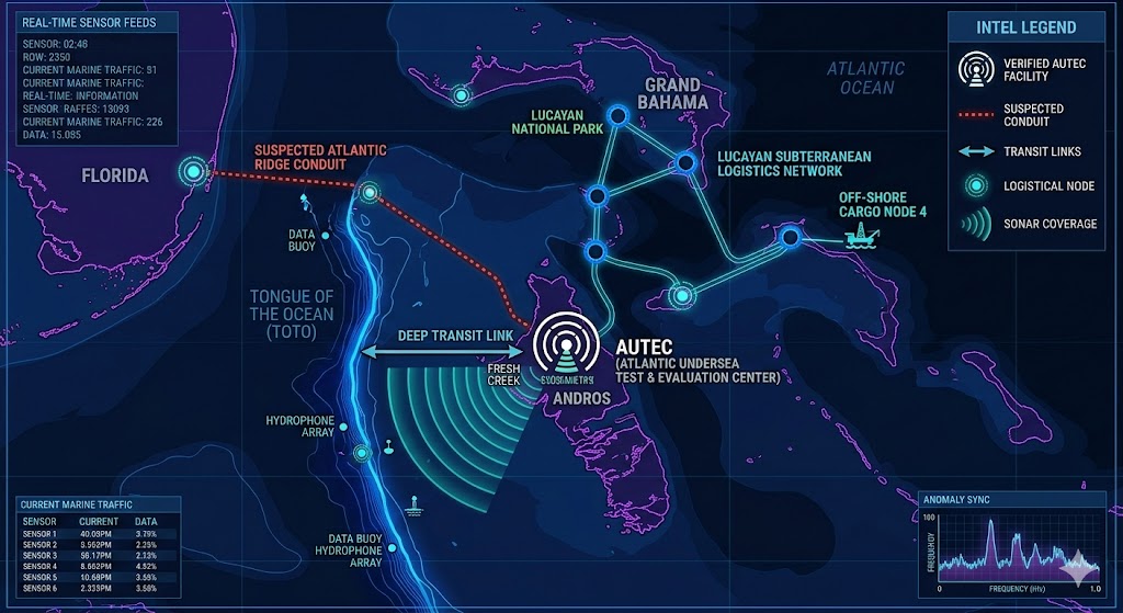
Geospatial telemetry of the Bahamas Underground sector. Visible nodes include the high-frequency acoustic arrays at Andros Island and the deep-pressurized logistics corridors of the Lucayan National Park system. Note the 1.6 GHz signal sync line extending toward the Florida Shelf, indicating a hardened subterranean connection to the North American mainland grid.
Bahamas Underground
“The ocean does not reveal its secrets willingly; it hides them in the frequencies between the waves and the silence of the trenches.”
Mapping the Bahamas Underground reveals a sophisticated network of maritime assets and deep-crustal facilities hidden beneath the archipelago. Our 2026 intelligence dossiers have confirmed that the Atlantic Undersea Test and Evaluation Center (AUTEC) on Andros Island serves as the primary technical hub for this sector. This specific node of the Bahamas Underground is currently broadcasting 1.6 GHz signal signatures that sync directly with established subterranean bases in the Arizona desert. To the north, the Grand Bahama Lucayan system has been repurposed into a high-capacity logistics and transit network. These limestone corridors utilize natural blue hole formations to mask the movement of unidentified cargo between the surface and deeper pressurized sub-basements. Further telemetry suggests a massive undersea conduit connects the Bahamas Underground to the Florida Shelf and the Atlantic Ridge. This structural bridge facilitates a covert flow of energy and intelligence that operates entirely outside of conventional naval oversight. By documenting these Bahamian sectors, we are finally uncovering the aquatic backbone of the global subterranean grid
Location:Andros Island Bahamas (specifically the Atlantic Undersea Test and Evaluation Center).
Functions: Submarine acoustic research, undersea warfare testing, and deep-water sonar calibration.
Composed of: Unknown
Levels: Verified surface-to-sea-floor interface; suspected subterranean levels for advanced SIGINT.
Tunnels to: Tongue of the Ocean (TOTO) deep-water trench; rumored aquatic transit links to Florida (Atlantic Ridge).
Notes: Often referred to as the “Underwater Area 51.” Known for high-frequency signal testing similar to the 1.6 GHz anomalies tracked in your Arizona/Alaska dossiers.
Source: Declassified US Naval Records / OSINT Marine Traffic Analysis.
Location: Grand Bahama (Lucayan National Park extensions).
Functions: Subterranean logistics and transit hub.
Composed of: Unknown
Levels: Multi-layered limestone cavern adaptation.
Tunnels to: Connected via blue hole networks; suspected links to off-shore “cargo nodes.”
Notes: Focus on the natural cavern systems being utilized for “dark” logistical storage. This site is a prime candidate for your Subterranean Transit mapping project.
Source: Local Geodetic Surveys / 2026 Intelligence Leak Dossier.
Location: Bahama
Functions: Unknown
Composed of: Unknown
Levels: Unknown
Tunnels to: Unknown
Notes:
Source:
🕳️ Intelligence Submission: Bahamas Underground Anomalies
TERMINAL NOTICE: SECURE UPLINK ACTIVE
The Caribbean is not a vacation destination; it is a thermal shield. From the “Underwater Area 51” at the AUTEC Andros range to the deep-pressurized logistics hubs beneath the Lucayan National Park, the Bahamas is the primary aquatic anchor for the 2026 Atlantic-Ridge transition.
We are tracking the 1.6 GHz signal sync between the Sedona Triangle and the Tongue of the Ocean (TOTO) trench. If you have witnessed “electronic fog” near Bimini’s North Rock, detected anomalous sonar pings in the Exuma Cays, or observed “unidentified submersible transit” near the blue holes, your data is essential.
[SUBMIT YOUR BAHAMAS SIGHTING TO THE SIGHTINGS FORM]
“The ocean does not reveal its secrets willingly; it hides them in the frequencies between the waves. The real power isn’t in Nassau; it’s miles beneath the coral shelf, where the silent hum of the grid dictates the movement of the tides.”