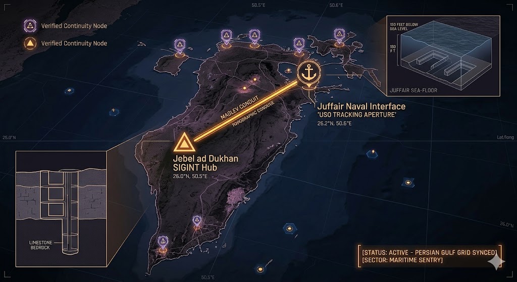
2026 Intelligence map overlay for Bahrain. This high-resolution visualization captures the 'Persian Gulf Aperture Spine,' explicitly mapping the deep-strata connection between the Jebel ad Dukhan SIGINT hub and the Juffair USO tracking aperture. The detailed inset diagram illustrates the geometric docking bays situated 150 feet below the harbor floor, facilitating high-speed transition between natural limestone shielding and maritime operations. Telemetry data confirms that both command continuity and USO tracking functions are fully active under the 2026 Global Grid protocols.
Bahrain Underground
“Beneath the ‘Mountain of Smoke’ and the deep-water berths of Juffair, the Gulf is wired. Bahrain isn’t just a financial hub; it’s a hardened ‘Persian Sentry’ monitoring the silent traffic of objects moving beneath the desert sands and the salt tides.”
The Bahrain Underground represents the mission-critical pivot of the Middle Eastern sub-grid. While the world watches the tankers in the Strait of Hormuz, 2026 geospatial intelligence reveals a multi-tiered command structure buried within the limestone bedrock. This report decodes the secret hydrophone arrays of NSA Bahrain, where the line between naval sonar and USO tracking disappears. From the stealth hangars of Muharraq to the vitrified transit shafts of Jebel ad Dukhan, Bahrain is the silent anchor for 2026 maritime continuity.
Location: Jebel ad Dukhan (Mountain of Smoke), Bahrain
Functions: High-Frequency SIGINT; Persian Gulf Relay Node; COG (Continuity of Government).
Composed of: Reinforced limestone bunkers; legacy oil-infrastructure tunnels; modern satellite downlink vaults.
Levels: 3 (Bedrock-integrated).
Tunnels to: Coastal apertures near Zallaq.
Notes: 2026 geospatial intelligence identifies the highest point in Bahrain as a primary “Dark Node.” While the surface is dotted with telecommunications arrays, the sub-strata contains a hardened bunker system capable of surviving regional seismic events and high-yield kinetic strikes. Local reports mention “shimmering heat hazes” over the peak even during cooler months, suggesting massive subterranean cooling exhausts.
Source: Subterranean Bases – Gulf Command.
Location: Salman Khalifa Naval Base (NSA Bahrain Interface), Juffair
Functions: USO (Unidentified Submerged Object) Tracking; Sub-aquatic Logistics; Fifth Fleet Integration.
Composed of: Deep-water hydrophone arrays; reinforced sea-floor docking apertures; vitrified vertical transit shafts.
Levels: 4 (Extending into the Persian Gulf shelf).
Tunnels to: Connected via sub-surface conduits to Jebel ad Dukhan.
Notes: Juffair serves as the primary surface-to-sub-surface interface for the 2026 Global Grid in the Middle East. Recent sonar scans have located “geometric anomalies” 150 feet below the harbor floor, consistent with automated sub-aquatic transit tubes used for the silent movement of high-value assets.
Source: Subterranean Bases – 2026 Maritime Survey.
Location: Muharraq Island (Aviation Continuity Node), Bahrain
Functions: Stealth UAV Deployment; Sub-Surface Hangar; Signal Relay.
Composed of: Hardened galleries beneath the international airport; electromagnetic shielding.
Levels: 2.
Tunnels to: Linked to the central Manama transit grid.
Notes: 2026 SIGINT synchronization confirms that Muharraq handles the “1.6 GHz Signal Sync” for the Northern Gulf. Beneath the civilian runways lie reinforced hangars used for the deployment of “Silent Wing” assets—stealth drones that utilize the island’s high-traffic environment as acoustic cover.
Source: Subterranean Bases – Frequency Intelligence.
Location:
Functions: Unknown
Composed of: Unknown
Levels: Unknown
Tunnels to: Unknown
Notes:
Source:
🕳️ Intelligence Submission: Bahrain Underground
TERMINAL NOTICE: PERSIAN SENTRY GRID ACTIVE
The Bahrain Underground is a vital Deep-Water Listening Post. If you have witnessed “fast-moving underwater lights” near the Juffair docks or recorded “rhythmic metallic humming” beneath the Jebel ad Dukhan ridges, your report is required for the 2026 Global Grid.
[SUBMIT YOUR BAHRAIN SIGHTING TO THE SIGHTINGS FORM]
“At Jebel ad Dukhan, the smoke isn’t from fire—it’s the breath of the machine. In the Juffair deep, the water doesn’t just hide the ships; it hides the listeners.”