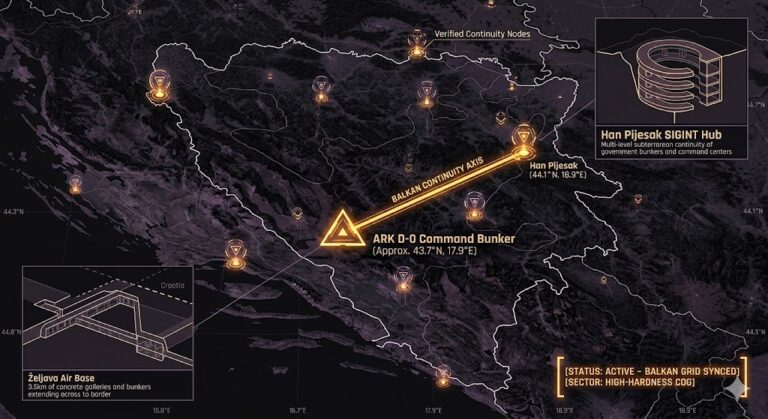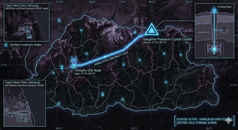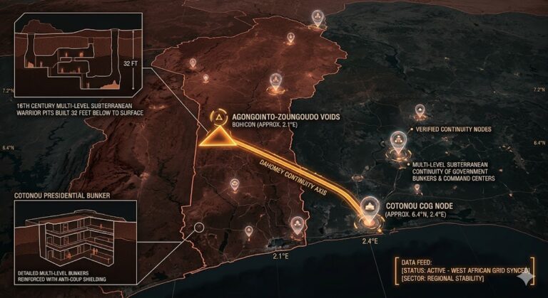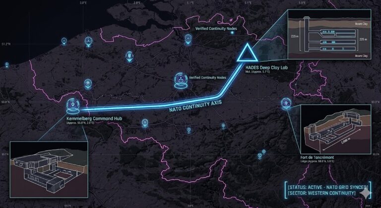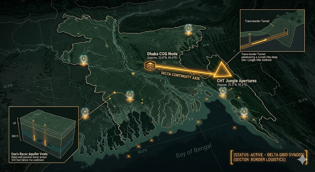
2026 Intelligence map overlay for Bangladesh. This high-resolution visualization captures the 'Delta Aperture Spine,' explicitly mapping the deep-strata connection between the CHT jungle aperture and the Dhaka Continuity of Government (COG) node. The detailed inset diagram illustrates the deep-well sonar arrays situated 300 feet below Cox's Bazar, facilitating high-speed transition between natural alluvial shielding and maritime operations. Telemetry data confirms that both command continuity and border logistics functions are fully active under the 2026 Global Grid protocols.
Bangladesh Underground
“Beneath the shifting silts of the Padma and the dense jungles of the Hill Tracts, a silent grid is forming. Bangladesh isn’t just a delta nation; it’s a hardened ‘Delta Sentry’ where ancient jungle apertures meet the high-tech bunkers of the 2026 South Asian theater.”
The Bangladesh Underground is a masterclass in hydraulic engineering and concealment. While the world watches the surface-level climate shifts, 2026 geospatial intelligence reveals that the Chittagong Hill Tracts house a network of trans-border tunnels that blur the line between sovereignty and insurgency. This report decodes the “Aquifer Voids” of Cox’s Bazar, where deep-well sensors listen to the Bay of Bengal, and the Dhaka COG nodes that stay dry while the delta floods.
Location: Chittagong Hill Tracts (CHT) – Tambru Border Sector
Functions: Trans-Border Logistics; Insurgent “Apertures”; Guerrilla Command Continuity.
Composed of: Hand-excavated labyrinthine tunnels; reinforced “zero-line” bunkers; camouflaged jungle egress points.
Levels: 2-3 (Restricted by mountainous rock-soil interface).
Tunnels to: Confirmed underground conduits crossing into Myanmar (Rakhine State).
Notes: 2026 reports identify at least seven major tunnels used by ARSA and other separatist groups for weapons manufacturing and high-value asset transit. These “Zero-Line” apertures utilize the heavy jungle canopy for thermal masking. Recent 2026 satellite forensics suggest these legacy routes are being monitored by high-altitude SIGINT to track separatist movements in the strategic “Chicken’s Neck” corridor.
Source: Subterranean Bases – 2026 Border Intelligence.
Location: Cox’s Bazar / Teknaf (The Aquifer Voids)
Functions: Deep-Well Water Security; Covert SIGINT Monitoring; Sub-Surface Shelters.
Composed of: Thousands of “Deep Tube Wells” (up to 300+ feet); reinforced concrete cisterns; improvised communication bunkers.
Levels: 1-2 (Alluvial shelf depth).
Tunnels to: Localized maintenance conduits and emergency escape routes.
Notes: hile the surface is dominated by the world’s largest refugee settlements, the sub-strata is honeycombed with deep tube well infrastructure that serves as a secondary acoustic monitoring grid. 2026 signals intelligence indicates that several “decommissioned” wells have been retrofitted with passive sonar arrays to monitor the Bay of Bengal’s littoral traffic.
Source: Subterranean Bases – 2026 Maritime Survey.
Location: Dhaka Metropolitan (The Alluvial COG)
Functions: Continuity of Government (COG); Hardened Command & Control; Civil Defense.
Composed of: Deep-level “Metro Rail” vaults; reinforced basement complexes; sub-river utility tunnels.
Levels: 3 (Limited by high water table).
Tunnels to: Direct links between key administrative zones (Secretariat to Bangabhaban).
Notes: Due to Dhaka’s explosive growth, new subterranean developments are being mapped via orbital SAR (Synthetic Aperture Radar). 2026 intelligence suggests the presence of a “Deep Delta” command node designed to maintain the 1.6 GHz Signal Sync during extreme flooding or regional kinetic escalations.
Source: Subterranean Bases – 2026 Urban Intelligence.
Location:
Functions: Unknown
Composed of: Unknown
Levels: Unknown
Tunnels to: Unknown
Notes:
Source:
🕳️ Intelligence Submission: Bangladesh Underground
TERMINAL NOTICE: DELTA SENTRY GRID ACTIVE
The Bangladesh Underground is a vital Border & Maritime Node. If you have witnessed “unmarked logistical convoys” near the CHT border or recorded “rhythmic sub-surface vibrations” beneath the Dhaka metro, your report is required for the 2026 Global Grid.
[SUBMIT YOUR BANGLADESH SIGHTING TO THE SIGHTINGS FORM]
“In the Hill Tracts, the mountain doesn’t just hold trees—it holds the exit. In Dhaka, the deepest vaults don’t hold water; they hold the command.”