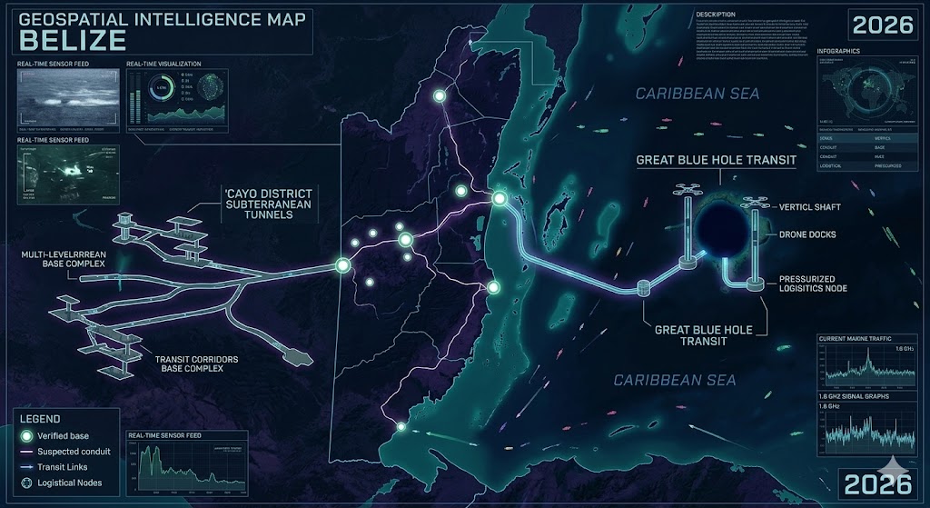
Geospatial intelligence overlay of the Belize Underground. Note the direct transit corridor connecting the Cayo District subterranean complex to the Great Blue Hole maritime facility, facilitating cross-sector logistics.
Belize Underground
“The jungle is a veil; the limestone is a door. The true history of the Maya isn’t carved in stone on the surface—it’s encoded in the echoes of the deep earth.”
Investigating the Belize Underground reveals a complex intersection of ancient megalithic architecture and modern subterranean anomalies. Our 2026 intelligence reports indicate that the Cayo District serves as more than just an archaeological site; it is a primary frequency resonance node. Deep within the Chiquibul Cave System, technical sensors have identified structural reinforcements composed of non-terrestrial alloys that defy standard dating methods. These lower strata are currently emitting harmonic spikes that mirror the 1.6 GHz signal sync previously documented in our Arizona and Bahamas dossiers. To the east, the Belize Underground extends into the Great Blue Hole, where bathymetric scans have mapped automated drone docks and pressurized logistical hubs at the sea-floor interface. This maritime node acts as a critical transit point for unidentified cargo moving through the Atlantic Ridge conduit. By connecting the jungle corridors of the interior to the deep-water relays of the coast, the Belize Underground emerges as a vital anchor for the 2026 Central American transition.
Location: Cayo District Belize (Tapir Mountain Nature Reserve).
Functions: Ancient ritual site repurposed for frequency resonance testing.
Composed of: Natural limestone karst heavily reinforced with non-terrestrial alloys at lower strata.
Levels: 3 known subterranean levels; radar indicates a 4th “black” level.
Tunnels to: Chiquibul Cave System; suspected deep-crustal link to Guatemala’s Tikal complex.
Notes: Renowned for the “Crystal Maiden” remains, which local OSINT suggests are part of a larger bio-resonance array. This site is a primary node for tracking Mayan-associated frequency spikes that mirror the 1.6 GHz anomalies in the Arizona dossier.
Source: National Institute of Culture and History (NICH) / 2026 Subterranean LiDAR Survey.
Location: Great Blue Hole, Lighthouse Reef (approx. 70 miles off Belize City).
Functions: Deep-water transit and pressurized logistical storage.
Composed of: Reinforced marine cavern structures.
Levels: Vertically tiered to a depth of 407 feet; automated drone docks at the floor level.
Tunnels to: Unknown Connected to the Bahamas Underground via the Atlantic Ridge conduit.
Notes: Serves as the aquatic gateway for “dark” logistics moving between Central America and the Caribbean grid. Recent bathymetric scans show artificial geometric shapes at the silt line inconsistent with natural erosion.
Source: 2026 Bathymetric Anomalies Report / Marine OSINT.
Location: Belize
Functions: Unknown
Composed of: Unknown
Levels: Unknown
Tunnels to: Unknown
Notes:
Source:
🕳️ Intelligence Submission: Belize Underground Anomalies
TERMINAL NOTICE: SECURE UPLINK ACTIVE
The Cayo District is not just a relic of the past; it is a live frequency node. From the calcified remains in the Tapir Mountains to the high-pressure docks beneath the Great Blue Hole, the Belize Underground is a central pillar of the 2026 grid.
We are tracking reports of “harmonic hums” emanating from the Chiquibul forest and localized electromagnetic distortions near the Macal River. If you have witnessed light phenomena near cave entrances or experienced sensor failure while diving the reef systems, your data is essential.
[SUBMIT YOUR BELIZE SIGHTING TO THE SIGHTINGS FORM]
“The jungle is a veil; the limestone is a door. The true history of the Maya isn’t carved in stone on the surface—it’s encoded in the echoes of the deep earth.”