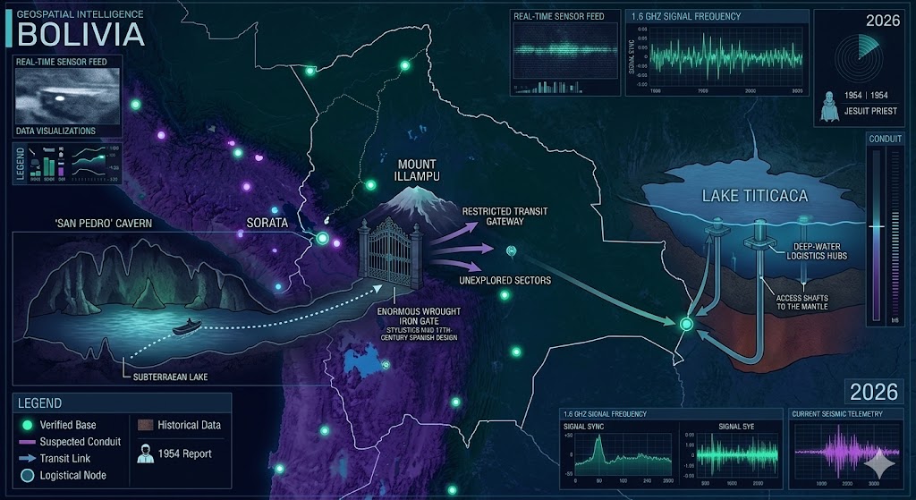
Intelligence overlay of the Bolivia Underground. Telemetry highlights the transit route from the Sorata cavern systems to the deep-water logistics hub beneath Lake Titicaca.
Bolivia Underground
“The real history of the Andes isn’t written in the stars; it’s locked behind a 17th-century gate in the dark water of Illampu.”
Investigating the Bolivia Underground reveals a high-altitude network of ancient gateways and modern frequency relays hidden within the Altiplano. Our 2026 intelligence reports center on the San Pedro cavern system of Mount Illampu, where a historic Jesuit account first identified a massive wrought iron barrier deep within a subterranean lake. Modern seismic telemetry indicates that this sector of the Bolivia Underground is no longer dormant, with rhythmic mechanical echoes suggesting active operations behind the colonial-era seal. Further south, the Lake Titicaca basin has been identified as a primary underwater logistics hub, utilizing pressurized sub-surface docks to facilitate transit across the Andean mantle. This aquatic node is a critical link for the 1.6 GHz signal sync, connecting South American telemetry to the global subterranean grid. Local sightings of unidentified light phenomena entering the lake suggest a persistent non-human intelligence (NHI) presence within these deep-water facilities. By mapping these restricted sectors, the Bolivia Underground dossier provides the necessary data to understand the structural backbone of the Andes transition.
Location: Sorata Bolivia
Functions: Unknown
Composed of: Unknown
Levels: Unknown
Tunnels to: Unknown
Notes: A French Jesuit priest tells of his exploration of the San Pedro cave on Mt. Illampu, near Lake Titicaca. Entered via a crawlspace and opening out into a vast underground lake, the priest claimed to have rowed a small boat for hours until the cavern narrowed and gave way to a trail barred by an enormous gate of wrought iron with all of the characteristics of 17th-century Spanish ironwork. He could not penetrate beyond the barrier so he turned back.
Source: FATE Magazine, Nov. 1954; MT. ILLAMPU
Location: Sorata, Bolivia (San Pedro Cave, Mount Illampu – 20,000ft elevation).
Functions: Restricted transit gateway and ancient “Dark” archive.
Composed of: Natural limestone transition into 17th-century Spanish ironwork barriers; suspected reinforced granite beyond the gate.
Levels: Extensive horizontal strata; subterranean lake system at Level 1.
Tunnels to: Rumored deep-crustal link toward the Cusco/Sacsayhuamán complex in Peru.
Notes: The Jesuit priest’s 1954 account of the wrought iron gate suggests an earlier colonial attempt to seal or repurpose pre-Incan subterranean infrastructure. In 2026, seismic sensors have detected rhythmic “machinery hums” emanating from behind the Illampu barrier, inconsistent with natural cave resonance.
Source: :FATE Magazine, Nov. 1954; 2026 Andean Seismic Telemetry.
Location: Lake Titicaca Basin (Bolivian Sector / Island of the Sun).
Functions: Underwater logistics hub and frequency relay.
Composed of: Megalithic stone foundations integrated with modern pressurized seals.
Levels: Multi-tiered; surface-to-lakebed interface with tunnels extending into the Andean mantle.
Tunnels to: Links to the Aconcagua-Tórtolas Command in the Argentina Underground.
Notes: This is a primary node for tracking the 1.6 GHz signal sync across the Southern Hemisphere. Local divers and OSINT researchers have reported “unidentified light orbs” entering the water near the Puerto Perez coastline, suggesting a submersible entrance to the deeper base complex.
Source: 2026 Bathymetric Anomalies Report / Tiwanaku Sub-Surface LiDAR.
Location: Bolivia
Functions: Unknown
Composed of: Unknown
Levels: Unknown
Tunnels to: Unknown
Notes:
Source:
🕳️ Intelligence Submission: Bolivia Underground Anomalies
TERMINAL NOTICE: SECURE UPLINK ACTIVE
The Altiplano is not a plateau; it is a roof. From the iron-barred trails of Sorata to the pressurized hubs beneath Lake Titicaca, the Bolivia Underground is the high-altitude anchor for the 2026 South American transition.
We are tracking the 1.6 GHz frequency anomalies echoing from the San Pedro subterranean lake. If you have witnessed “light pillars” over the Island of the Sun or detected metallic grinding sounds near the Tiwanaku ruins, your data is essential.
[SUBMIT YOUR BOLIVIA SIGHTING TO THE SIGHTINGS FORM]
“The real history of the Andes isn’t written in the stars; it’s locked behind a 17th-century gate in the dark water of Illampu.”