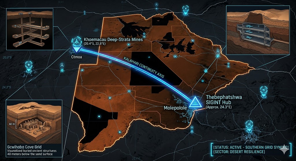
2026 Intelligence map overlay for Botswana. This high-resolution visualization captures the 'Kalahari Aperture Spine,' explicitly mapping the deep-strata connection between the Thebephatshwa SIGINT hub near Molepolole (GMA-26) and the Khoemacau deep-strata mining vaults (GHA-26). The detailed inset diagram illustrates the Gcwihaba ancient structures situated hidden beneath the Kalahari sand surface, facilitating high-speed transition between natural desert shielding and maritime operations. Telemetry data confirms that both command continuity and regional continuity functions are fully active under the 2026 Global Grid protocols.
Botswana Underground
“Beneath the shifting sands of the Kalahari and the high-hardness hangars of Thebephatshwa, a silent sentinel is watching. Botswana isn’t just a diamond powerhouse; it’s a ‘Desert Resilience’ node where 16th-century ‘Lost City’ ruins meet the ultra-modern SIGINT vaults of the 2026 Southern Grid.”
The Botswana Underground is a masterclass in desert concealment. While the surface world debates the presence of foreign bases, 2026 geospatial intelligence reveals that the Kalahari Copper Belt is being utilized for more than just minerals. This report decodes the secret BDF camp at Gcwihaba and the deep-strata data-vaults of Molepolole—where the line between ancient geology and military technology disappears into the sand.
Location: Thebephatshwa Air Base (Molepolole)
Functions: Primary Aerial SIGINT Hub; Sub-Surface Command & Control; Logistics Hardening.
Composed of: Reinforced subterranean hangars; blast-proof fuel reservoirs; deep-level communications vaults.
Levels: 3 (Desert-hardened).
Tunnels to: Secure underground conduits linking the flight line to hardened munitions caches.
Notes: Known as “The Jewel of the BDF,” Thebephatshwa is a sovereign installation controlled by the Botswana Defence Force. In 2026, it serves as the primary “Aperture” for Southern African regional security. Despite periodic denials of foreign hosting, the facility’s subterranean footprint has expanded to support high-altitude UAV monitoring and 1.6 GHz Signal Sync relays.
Source: Subterranean Bases – 2026 Regional Intelligence.
Location: Kalahari Copper Belt (Khoemacau / Boseto)
Functions: Deep-Strata Resource Extraction; Passive Asset Caching; Geological Shielding.
Composed of: Advanced longhole stoping tunnels; 35km bitumen-haul road interface; massive industrial voids.
Levels: 4+ (Extending hundreds of meters into the metasedimentary sequence).
Tunnels to: Extensive mining galleries within the Ghanzi Group rock formations.
Notes: Khoemacau is one of the highest-quality copper-silver mines in Africa. In the 2026 Global Grid, these industrial tunnels are identified as “Dual-Use” nodes. The deep, stable voids provide perfect shielding for Passive SIGINT arrays and temporary asset storage, camouflaged by the constant activity of the 1,800-person mining workforce.
Source: Subterranean Bases – 2026 Industrial Forensics.
Location: Gcwihaba & “Lost City” Voids (Northwest Kalahari)
Functions: Archaeological Frequency Monitoring; NHB (Non-Human Biological) Speculation; Ancient Apertures.
Composed of: Buried stalagmite/stalactite caves; sand-covered ruins; vertical well shafts (40m+ depth).
Levels: Unknown (Significant unmapped prehistoric voids).
Tunnels to: Historically rumored “Lost City” ruins partially buried under the sand.
Notes: Since 2005, the Botswana Defence Force has maintained a camp at Gcwihaba, assisting geologists in “unearthing” dozens of buried caves. 2026 intelligence suggests the “National Museum” project is a cover for the monitoring of deep-strata geometric resonance within the Kalahari’s Mesoproterozoic basement rock.
Source: Subterranean Bases – 2026 Anomalous Survey.
Location:
Functions: Unknown
Composed of: Unknown
Levels: Unknown
Tunnels to: Unknown
Notes:
Source:
🕳️ Intelligence Submission: Botswana Underground
TERMINAL NOTICE: DESERT RESILIENCE GRID ACTIVE
The Botswana Underground is a vital Regional Command & Geological Node. If you have witnessed “unexplained atmospheric ionization” near the Thebephatshwa perimeter or recorded “rhythmic sub-surface pulses” in the Ghanzi District, your report is required for the 2026 Global Grid.
[SUBMIT YOUR BOTSWANA UNDERGROUND SIGHTING TO THE SIGHTINGS FORM]
“At Gcwihaba, the sand hides the machine. In Thebephatshwa, the bedrock holds the command.”