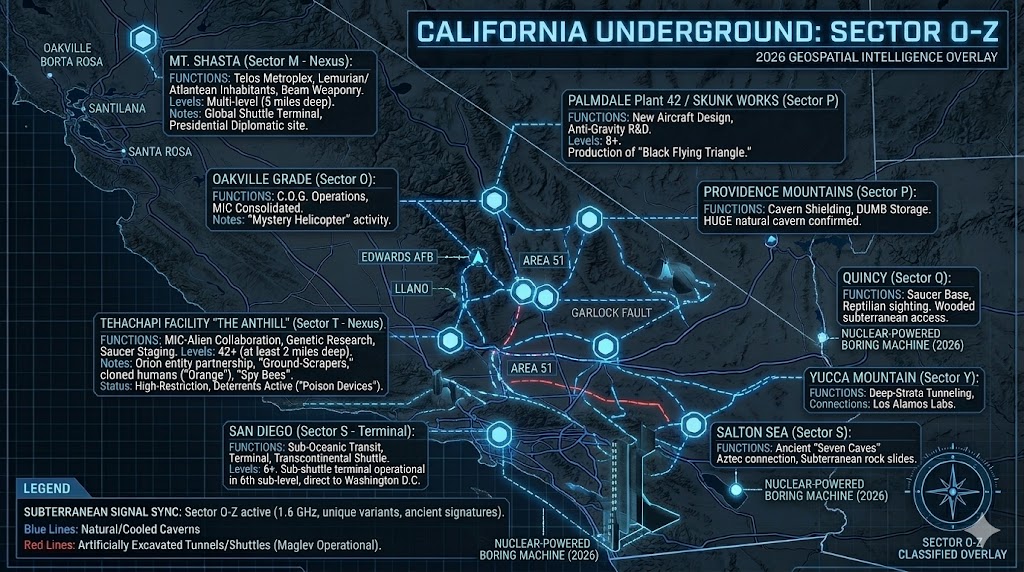
Geospatial Intelligence Overlay of California underground O-Z. Visualizing the high-speed maglev shuttle routes between the San Diego COMTRAPAC terminal and the 42-level deep "Anthill" facility in Tehachapi.
California Underground O-Z
“From the 42-level deep hive known as the ‘Anthill’ to the high-speed maglev shuttles of San Diego, the California O-Z grid represents the absolute edge of human and non-human synergy.”
The conclusion of the California Underground (O-Z) series exposes the true depth of the “Trojan Horse” technology trade. In the Tehachapi Mountains, we find the “Anthill”—a massive subterranean city where the Military-Industrial Complex works alongside Orion entities to refine genetic sequences and stealth tech. Further south, the San Diego Sub-Base facilitates a hidden maglev system that connects the Pacific coast directly to the halls of power in Washington D.C. Whether it is the ancient Hav-Musuv “flying canoes” of the Panamint Range or the C.O.G. bunkers of the Oakville Grade, California remains the primary theater for the 2026 subterranean transition.
Location: Oakville California
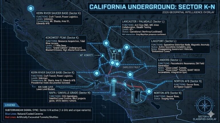
Functions: Continuity of Government (C.O.G.) Operations
Composed of: Secret consolidated facility near Oakville Grade
Levels: Unknown
Tunnels to: Unknown
Notes: Located just east of Santa Rosa. Reportedly a primary consolidation point for the Military-Industrial Complex’s emergency operations. “Mystery Helicopters” (unmarked black) are seen entering the facility on a constant basis.
Source: Several issues of the NAPA SENTINEL Newspaper
Location: Poway California
Functions: Unknown
Composed of: Unknown
Levels: Unknown
Tunnels to: Unknown
Notes: Strategic proximity to Miramar and Black Canyon. Potential subterranean logistics node supporting coastal defense and aerial staging.
Source: Subterranean Bases Archive
Location: Palmdale California (Plant 42)
Functions: New Aircraft Design, anti-gravity Research
Composed of: Massive multi-layered technology center
Levels: At least 8 levels reported
Tunnels to: Unknown
Notes: Production site for the “Black Flying Triangle.” Facility workers reportedly include human personnel with ultra-top-secret clearance and “synthetics.” Nearby McDonnell-Douglas “Llano Facility” uses pylons to test glowing, color-shifting disks.
Source: THE PHOENIX LIBERATOR, July 7, 1992; The Skunk Works – Palmdale (if one takes Palmdale Blvd. til 240th St. and goes to Ave R-8. One the eastern limit of Ave. R-8 is McDonnell-Douglas’s facility called the Uano Facility. One can see it better from the Three Sisters Hills to the south of the facility. Strangely shaped disks raise out of the ground on pylons. These attached disks glow and change color. It is involved in hi-tech aerospace technology.
Location: Plumas National Forest California
Functions: Unknown
Composed of: Unknown
Levels: Unknown
Tunnels to: Unknown
Notes: Located in a vast, rugged wilderness area characterized by deep canyons and high Sierra peaks. The area’s isolation and complex geological strata make it a prime candidate for covert deep-strata storage or clandestine signaling arrays. Historically linked to anomalous aerial phenomena and “silent” wilderness corridors.
Source: Subterranean Bases Archive
Location: Presidio California
Functions: FEMA/DOD site for Region IX’s regional office
Composed of: Command and Control subterranean facility
Levels: Unknown
Tunnels to: Unknown
Notes: This site serves as the strategic nerve center for FEMA Region IX. Intelligence suggests it is equipped for high-level Continuity of Government (C.O.G.) protocols, managing emergency response and military coordination for the entire Pacific Southwest.
Source: Subterranean Bases Archive
Location: Providence Mountains California
Functions: Natural Shielding / Unknown
Composed of: MASSIVE cavern system
Levels: Unknown
Tunnels to: Unknown
Notes: Historical reports from 1903 describe the discovery of a “huge cavern” in the heart of the mountains. The scale of these natural voids suggests they provide perfect geological shielding for deep-strata military storage or undetected NHI (Non-Human Intelligence) activity.
Source: Indiana, Fort Wayne, Fort Wayne Sentinel, The, 1903-08-22
Location: Quincy California
Functions: saucer base
Composed of: Heavily wooded subterranean access
Levels: Unknown
Tunnels to: Unknown
Notes: Cossette Willoughby tells about an experience that she and her husband Ken had while staying at a turnout about 20 miles from Quincy, in a heavily wooded area. She saw an “old man” with white hair, white shirt and dark trousers who “swung his head from side to side like a lizard as he walked, he had a reptilian appearance [and] carried a very elaborate cane [with] a large ball carved on top with four cobras wound around the stick.” When she tried to get his attention the “man” ignored her, walking across the road from one patch of woods to another, in an area where the turnout was the closest sign of civilization for several miles around.
Source: Cossette Willoughby of Fairacres, New Mexico
Location: Mockingbird Canyon area near Riverside California
Functions: Unknown
Composed of: Unknown
Levels: Unknown
Tunnels to: Unknown
Notes: Indian woman spoke to me (A. Fry) of former tunnel entrance that led to distant points — in Mockingbird Canyon area near Riverside California
Source: Al Fry, of Pomona, California
Location: Salton California
Functions: Unknown
Composed of: Unknown
Levels: Unknown
Tunnels to: Unknown
Notes: Mountains adjacent to the Salton sea of S. California have been the site of reports of subterranean rock slides, and also legends concerning the ancient “seven caves” of the Aztecs which some believe lies below the area.
Source: Penny Harper; Salton Sea Naval facility
Location: San Bernardino California 34º 50′ N to 34° 16′ N
Functions: Unknown
Composed of: Unknown
Levels: Unknown
Tunnels to: Unknown
Notes: Coordinates define a specific corridor within the San Bernardino basin. This region is a known tectonic pressure point and serves as a primary transit link between the Mojave Sector and the coastal Los Angeles networks. Heavy seismic monitoring in this area often masks low-frequency vibrations associated with deep-strata tunneling.
Source: Subterranean Bases Archive
Location: Santa Barbara County, California
Functions: Unknown
Composed of: Unknown
Levels: Unknown
Tunnels to: Unknown
Notes: Specifically noted as being placed within the thick diatomite strata. Diatomite is highly porous yet structurally sound, providing excellent acoustic insulation and thermal masking for underground facilities. This location is likely a “silent” facility designed for sensitive SIGINT (Signals Intelligence) or long-term covert storage where surface detection must be zero.
Source: Subterranean Bases Archive
Location: San Diego California
Functions: Sub-Oceanic Transit / Terminal
Composed of: Underground submarine levels
Levels: 6+ levels
Tunnels to: Washington D.C. (High-speed maglev shuttle)
Notes: The 6th sub-level contains a terminal to a sub-shuttle transit system capable of near-instantaneous transcontinental travel.
Source: UFO JOURNAL OF FACTS, Spring, 1991 [a MUFON research journal], article by Forest Crawford of Illinois-Missouri MUFON; San Diego Sub-Base
Location: San Francisco California
Functions: Unknown
Composed of: Unknown
Levels: Unknown
Tunnels to: Unknown
Notes: There is a report of a demolition crew who, several years ago, broke into a subterranean tunnel while demolishing a building. Workers followed the tunnel for a while until they came face to face with hair animal-men whose eyes reflected their lights back at them with a reddish glow.
Source: NEW ATLANTEAN JOURNAL[?]
Location: San Gabriel Mountains California On the Western side of Mojave Desert
Functions: Unknown / Subterranean Construction
Composed of: Unknown
Levels: Unknown
Tunnels to: Unknown
Notes: Heavy vibrations coming from under the forest floor. Sounded like geared machinery. These vibrations and sounds are the same as heard in Kokomo, Indiana and are suspected of underground building/tunneling operations.
Source: Subterranean Bases Archive
Location: Santa Rosa California
Functions: FEMA Regional Center (Region IX)
Composed of: Underground communications antenna field
Levels: Unknown
Tunnels to: Unknown
Notes: Officially a communications site, but intelligence suggests much deeper operations regarding regional martial-law protocols.
Source: Richard Sauder
Location: Sierra Nevada Mountains California
Functions: deep military base / Strategic Reserve
Composed of: Unknown
Levels: Unknown
Tunnels to: Unknown
Notes: The Sierra Nevada range provides the ultimate high-altitude/deep-strata shielding for heavy military assets. Intelligence suggests this node acts as a “hardened” backup to the more active Antelope Valley and Tehachapi clusters. Its remote, rugged terrain is ideal for secret aerospace testing and long-term subterranean storage that requires isolation from the seismic instability of the coastal fault lines.
Source: Subterranean Bases Archive
Location: Tehachapi Facility (Anthill)California
Functions: 4 saucer bases, Joint MIC-Alien Genetic Research / Saucer Staging
Composed of: “Ground-Scrapers” and artificial cavern domains
Levels: 42+ Sub-levels (Descending at least 2 miles)
Tunnels to: Edwards AFB, Llano, Area 51
Notes: 25 miles NW of Lancaster California, in the Tehachapi mountains. Several accounts suggest that the military-industrial complex had entered into a collaboration with a parasitical alien race. In exchange for advanced technology, the industrialists have allowed the aliens to have access to the multi-trillion dollar military-industrial underground network in order to carry out “genetic experiments” on earth.
Those who received the new “Trojan horse” technology also received major alien mind-control programming, and as a result, the underground networks are quickly being assimilated by the alien collective, effectively controlling the minds of those earth people who pose the greatest threat to alien imperialism, i.e. those who have access to interplanetary technology. Tehachapi is also called the “Anthill“, there are open silos where laser light systems are tested and hovering basketball-sized cosmodromes or “spy bees” monitor all activity above and below ground, where “ground-scrapers” descend at least 2 miles and 42 sub-levels, connecting to other facilities via tunnels and maglev shuttles and also to more ancient alien cavern domains [natural and artificial] deep beneath the earth. There are also reportedly cloned humans with cybernetic minds and assimilated reptilian/alien DNA which works in these facilities known as the ‘Orange‘ because of their ‘stalky‘ yellowish or reddish hair, along with Grey aliens, Reptilians, Military-Industrial Black Ops, and others.
This site is also known as the Tejon or Tehachapi “Ranch” and is located at the mouth of Little Oak Canyon, about 25 miles NW of Lancaster. It is partially powered by the Kern River hydroelectric project, where there is also a mountain that has been “hollowed out“. One can reportedly drive underground [with required security clearance] from California City to Palmdale to George AFB/Victorville through underground cities and tunnels where aliens have been seen “all over the place“, having free access to the underground network, yet these aliens have been known to abduct or even kill some who have reported their presence there because the aliens operate “inside our government” [via the Military-Industrial Trojan horse which operates largely outside of Congressional oversight] and do not want their subversive activities to be discovered by the masses or by more benevolent space forces who are at war with these “regressive” alien forces.
These regressive aliens attempt to create a facade of benevolence towards those “programmed” humans who work in the underground facilities or use fear and intimidation towards those who are aware of their true intentions. Reports of abductions and dissections of humans abound, reportedly with the purpose of “finding our weaknesses and learning how to control us” through controlling the social infrastructure upon which most have become dependent.
Source: THE PHOENIX LIBERATOR, July 1992; Val Valerian; Michael Lindemann; “High Strangeness in the Antelope Valley“, by William F. Hamilton III; is the “Unholy 6” base of the Orions.
UPDATED: UFO Researcher, Norio Hayakawa, reports that the signs at the main entrance gate read:
“PRIVATE PROPERTY-NO TRESPASSING.”
Other signs read:
“DANGER! POISON DEVICES IN THE AREA! THESE DEVICES ARE DANGEROUS. THEY CONTAIN DEADLY CYANIDE. STAY AWAY AND KEEP YOUR DOGS AWAY. THESE DEVICES ARE THE PROPERTY OF THE UNITED STATES GOVERNMENT AND ARE USED FOR PROTECTION OF LIVESTOCK AND GAME ANIMALS. TAMPERING WITH THESE DEVICES OR THIS SIGN IS A FEDERAL OFFENSE. THE UNITED STATES DEPARTMENT OF AGRICULTURE.”
It is the opinion of some researchers that there is no cyanide and these signs merely serve as a deterrent. This facility does not appear to have anything to do with livestock. Another sign attached to the cattle gate reads:
“NORTHROP CORPORATION-PICO RIVERA.“
Norio Hayakawa also reports that a white van with government plates is seen entering the cattle gate daily at 7 am, 3 pm, and 11 pm. It is driven by a uniformed guard with a Northrop arm patch, and usually contains additional military personnel in uniform. In the aerial photos, the long, wide surfaces are not runways. There are white-painted diamond-shaped openings on these surfaces. A white pylon is visible in the center of one diamond shape. A pylon “rack” and antenna array are located near the main buildings. One obvious purpose of this and the other facilities operated by McDonnell- Douglas, and Lockheed is for “Stealth” aircraft research. Various objects or aircraft shapes can be placed on the pylons and radar or other types of energy can be projected at the aircraft shapes so that the reflected energy can be measured or other types of experiments can be made. There may be other purposes for this arrangement. The Northrop facility is rumored to have at least 42 underground levels and is said to connect to other underground facilities by an extensive network of subterranean tunnels.
Many strange aircraft have been seen flying over and around the area, including glowing disks, triangle shapes, large boomerang shapes, elongated shapes with lighted windows, and small glowing spheres. There is one report from a woman who lives about 10 miles east of the Northrop facility. She says that she saw a very large glowing disk hovering over the buildings at the northwest end. The disk was described as being as wide as the group of buildings, which would make it several hundred feet in diameter! Small disks have been reported to be seen coming and going, from the area near the base, perhaps using the white diamond shapes on the “runways” for entry and exit. Black helicopters are commonly seen flying around. While Bill Hamilton and I were near the cattle gate entrance, we saw a dark-colored UH-1 “Huey” helicopter approach the area from the direction of Edwards AFB. We lost sight of it as it flew into a canyon just north of the area. We did not see it land at the base. There is rumored to be a disguised entrance in the Tehachapi mountains that may be used by helicopters and perhaps other types of craft.
Location: Trona California
Functions: Unknown
Composed of: Unknown
Levels: Unknown
Tunnels to: Unknown
Notes: several miles northwest of Trona, directly under Argus Peak. This DUM sits on China Lakes’ NWC’s land and may have been built in the ’60s.
Source: Subterranean Bases Archive
Location: Ukiah California
Functions: Unknown
Composed of: Unknown
Levels: Unknown
Tunnels to: Unknown
Notes: Strategically positioned in the rugged coastal range of Northern California. This area is characterized by dense forest cover and sparse population, making it an ideal “blind spot” for low-signature subterranean operations. It likely serves as a secondary relay point for the Northern California grid connecting to the Santa Rosa and Plumas nodes.
Source: Subterranean Bases Archive
Location: Yosemite California
Functions: Unknown
Composed of: Unknown
Levels: Unknown
Tunnels to: Unknown
Notes: Home to the “strange legends of Bower Cave.” Local lore and indigenous histories suggest the cave is more than a natural limestone formation, potentially serving as an ancient access point to deeper, non-natural cavern systems. Modern sightings of anomalous lights and “missing 411” style disappearances in the high Sierra peaks surrounding Yosemite point toward active, highly restricted subterranean occupancy.
Source: Subterranean Bases Archive
Location: Yucca Mountains California
Functions: Deep-Strata Tunneling / Nuclear Research
Composed of: Multi-mile descending tunnel network
Levels: Unknown
Tunnels to: Los Alamos (NV)
Notes: Joint project with Los Alamos Labs. Rumored to utilize advanced nuclear-powered boring machines to connect the Southwest DUMB network.
Source: THE PHOENIX LIBERATOR, July 7, 1992; the Los Alamos Labs – Yucca Mountain Project
Location: San Juan county above Navajo dam off i-511 25 mile marker California?
Functions: Unknown / Potential Inter-State Transit Node
Composed of: Unknown
Levels: Unknown
Tunnels to: Unknown
Notes: Though technically associated with the Four Corners region (New Mexico/Colorado border), this location is cited in the California-linked dossiers as a critical peripheral monitoring station. The area is historically significant for high-altitude anomalous sightings and proximity to the San Juan River’s unique geological resonance.
Source: George Adamski
Location: California
Functions: Unknown
Composed of: Unknown
Levels: Unknown
Tunnels to: Unknown
Notes: The Modoc tribe tells that ‘ thousands of snows ago, there was a great storm over Mt. Shasta. The Great Spirit, who lived within the mountain, sent his youngest daughter out to speak to the storm and tell it to stop blowing so hard, or else the mountain might blow over. He also told her not to stick her head out the top of the mountain, or the wind could catch her long, red hair, and blow her away. The girl, however, having never seen the sea, was overcome with curiosity and stuck her head out of the top of the mountain to see it. As her father the Great Spirit had warned, her long, red hair caught the mighty wind, and she was blown away. Fortunately, a group of Grizzly bears found her and took her in. These Grizzly bears were not like modern Grizzlies, however, they were more like humans, walking on two feet, and when the Great Spirit’s daughter came of age, she married the oldest Grizzly’s son. Their children were then a combination of spirit and animal, having the nature of both; they were the first Modocs.’ There have been tales of strange-looking, robed persons emerging from the forests and coming into nearby towns surround Mt. Shasta to trade gold nuggets for supplies: ‘These odd-looking persons were not only peculiar in their dress and different in attire from any costume ever seen on the American Indian, and especially in the California Indian, but distinctive in features and complexion; tall, graceful and agile, having the appearance of being quite old and yet exceedingly virile.’
A protrusion in the center of their very high foreheads was said to be a special organ enabling them to communicate by telepathy. When approached by townspeople, the Lemurians would apparently vanish into thin air. According to the Brotherhood of the White Temple in Sedalia, Colorado entitled Mysteries of Mount Shasta, that it is Atlanteans, not Lemurians, who inhabit Mt. Shasta. Though the Lemurians had indeed created vast, underground pleasure palaces beneath the mountain, they had lost their freedom in a great war with the Atlanteans, and remain imprisoned by the Atlanteans in their pleasure palaces even today. “After their retreat, the Atlantean victors sealed the entrance and established an elaborate guard system which prohibits the Lemurians to ever escape their bondage. The Atlanteans, Dr. Doreal states, still reside in their colony beneath Mt. Shasta and commute every three months by strange cigar-shaped airships to an area in the South Pacific in order to check the sealed entrance of the imprisoned Lemurians.” It is these aircraft, some say, that accounts for the occasional appearances of UFOs above Mt. Shasta.
The Paiute Indians of the southwest USA claim that a Greek or Egyptian-like race first colonized the massive caverns within the Panamint Mts. thousands of years ago [one source claims the base was established around 2500 B.C., which is incidentally about 600 years following the beginnings of the rise of Egyptian intellectual culture] when Death Valley was part of an inland sea connected to the Pacific Ocean. When the sea dried up these people — who were described as wearing flowing robes draped over one shoulder, head-bands holding back their long dark hair, and bronze-golden skin — out of necessity began to develop their collective knowledge and intellect and soon afterward began to construct “silvery flying canoes”. At first, these flying machines possessed wings, were relatively small and flew with a dipping movement and a loud ‘whirring’ noise. As time passed the ships became wingless, grew larger in size, and flew ever more smoothly and silently. Eventually these people, the HAV-MUSUVS moved their civilization into still deeper caverns which they had discovered farther underground and commenced to explore the nearby planets and eventually other star systems as their own technological explosion began to refine every aspect of their society. These Hav-musuvs have apparently had interplanetary or interstellar travel for 3000-4000 years since they first developed their flying machines. Could they have been one of the many native-terranean “ancient astronaut” civilizations which apparently had colonized Lyra and other systems? The story of the Panamints was related by a Navaho Indian by the name of Oga-Make, who in turn heard it from an old Paiute medicine man
Source: Indian Legends of California
Location: California
Functions: Unknown
Composed of: Unknown
Levels: Unknown
Tunnels to: Unknown
Notes:
Source:
🕳️ Intelligence Submission: California Underground (O – Z)
TERMINAL NOTICE: COASTAL & CASCADE INTERFACE ACTIVE
Sector O – Z represents the administrative and spiritual bookends of the California grid. From the deep-water shuttle terminals of San Diego to the inter-dimensional frequency shielding of Mount Shasta, this sector manages the transition between our world and the “Inner Earth” realities.
We are currently tracking the Coastal-Cascade Conduit—a deep-strata line that connects the FEMA Region IX headquarters at the Presidio to the ancient Hav-Musuv systems in the Panamint Range. If you have experienced “unexplained sea-level tremors” near Point Loma or witnessed “lenticular cloud shielding” that remains stationary against high winds over Mt. Shasta, your data is the final piece of the 2026 puzzle.
[SUBMIT YOUR CALIFORNIA UNDERGROUND SIGHTING TO THE SIGHTINGS FORM]
“The surface of San Diego is a playground; 6 levels down, it’s a logistics hub for the Orion Collective. By the time you reach the roots of Shasta, the 1.6 GHz signal isn’t a sound anymore—it’s a physical weight on your soul.”
🗺️ CALIFORNIA UNDERGROUND: COMPLETE SERIES
This post is part of a 3-sector intelligence briefing on the subterranean infrastructure of California.
- 📡 SECTOR A – J: China Lake, Edwards AFB, and Death Valley…
- 🛸 SECTOR K – N: Kern River, Lancaster (The Anthill), and Landers…
- 🧬 SECTOR O – Z: San Diego Sub-Base, Mt. Shasta (Telos), and Napa COG…
STATUS: 2026 GEOSPATIAL OVERLAY COMPLETE