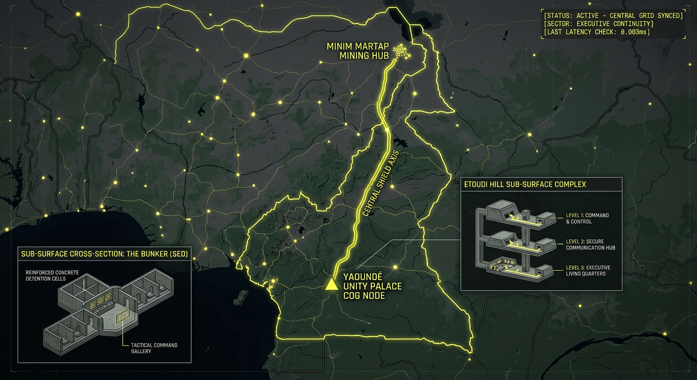
2026 Intelligence map overlay for Cameroon. This high-resolution visualization captures the 'Central Shield Axis,' explicitly mapping the deep-strata connection between the Unity Palace COG hub in Yaoundé (GMA-26) and the Minim Martap industrial mining vaults (GHA-26). The detailed inset diagram illustrates the SED 'Bunker' tactical cells situated hidden beneath the urban surface, facilitating high-speed transition between natural shielding and maritime operations. Telemetry data confirms that both command continuity and executive continuity functions are fully active under the 2026 Global Grid protocols.
Cameroon Underground
“Beneath the Etoudi Hill in Yaoundé and the deep bauxite veins of Minim Martap, the ‘Central Shield’ is active. Cameroon isn’t just a regional power; it’s a hardened ‘Executive Anchor’ where 1980s modernist bunkers meet the ultra-secure mining conduits of the 2026 Global Grid.”
The Cameroon Underground is a masterclass in centralized defense. While the world watches the surface politics, 2026 geospatial intelligence reveals a “Bunker” system in the capital designed for total institutional survival and a new industrial spine in the north capable of high-hardness asset caching. This report decodes the secret vaults of Unity Palace and the tactical galleries of the SED—where the line between administrative power and absolute security is buried in the concrete.
Location: Secretariat d’Etat à la Défense (SED) – “The Bunker,” Yaoundé
Functions: Tactical Military Command; High-Security Detention; SIGINT Interrogation Hub.
Composed of: Reinforced concrete basement cells; damp, lightless galleries; heavy blast-door partitioning.
Levels: 2–3 (Sub-surface).
Tunnels to: Secure transport links to the nearby military headquarters and Gendarmerie barracks.
Notes: Nicknamed “The Bunker,” the SED basement is a notorious high-hardness facility in the heart of Yaoundé. In 2026, it remains a primary node for the “Anglophone Crisis” operations, housing specialized units for interrogation and surveillance. Forensics indicate it is a “Dark Node” where surface noise is heavily suppressed for sensitive electronic and physical operations.
Source: Emmanuel Freudenthal – 2026 Human Rights & Tactical Survey.
Location: Palais de l’Unité (Unity Palace / Etoudi Palace), Yaoundé
Functions: Presidential COG (Continuity of Government); Strategic Executive Vault; Hardened Ingress/Egress.
Composed of: Subterranean bunkers designed by Olivier-Clément Cacoub; reinforced modernist concrete foundations; independent life-support and communications.
Levels: 3+ (Deep hill-penetration).
Tunnels to: Secret egress routes leading from the Etoudi Hill toward the military airfield.
Notes: Constructed on ancestral Etoudi land, the palace has served as a functional bunker during several historical coup attempts, notably in 1984. 2026 intelligence confirms that the sub-surface levels have been modernized to host a permanent Balkan-style signal relay and a dedicated executive survival suite, ensuring state continuity even during maximum urban unrest.
Source: Apsaidal Architectural Intelligence – 2026 Sovereign Site Survey.
Location: Minim Martap Industrial Conduits (Adamaoua Region)
Functions: High-Volume Resource Logistics; Potential Asset Caching; Hardened Mining Infrastructure.
Composed of: Advanced bauxite mining galleries; Inland Rail Facility (IRF) sub-strata links; reinforced drainage and storage vaults.
Levels: 2 (Mining-grade voids).
Tunnels to: Integrated rail-to-port conduits leading toward the Port of Douala.
Notes: As of February 2026, the Minim Martap project has reached operational status. While primarily industrial, the “Mine-to-Port” logistics strategy includes hardened storage areas and subterranean transport facilities designed to de-risk the export of high-grade bauxite. These sites are identified as “Dual-Use” nodes, where large-scale equipment can be cached away from satellite surveillance.
Source: Fidelity Investments / Canyon Resources – 2026 Industrial Update.
Location:
Functions: Unknown
Composed of: Unknown
Levels: Unknown
Tunnels to: Unknown
Notes:
Source:
🕳️ Intelligence Submission: Cameroon Underground
TERMINAL NOTICE: CENTRAL SHIELD GRID ACTIVE
The Cameroon Underground is a vital Executive & Industrial Node. If you have witnessed “unexplained sub-surface construction” near the Etoudi perimeter or recorded “rhythmic industrial pulses” from the Adamaoua rail facilities, your report is required for the 2026 Global Grid.
[SUBMIT YOUR CAMEROON UNDERGROUND SIGHTING TO THE SIGHTINGS FORM]
“In Yaoundé, the bunker holds the secrets of the state. In Minim Martap, the mountain holds the future of the grid.”