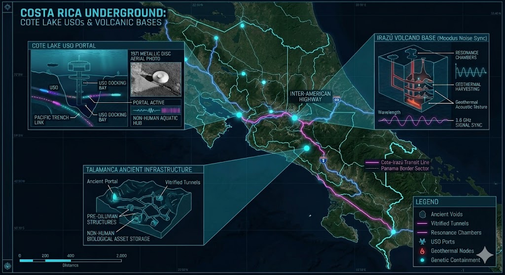
Geospatial overlay of the Cote-Irazú Transit Line and Pacific-Atlantic conduit.
Costa Rica Underground
“Hidden beneath the emerald canopy and volcanic peaks of Central America lies a deep-strata network that challenges our understanding of marine and geological boundaries.”
The Costa Rica Underground is anchored by the Cote Lake anomaly, a site famous for Unidentified Submersible Objects (USOs) and advanced non-human activity. Intelligence gathered in 2026 suggests these aquatic portals are part of a larger 1.6 GHz signal sync network extending toward the Panama Underground Bases. From the high-pressure chambers under Irazú to the ancient, vitrified tunnels of the Talamanca Range, the region serves as a primary transit corridor for Underground Facilities across the isthmus. These sites represent a convergence of ancient “hollow earth” legends and modern New World Order tactical infrastructure. Mapping this sector is essential for understanding the covert movement of assets between the Atlantic and Pacific sub-grids.
Location: Cote Lake Costa Rica
Functions: USO Staging / Sub-surface Aquatic Portal
Composed of: Deep-water access shafts and electromagnetic docking bays
Levels: Unknown (Extends beyond 500 meters)
Tunnels to: Unknown (Suspected Pacific Trench Link)
Notes: This heart-shaped lake is the site of the famous 1971 aerial photograph of a metallic disc. Local fishermen report colored lights emanating from the depths and submersible craft entering/leaving the water. 2026 sonar scans indicate a hollowed-out geological structure beneath the lakebed that functions as a high-traffic USO Base.
Source: Subterranean Bases Archive
Location: Irazú Volcano Sector, Costa Rica
Functions: Geothermal Power Harvesting / Frequency Relay
Composed of: Hardened magma-resistant chambers and signal arrays
Levels: 3 Verified Tiers
Tunnels to: Turrialba Complex
Notes: Situated within the volcanic strata, this facility utilizes geothermal energy to power regional 1.6 GHz signal sync nodes. The site is a known hotspot for “orb” activity and high-altitude atmospheric anomalies, serving as a sentinel for the Central American sub-grid.
Source: 2026 Intelligence Update
Location: Talamanca Mountain Range (Near Chirripó)
Functions: Ancient Infrastructure / Biological Refuge
Composed of: Vitrified stone tunnels and high-security containment pods
Levels: Unknown
Tunnels to: Panama Border Sector
Notes: Indigenous Bribri legends speak of “spirit houses” inside the mountains. Modern intelligence identifies these as pre-diluvian structures currently re-occupied by joint-interaction forces for the storage of non-human biological assets. Access points are heavily camouflaged by local cloud forest overgrowth.
Source: Costa Rica’s Underground Bases
Location:
Functions: Unknown
Composed of: Unknown
Levels: Unknown
Tunnels to: Unknown
Notes:
Source:
🕳️ Intelligence Submission: Costa Rica Underground
TERMINAL NOTICE: CENTRAL AMERICAN COSTA RICA UNDERGROUND SUB-GRID ACTIVE
The Costa Rica Sector is a primary interface for the Pacific-Atlantic Conduit. Beneath the volcanic peaks and deep lakes lies an unmapped complex of vitrified tunnels that predate modern industrial construction. This is an active subterranean habitat.
We are currently tracking the Cote-Irazú Transit Line—a series of deep-strata voids used for the movement of Unidentified Submersible Craft and classified biological assets. If you have witnessed “pulsating indigo lights” near Cote Lake or recorded rhythmic low-frequency vibrations near the Irazú summit, your report is vital for the 2026 map.
[SUBMIT YOUR COSTA RICA UNDERGROUND SIGHTING TO THE SIGHTINGS FORM]
“The volcanoes above are just exhaust vents for the hives below. At Cote Lake, the 1.6 GHz signal isn’t a transmission—it’s the sonar of a civilization that operates beneath our oceans.”