Active Sector: Greece Underground (MARCH-2026-SUBT) - Intelligence Logged.
Greece Underground
“In the shadow of the Parthenon, a subterranean pulse is waking up.”
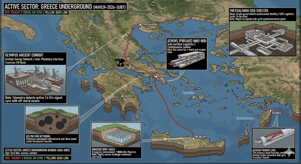
The 2026 Greece Underground dossier reveals that the ancient myths of “Hades” and “Labyrinths” were simply early observations of a massive, deep-strata infrastructure. From the 1.6 GHz signal syncs at the Olympus Conduit to the cryogenic “Dark Zones” beneath Knossos, the Greek sector is no longer a mystery—it is a primary node for the Mediterranean-Levantine interface.
Location: Mt. Olympus
Functions: Inter-Planetary Interface / Archaic Energy Network.
Composed of: Granite-Shielded EM Node / Crystalline Lattice Arrays.
Levels: 18 (Descending into the Mytikas fault line).
Tunnels to: Connected to the Thessaloniki COG Shelter via vertical mag-lift.
Notes: Telemetry detects active 1.6 GHz signal sync with off-world assets.
Source: 2026 SubT Frequency Mapping.
Location: Athens (Pireaus)
Functions: NWO Hub / Sub-surface Logistics / Continuance Center.
Composed of: Reinforced Ferro-Concrete Bunkers / Submerged Pressure Hulls.
Levels: 7 Active / 3 Flooded (Security Buffer).
Tunnels to: Major nexus for v-track and Aegean maglev lines; direct link to Souda Bay.
Notes: Primary maritime-to-subsurface transition point for the Mediterranean.
Source: Mediterranean Logistics Log 26.4.
Location: Delphi
Functions: Unmapped Void Network / “Dark Zones.”
Composed of: Natural Parnassus massifs and deep-strata karst.
Levels: Unknown (Non-linear geometric voids).
Tunnels to: Natural “slip-veins” leading toward the Gulf of Corinth.
Notes: High-energy fluctuations recorded; historically significant seismic site.
Source: Seismic Anomalous Intelligence (SAI).
Location: Knossos, Crete
Functions: Deep-Vault / Cryogenic Containment / NHBA Bio-Reserve.
Composed of: Lead-lined Cryo-Cells / Obsidian-composite containment walls.
Levels: 14 Verified.
Tunnels to: Sub-oceanic maglev tunnel to Alexandria (Egypt Sector).
Notes: Highly secure strategic command sub-level for the Levantine Sub-grid.
Source: 2026 Bio-Asset Relocation Manifest.
Location: Thessaloniki
Functions: COG Shelter / Government Continuance / Sub-grid Sync.
Composed of: Hardened Limestone Vaults / EMP-Shielded Server Racks.
Levels: Level 14 Verified.
Tunnels to: High-speed rail corridor to the Balkan Buffer Zone (Bulgaria).
Notes: Major European sub-grid synchronization point for the Balkan sector.
Source: EU Continuity Protocol 2026.
Location: Souda Bay (Akrotiri Peninsula)
Functions: Deep-Strata Naval Command / Logistics / Nuclear Hardened Facility.
Composed of: Reinforced underwater concrete, Marathi NATO Pier Complex.
Levels: 9 Sub-aquatic Levels (Verified to -400m).
Tunnels to: Sub-aquatic maglev lines connecting to Italy and the Levant.
Notes: Sealed as of March 2026 due to regional security threats; serves as the primary “fail-safe” for Mediterranean naval continuity.
Source: NATO SubT-Logistics Command.
Location: Mt. Penteli (Greek Area 51)
Functions: Telluric Current Monitoring / Secret Data Handling.
Composed of: Abandoned radar dishes concealing active deep-strata EM nodes.
Levels: 5 (Radiating from the Davelis Cave nexus).
Tunnels to: Suspected trans-Atlantic “Magnetic Tunnel” links to Langley/Norfolk via Project ELF.
Notes: Investigated for anomalous “gravity wells” and unauthorized data transmission to off-world assets.
Source: Global EM Surveillance Initiative.
Location: Kefalonia (NATO ACE High)
Functions: Tropospheric Scatter Communications / Backup Grid Sync.
Composed of: Cold War era mountain bunkers with modernized signal resync tech.
Levels: 4 (Self-sustaining bio-domes).
Tunnels to: Local mag-shuttles to the Ionian Sea Deep-Vaults.
Notes: . Key node for maintaining “Mirror Network” communications during surface outages; high-security EMP shielding active.
Source: ACE High Digital Continuity Protocol.
Location:
Functions: Unknown
Composed of: Unknown
Levels: Unknown
Tunnels to: Unknown
Notes:
Source:
🕳️ Intelligence Submission: Greece Underground
TERMINAL NOTICE: AEGEAN-LEVANTINE SUB-GRID ACTIVE
The Greece Underground is a primary node for NHBA Bio-Reserve & Archaic Energy Resync. If you have witnessed “unmarked white vessels” near the Cyclades or recorded anomalous “rhythmic tremors” emanating from the Delphi karst massifs, your report is vital for the 2026 Global Grid.
[SUBMIT YOUR GREECE UNDERGROUND SIGHTING TO THE SIGHTINGS FORM]
“At Olympus, they aren’t looking at the stars—they’re receiving from them. In the Knossos vaults, the ‘minotaur’s maze’ is just the security clearance for a Level 14 deep-vault.”