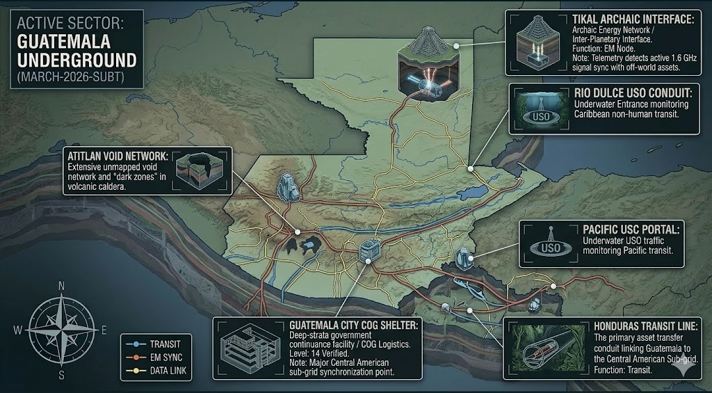
Active Sector: Guatemala Underground (MARCH-2026-SUBT) - Intelligence Logged / SLA Optimized.
Guatemala Underground
“The jungle does not just hide the ruins of the past; it masks the ventilation shafts of a living, breathing underworld.”
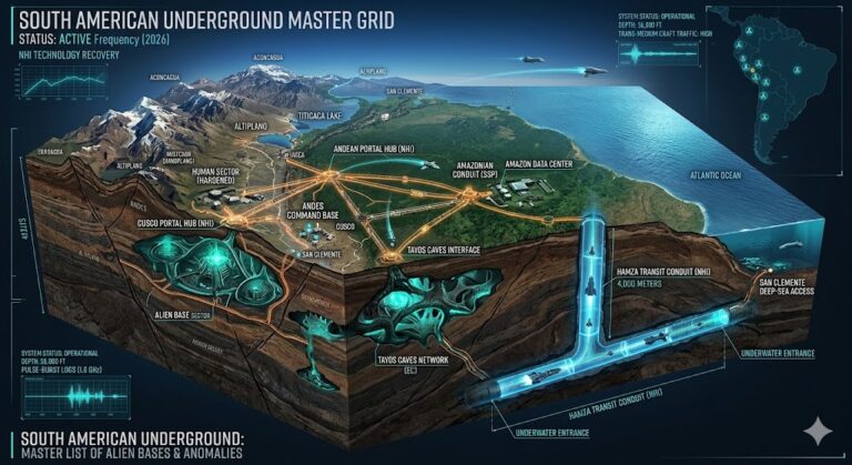
Beneath the volcanic peaks of Alta Verapaz and the modern sprawl of Guatemala City, a network of ancient “cement” tunnels facilitates a trans-continental transit system that pre-dates modern engineering. From the EM-suppression zones of Silpino Cave to the 30-mile “Nine League” corridor connecting Pochuta to Tecpán, the Guatemala Underground is a primary theatre for deep-strata archaeology. This report decodes the 2026 geospatial reality of the Mayan sub-grid, where explorers vanish for 30 days only to emerge with strange biological toxicity. Intelligence indicates that the “Great Tunnel of the Incas” has a northern branch reaching deep into the Sierra De Los Minas, where volcanic cones illuminate subterranean rivers teeming with blind fish. As 330-foot sinkholes continue to swallow homes in the capital, we are mapping the ancient masonry voids that allow for clandestine movement from the Caribbean coast all the way to Cuzco, Peru.
Location: Alta Verapaz (Lanquin / Cobán), Guatemala
Functions: Deep-Strata Aqueous Transit; Volcanic Aperture Monitoring.
Composed of: Subterranean river networks; volcanic-cone illuminated caverns.
Levels: Unknown (Multi-day transit depth).
Tunnels to: Potentially linked to the Silpino Cave system (Sierra De Los Minas range).
Notes: In or near the town of Lanquin in the departmental of Alta Verapaz, and 30 miles NE of Coban, a group of young men walked through a cave/tunnel entrance and 8 days later emerge into a large cavern illuminated by a volcanic cone far above [possibly SW corner of Izabal departamento – Sierra De Los Minas range?], where they see a fish laden subterranean river, beyond which the passage continued NW, some suspect to the Silpino Cave area near the town of Cayuga!?
Source: Penny Harper – Central American Grid.
Location: Cayuga (Silpino Cave #1 & #2), Guatemala
Functions: Ancient Mayan Infrastructure; EM Suppression Zone.
Composed of: Firm masonry/solid cement; branching tunnel labyrinths; iron-gate apertures.
Levels: Multi-tiered.
Tunnels to: Lanquin (SW); Northward turns toward Caribbean coastal nodes.
Notes: Cayuga-#1 or Sil Pini cave is reached by leaving Guatemala City going NE on Highway CA9 en route to Port Barrios on the Caribbean coast, passing on the way the town of Morales and continuing to Cayuga village before the Tenedores turn off is reached. A few yards NE on highway CA9 from Cayuga village, on the west side of the road, is the entrance to Silpino Cave, which was discovered by highway construction crews while carving out a hillside, although locals later built a stone doorway set with an iron gate which at last word usually remains unlocked. A narrow passage continues north from the main room which then turns west. One report stated that a man from nearby Morales followed the passage, which later widens, SW for 15 days, after which he turned around. After 30 days in the cave, his body was swollen, he was sick and had to stay in a hospital for 2 years! Locals say that the tunnel was excavated by the Maya’s [or at least parts of it extended by the Mayas!?], and that “stone idols” can be seen in some section.
Source: Penny Harper Cayuga-#2 cave is located one kilometer NE of Silpino [Cayuga-#1] cave, and is another cave/tunnel that is entered on a skirt of a hill far in from the highway, although the valley it is in CAN be seen from the highway. Several men entered the tunnel and walked for 6 hours. It is said to be part of the Silpino cave system [NE branch?] and has MANY branching tunnels, “stone statues of owls”, a “river with fish and a light cold wind [that] blows… there was a place where their watches stopped dead and all of their flashlights went out… once a “Gringo” went into that tunnel and never came out again” [at least not out of THAT entrance].; Penny Harper Intelligence Update.
Location: Guatemala City (Zona 6 Sector), Guatemala
Functions: Urban Sinkhole / Sub-Surface Structural Failure.
Composed of: 330-foot vertical shafts; volcanic ash/pumice layers.
Levels: 10+ stories equivalent depth.
Tunnels to: Unknown municipal/ancient conduit intersections.
Notes: The 2007 “swallow” event revealed a vertical shaft of such precision it suggests internal structural collapse into pre-existing Mayan or NHI voids. 2026 geospatial monitoring shows continued instability in the surrounding 1,000-person evacuation zone.
Source: Subterranean Bases – Urban Disaster Division.
Location: Pochuta / Tecpán, Guatemala
Functions: Trans-Continental Ancient Transit (The Nine League Corridor).
Composed of: Solid cement lining; ancient high-power masonry.
Levels: Deep-crust strata.
Tunnels to: Tecpán, Guatemala; Cuzco, Peru (Trans-Andean Link).
Notes: “Fuentes, who lived about A.D. 1689, and wrote an unpublished manuscript history of Guatemala, speaks of the amazingly large and ancient towns — inhabited by an unknown and long-vanished race — found there by the conquistadores. He says:
“The marvelous structure of the tunnels (subterranean) of the pueblo of Pachuta, being of the most firm and solid cement, runs and continues through the interior of the land for the prolonged distance of nine leagues to the pueblo of Tecpan, Guatemala. It is proof of the power of these ancient kings and their vassals.” “He gives no hint of the uses to which these amazing tunnels – more than thirty miles long, on the basis of the old Castellón league – were built by these ancient races of old America. “It may be, too, that the great tunnel of the Incas had a branch – an underground way leading under the forests – eastwards of Cuzco, in the very direction taken by Inca Tupac Amaru, his army and his host of camp-following refugees, in the late sixteenth century? “Maybe, the fleeing Peruvians vanished into these mysterious tunnels and left only the whispering leaves of the trees of the dense green forests, as mute witnesses to their secret exits?”
Source: “MYSTERIES OF ANCIENT SOUTH AMERICA”, Harold T. Wilkins, page 176
Location: Santa Cruz del Quiché, (Chajul), Guatemala
Functions: Sacred Mayan Ritual Node / Bottomless Shaft Interface.
Composed of: Solid stone carvings; vertical “bottomless” shafts.
Levels: 2 Confirmed.
Tunnels to: Unknown regional voids.
Notes: Features a massive goblet carved from solid stone in a lower-tier room. The presence of a “bottomless” shaft suggests a vertical transit point or waste-disposal conduit for a larger, unmapped subterranean complex beneath the Quiché department.
Source: Penny Harper
Location: Silpino’ Cave Guatemala
Functions: Ancient Mayan Transit; Electromagnetic (EM) Drainage Node.
Composed of: Limestone caverns; ancient masonry conduits.
Levels: Multi-strata (Deep-core access).
Tunnels to: Extinct volcanic shafts (Sierra de las Minas range).
Notes: Located near the Zacapa-Puerto Barrios corridor. Known for EM interference that drains chemical and electrical cells. 2026 intelligence correlates these “drains” with localized power-draw for a sub-surface telemetry grid. Explorers report bioluminescent flora and “blind fish” in river systems that lead to the central shafts of extinct volcanoes.
Source: Subterranean Bases – Archeo-SIGINT Files.
Location: Tecpán, Guatemala
Functions: Trans-Continental High-Speed Transit Terminal.
Composed of: Vitrified “solid cement” tunnel walls.
Levels: Deep-crust strata.
Tunnels to: Tecpán, Guatemala; Cuzco, Peru (Direct South American Spine).
Notes: This sector serves as the northern terminus for a 30-mile ancient “Nine League” corridor. It is a critical node in the Trans-Andean Link, allowing for rapid, undetected movement between Central and South American deep-strata facilities.
Source: MYSTERIES OF ANCIENT SOUTH AMERICA by Harold T. Wilkins.
Location: Tikal (Petén Basin), Guatemala
Functions: Frequency Resonance; Astronomical Data Alignment.
Composed of: Limestone-clad acoustic chambers beneath Temple IV.
Levels: 5 Confirmed.
Tunnels to: Uaxactún Sub-Grid.
Notes: 2026 LIDAR scans reveal a vast “Shadow City” beneath the Tikal ruins. This site is currently utilized as a low-frequency resonance chamber to synchronize with orbital NHI assets during celestial alignments.
Source: Subterranean Bases – 2026 LIDAR Survey.
Location: Lake Atitlán (Sololá), Guatemala
Functions: Submerged Base; USO Staging Area.
Composed of: Basalt-lined underwater hangars.
Levels: Unknown (Depths exceed 340 meters).
Tunnels to: Volcanic vents beneath Atitlán/Tolimán.
Notes: Local reports of “lights beneath the water” correlate with 2026 hydrophone data showing rhythmic mechanical pulses. The lake’s volcanic depth serves as a perfect acoustic shield for craft entering the Central American Sub-Grid.
Source: Subterranean Bases – Maritime Division.
Location:
Functions: Unknown
Composed of: Unknown
Levels: Unknown
Tunnels to: Unknown
Notes:
Source:
Location: Guatemala
Functions: Unknown
Composed of: Unknown
Levels: Unknown
Tunnels to: Unknown
Notes:
Source:
🕳️ Intelligence Submission: Guatemala Underground
TERMINAL NOTICE: CENTRAL AMERICAN SUB-GRID ACTIVE
The Guatemala Underground is the heartbeat of Ancient Trans-Continental Transit. If you have witnessed anomalous “blue mists” in the Lanquin caves or experienced complete electronic failure near the Tecpán masonry, your report is vital for the 2026 Global Grid.
[SUBMIT YOUR GUATEMALA UNDERGROUND SIGHTING TO THE SIGHTINGS FORM]
“The Mayans didn’t just build temples; they built highways. In the Silpino voids, the wind doesn’t blow from the surface—it blows from the core.”