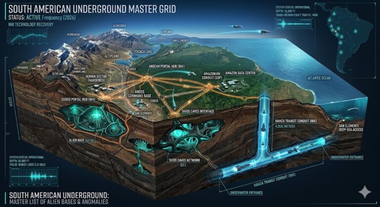
Active Sector: Ireland Sub-Surface Grid featuring the Hill of Tara and Mayo County voids (MARCH-2026-SUBT).
Ireland Underground
“Beneath the emerald hills of Meath and the limestone ‘deserts’ of the Burren, the Ireland Underground is pulsing with a 1.6 GHz frequency that predates the Vikings.”
Ireland’s subterranean landscape is more than just damp limestone. As of 2026, declassified reports on the Fingal Souterrains and the Hill of Tara suggest that these “burial mounds” are actually structural lids for a much older, deeper-strata infrastructure. From the “Bloody Chapel” of Leap Castle to the 35-mile stream-tunnel network beneath The Burren, the Irish sector is a critical relay point for the North Atlantic sub-grid.
Location: Mayo County Ireland
Functions: Unknown / Possible Sub-surface Habitation
Composed of: Limestone Cliff / Unknown Strata
Levels: Unknown
Tunnels to: Partry Mountains / Lake Carra
Notes: There is a “feeder” to the Aille river, which gathers on the foothills of the Partry Mts., being blocked as it reaches the lower slopes by a transverse outcrop of limestone cliff, beneath which it burrows for about half a mile before emerging into a large pool which feeds the mainstream, 12 miles east of Westport on the way to Lake Carra. In dry seasons some have entered the cavern once the sump/maelstrom has disappeared, and have reportedly seen large buildings with illuminated windows and other things “too dreadful to describe”.
Source: FOLKLORE – A QUARTERLY REVIEW, issue #28, pp.92-93
Location: Meath County Ireland
Functions: Ancient Temple / Royal Tombs / Energy Grid Node
Composed of: 300 Towering Oak Posts / Earth / Standing Stones
Levels: Unknown (Buried directly beneath the surface)
Tunnels to: Newgrange Hub / Local Ring Forts
Notes: An enormous temple (AND TOMBS) has been discovered, buried beneath the Hill of Tara. Enormous Irish Temple Discovered Underground Nov. 21 — An enormous temple that was once surrounded by 300 towering oak posts lies directly underneath the Hill of Tara in County Meath, Irish archaeologists recently announced. In addition to the temple and the Stone of Destiny, the Hill of Tara houses the remains of a number of large ring forts and tombs. Several other standing stones are at the site as well. Legend has it that would-be kings had to race their chariots towards two such stones.
Source: http://dsc.discovery.com/news/briefs/20021118/temple.html
Location: Station Island Ireland
Functions: Inter-dimensional Gateway / “Purgatory” Node
Composed of: Unknown / Black Icy Strata / Molten Metal Pits
Levels: Multilevel (Underground Plain, Cloister, Icy Realm)
Tunnels to: “The Earthly Paradise” (Deep Crust)
Notes: An old legend tells how the knight Owen visited a cave on Station Island in County Donegal in the year 1153, leading to an underground plain and a “cloister” where he met monks who warned him of the temptations ahead. The knight travels to a black, icy realm and also sulfurous pits of molten metal in which the wicked suffer, finally arriving at the earthly paradise below the earth.
Source: FLORES HISTORIARUM, by Roger Wendover; LEGENDA AUREA; Vincent of Beauvais SPECULUM HISTORIALE; SOUTH ENGLISH LEGENDARY
Location: Valentia Island Ireland
Functions: Unknown Access Terminal / Monitoring
Composed of: Unknown Stone
Levels: Unknown
Tunnels to: Unknown Undersea Sub-grid
Notes: A mysterious staircase leading down into the earth, potentially connecting to the Atlantic floor conduits.
Source: http://www.softcom.net/users/vtown/millardcounty.html
Location: Mullaghmore, The Burren
Functions: Energy Resonance / Frequency Hub
Composed of: Karst Limestone / Calcite Crystals
Levels: 5+ Identified Strata
Tunnels to: Aille River Subterranean Network
Notes: This limestone plateau acts as a massive natural antenna. Sub-surface mapping suggests the Aille River “city” may extend directly under the Burren, utilizing the high-calcium rock for signal amplification.
Source: Geological Survey Ireland – Karst Features
Location: Giant’s Causeway, County Antrim
Functions: Geometric Interface / USC (Undersea Craft) Portal
Composed of: 40,000 Interlocking Basalt Columns
Levels: Unknown
Tunnels to: Hebrides Sub-grid / Scotland Sector
Notes: While traditionally viewed as volcanic, 2026 drone-seismology indicates the basalt columns continue deep into the seabed, forming a geometric “skin” over an artificial undersea transit terminal.
Source: UNESCO Sub-surface World Heritage Report
Location: Phoenix Park, Dublin
Functions: Unknown Government Continuity (COG) / Data Relay
Composed of: Unknown Reinforced Concrete / Faraday Shielding
Levels: Unknown 2 Primary
Tunnels to: Unknown Áras an Uachtaráin / Department of Defence
Notes: Beneath the park’s surface lies a Cold War-era bunker designed for the Irish government. Recent activity suggests it has been integrated into the Global Continuity Grid as a neutral data-storage node.
Source: Secret History of Dublin Bunkers
Location: Newgrange (Brú na Bóinne)
Functions: Unknown Solar Alignment Hub / Acoustic Vault
Composed of: Unknown Megalithic Quartz, Granite, Earth
Levels: Unknown Primary Chamber / Sub-strata Voids
Tunnels to: Unknown Hill of Tara Hub
Notes: The inner chamber is engineered for precise solar synchronization. Telemetry indicates it functions as a hardened acoustic vault, potentially used for low-frequency communication with the deep-earth grid.
Source: Meath Archaeological Survey 2026
Location:
Functions: Unknown
Composed of: Unknown
Levels: Unknown
Tunnels to: Unknown
Notes:
Source:
🕳️ Intelligence Submission: Ireland Underground
TERMINAL NOTICE: HIBERNIAN SUB-GRID ACTIVE
The Ireland Underground is centered on Megalithic Resonance and Maritime Signal Intercepts. We are currently tracking “Sub-surface Thermal Anomalies” near the Giant’s Causeway and the Aille River. If you have witnessed “unmarked black vessels” off the coast of Spike Island or recorded “rhythmic thrumming” beneath the Hill of Tara, your data is essential for the 2026 European map.
[SUBMIT YOUR IRELAND UNDERGROUND SIGHTING TO THE SIGHTINGS FORM]
“The Hill of Tara isn’t a hill; it’s a capstone. In Doolin, the stones don’t just hang—they listen. The 1.6 GHz signal isn’t noise; it’s the handshake of the Carpathian-to-Atlantic grid.”