Louisiana Underground
“Beneath the cypress swamps and shifting bayous of the Gulf Coast lies a salt-cured secret—a network of imperial domes and ‘unknown’ military silos that didn’t just survive Katrina; they thrived in the chaos.”
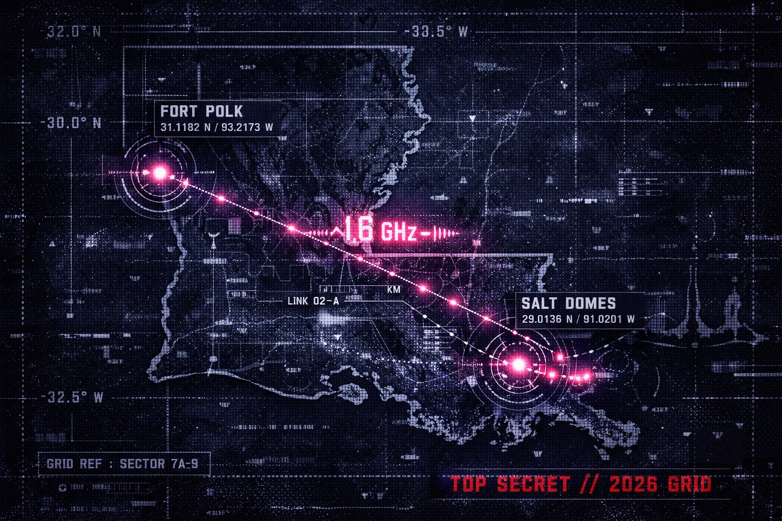
Beneath the restricted perimeter of Fort Polk and the ancient salt islands of the Iberia Parish, the Louisiana Underground is a high-priority anchor for the 2026 global grid. While the public focuses on the Strategic Petroleum Reserve, our archive highlights the “Anomalous Zones” within the Weeks Island mine, where vertical cylindrical pipes and high-pressure gas inclusions suggest a subterranean architecture far more complex than simple oil storage. From the 1,000-foot “Underground City” of Avery Island to the secret metropolitan tunnels of New Orleans—where 2026 sensors have picked up the signature 1.6 GHz frequency sync—this sector serves as a massive logistics hub for both Continuity of Government (COG) and suspected Non-Human Intelligence (NHI) transit. Recent reports of unmapped UN troop movements and “ghost boats” appearing in the city’s drainage sub-grid confirm that Louisiana’s hollowed-out strata is an active resonator for the 2026 global synchronization.
Location: Fort Polk (Fort Johnson), Louisiana
Functions: Joint Readiness Training Center (JRTC) / Suspected UN Logistics Hub
Composed of: Unknown (Massive reinforced subterranean storage)
Levels: Unknown
Tunnels to: Unknown
Notes: Reports from former personnel describe “war-ready” UN Organization troops (French, Pakistani, Russian) and vast underground supply depots. Officially renamed Fort Johnson in 2023, but restored to Fort Polk in 2025.
Source: a former anonymous serviceman who interacted with the base; JRTC History
Location: New Orleans Sub-Grid, Louisiana
Functions: (Urban Continuity / Drainage Interface)
Composed of: Concrete and industrial debris
Levels: Multi-layered drainage and utility tunnels
Tunnels to: Michoud Assembly Facility (NASA)
Notes: M Post-Katrina “rabbit holes” include reports of people vanishing into drainage canals and unmapped “Ghost Boats” found in deep pipes. Heavy talk of targeted break-ins at medical facilities for non-narcotic specific documentation during the 2005 event.
Source: Reddit Archive: Katrina Rabbit Holes
Location: Weeks Island Salt Dome, Iberia Parish, Louisiana
Functions: Strategic Petroleum Reserve (SPR) / Decommissioned Mine
Composed of: Domal Salt / “Black Salt” Anomalies
Levels: Two-tiered room-and-pillar mine (152m and 213m depth)
Tunnels to: Regional Pipeline Arterials
Notes: Contains “Anomalous Zones” with vertical cylindrical pipes exceeding 100 meters. Geotechnical reports cite “blowouts” and gas inclusions under high pressure. Sinkholes appearing over the mine edges suggest ongoing dissolution or structural tampering.
Source: OSTI: Salt Dissolution Sinkholes
Location: Avery Island “Underground City”, Iberia Parish, Louisiana
Functions: Commercial Salt Mining / Tabasco Storage
Composed of: 99% Pure Rock Salt
Levels: Main shaft at 1,000 feet (completed 1973)
Tunnels to: Unknown
Notes: Known as the “Underground City of Salt.” Historically a strategic Confederate resource, now a massive industrial void within the highest point on the Gulf Coast. Suspected proximity to the 1.6 GHz signal sync reported at other coastal domes.
Source: AAPG: Geology of Avery Island
Location: Sulphur Mines Salt Dome (Cavern 2-4-5), Westlake, Louisiana
Functions: Unknown (Suspected Energy Dissipation / Pressure Sink)
Composed of: Conjoined Salt Caverns
Levels: Unknown
Tunnels to: Regional Industrial Sub-Grid
Notes: As of March 2026, this cluster is under a State of Emergency due to “unexplained pressure loss.” Regulators report the cavern is losing “a couple of pounds a day” without a visible leak, suggesting a bleed-off into a deeper, unmapped void or transit conduit.
Source: American Press: Sulphur Mines Emergency
Location: Cote Blanche Island Mine, St. Mary Parish, Louisiana
Functions: Unknown (Metamorphic Salt Research / Logistics)
Composed of: Poikiloblastic Salt (Small crystals embedded in metacrysts)
Levels: 1,500 feet deep
Tunnels to: Intracoastal Waterway Sub-ingress
Notes: Unique “anomalous salt” textures (unusually coarse/friable) and reddish-brown sandstone beds that shouldn’t exist at these depths. Unlike other domes, this site shows no internal boundary zones, suggesting it is a single, massive “pulse” of upwelling material.
Source: Mining Data Online: Cote Blanche
Location: Michoud Assembly Facility (Sub-Levels), New Orleans East
Functions: Unknown (Aerospace-to-Subaquatic Transit)
Composed of: Reinforced Concrete / Pumping Arrays
Levels: Unknown (Extends below sea level)
Tunnels to: Lake Pontchartrain / Gulf Sub-ingress
Notes: During the 2005 event, the facility remained a functional “island” with active helipad operations. 2026 telemetry indicates it serves as a coordination hub for “Ghost Boats”—unmanned, freshly stocked vessels found drifting in the bayous without owners.
Source: Reddit: Katrina Rabbit Holes
Location: Barksdale AFB (Bossier City, Louisiana)
Functions: Global Strike Command / Nuclear Command & Control (NC3).
Composed of: Hardened silos; New 2026 Weapons Generation Facility (WGF).
Levels: 4 confirmed sub-strata (including the “Looking Glass” backup comms).
Tunnels to: Unknown
Notes: Serves as the primary 2026 hub for strategic deterrence. New high-security subterranean vaults have been completed to house the modernized B-52 avionics and tactical nuclear assets.
Source:
Location: Camp Beauregard (Pineville, Louisiana)
Functions: Louisiana National Guard HQ / Continuity of Government (COG).
Composed of: Hardened emergency operations centers (EOC).
Levels: 2 primary tiers + regional secure data storage.
Tunnels to: Unknown
Notes: Acts as the 2026 master node for the “GeauxGuard” infrastructure monitoring. Rumors of deep-level links to the Pineville industrial sub-grid persist.
Source:
Location: West Hackberry SPR Site (Cameron Parish, Louisiana)
Functions: Strategic Petroleum Reserve (SPR) / Large-Scale Hydrocarbon Storage.
Composed of: 22 massive salt caverns; reinforced pipeline manifolds.
Levels: Depths ranging from 2,000 to 4,000 feet.
Tunnels to: Unknown
Notes: Undergoing “Modernization Life Extension 2” (LE2) as of March 2026. Official reports cite cavern integrity work, but locals report high-frequency “metallic humming” from the deeper pump stations.
Source:
Location: Bayou Choctaw SPR Site (Iberville Parish, Louisiana)
Functions: Strategic Petroleum Reserve / Emergency Energy Supply.
Composed of: 6 operational salt caverns.
Levels: Unknown
Tunnels to: Connected via the Capline Pipeline System to regional refinery hubs.
Notes: Strategically positioned near the Mississippi River. Recent 2026 bypass construction suggests the addition of unmapped “emergency transit” conduits.
Source:
Location:
Functions: Unknown
Composed of: Unknown
Levels: Unknown
Tunnels to: Unknown
Notes:
Source:
🕳️ Intelligence Submission: Louisiana Underground
TERMINAL NOTICE: GULF COAST RESONANCE ACTIVE
The Louisiana Underground is a primary node for Salt-Dome Storage and Urban Continuity. If you have witnessed “unmarked military convoys” near the salt mines or recorded anomalous “metallic echoes” within the New Orleans drainage pipes, your report is vital for the 2026 Global Grid.
[SUBMIT YOUR LOUISIANA UNDERGROUND SIGHTING TO THE SIGHTINGS FORM]
“At Weeks Island, the sinkholes aren’t just gravity; they’re breathing. Beneath the Bayou, the ‘Strategic Reserve’ is just the cover story for a grid that has been pulsing since the salt first rose.”