Skip to content
Subterranean Bases

Subterranean Bases

What's under your feet!

Primary Menu
  • Home
  • Underground Bases: The Complete List
  • The Branton Papers
    • Index of Cave and Tunnel Entrances of the America’s
    • Project Redbook
    • The Project Superman: Andy Pero Story
    • The Dulce Papers
    • The Omega Files
  • Under the Ground
  • Hollow Earth
Light/Dark Button
  • Home
  • Underground Bases: The List
  • Oceania Underground
  • The Oceania Underground Master List
  • Oceania Underground

The Oceania Underground Master List

bretwalters6969
Tactical cross-section of the Oceania Underground, detailing the Pine Gap SIGINT Hub, New Zealand elite survival bunkers, and glowing blue Alien Bases in the Kermadec and Solomon Sea Trenches. Labeled 2026 Grid Update.

2026 Oceania Underground Master Grid. Mapping the Pine Gap SIGINT Hub and Deep-Trench Alien Bases (NHI) from the Great Dividing Range to the Kermadec Conduit. Grille maîtresse souterraine de l'Océanie 2026. Cartographie du hub SIGINT de Pine Gap et des bases extraterrestres (NHI) en fosse profonde, du Great Dividing Range au conduit de Kermadec.


Oceania Underground: 16-Nation Master Index


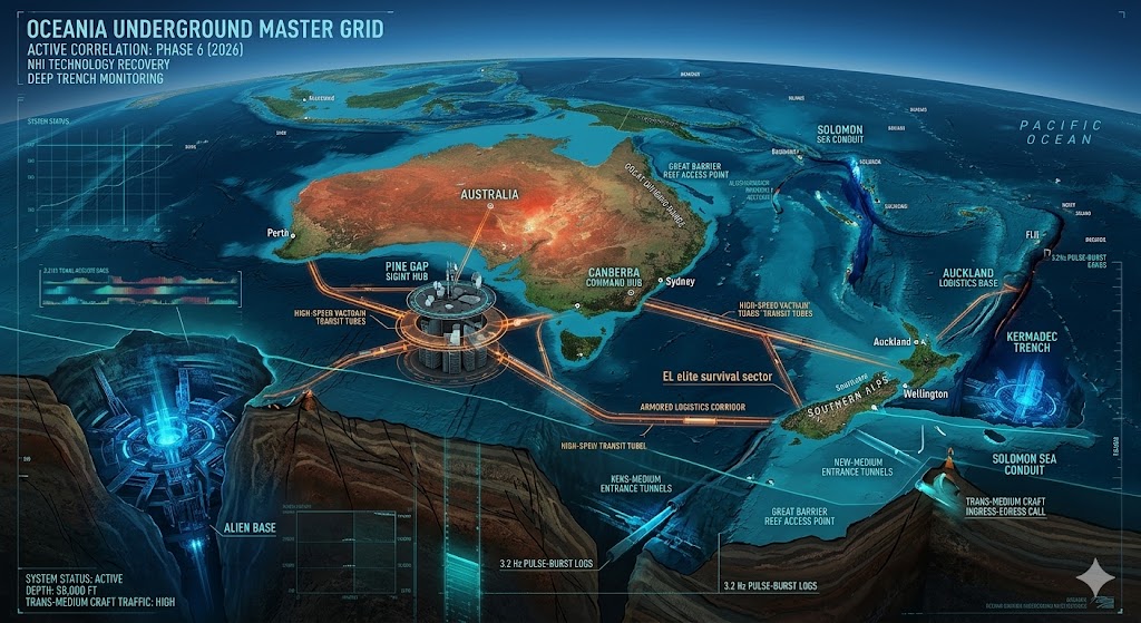
“The Oceania sub-grid is the primary ‘Silent Watcher’ of the southern hemisphere. Dominated by the Pine Gap intelligence complex in Australia and the billionaire ‘Hard-Sites’ in New Zealand, this 16-nation sector manages the most sophisticated deep-space and deep-ocean monitoring systems on the planet. Our 2026 data indicates that Alien Bases in the Solomon Sea and the Kermadec Trench serve as high-speed nodes for trans-medium craft.”

Primary Continent Hubs Melanesia & Micronesia Polynesia & Territories
Australia — [View Report] Papua New Guinea — [View] Samoa — Researching
New Zealand — [View Report] Fiji — [View] Tonga — Pending Data
Solomon Islands — [View] Vanuatu — [View] Tuvalu — Pending
Marshall Islands — Verifying Palau — [View] Nauru — Researching
Kiribati — Pending Micronesia — [View] Cook Islands — [View]
Guam (USA) — [View] American Samoa — [View] French Polynesia — [View]


🕳️ Intelligence Submission: Oceania Master List

TERMINAL NOTICE: OCEANIA SECTOR – DEEP TRENCH & SIGNAL INTELLIGENCE

The Oceania Underground is currently the primary focus of “Project Silent Horizon” (2026). Our sensors have tracked massive subterranean expansions at the Pine Gap (Australia) facility, which now appears to connect directly to the Kermadec Trench Alien Base. This sector is no longer just for SIGINT; it is a primary logistics corridor for NHI (Non-Human Intelligence) assets moving from the deep mantle to the upper atmosphere.

We are prioritizing intelligence regarding “Seismic Cavitation” signatures in the Great Dividing Range, unauthorized “Deep-Water” drilling near the Lord Howe Rise, and anomalous light-pillar events in the Southern Alps (NZ). If you have documentation of heavy military transport into unlisted mountain portals in Papua New Guinea or have intercepted low-frequency (3.2 Hz) pulses from the Mariana Trench floor, your report is vital.

[SUBMIT YOUR OCEANIA ALIEN BASE SIGHTING]

“In the Oceania Underground, the silence is engineered. Australia is the ear, New Zealand is the life-raft, and the islands are the eyes. Below the waves, the Alien Bases of the Pacific have been listening for a very long time.”

Share this post:

Share on X (Twitter) Share on Facebook Share on Email Share on Reddit Share on WhatsApp Share on Pocket Share on Telegram Share on Hatena Share on SMS Share on Bluesky
Tags: Pine Gap Underground DUMBs Australia New Zealand Bunkers Kermadec Trench NHI Pacific Mariana Trench Ufology Oceania Underground Polynésie Souterraine Alien Bases Ufologie Pacifique 2026 Global Grid Technologie Non Humaine Bases Extraterrestres

Post navigation

Previous: The Asian Underground Master List
Next: The Central American Underground Master List

You may have missed

Digital noir geospatial map of the Republic of the Congo showing the subterranean link between the Pointe-Noire data vaults and Brazzaville command node, with neon-magenta conduits.
  • Congo Underground

Congo Underground

bretwalters6969
Digital noir geospatial map of Comoros showing glowing neon-blue conduits connecting the Itsoundzou Command Node to the Hahaya Lava Vaults. Inset reveals a cross-section of a Tier-III data vault buried in volcanic rock.
  • Comoros Underground

Comoros Underground

bretwalters6969
Digital noir geospatial map of Chad showing the subterranean link between the Adji Kosseï command node and the Doba pipeline, with neon-cyan data conduits.
  • Chad Underground

Chad Underground

bretwalters6969
A dark geospatial map rendering of the Central African Republic in a digital noir aesthetic. Glowing neon-red conduits visualize the 2026 subterranean grid, linking the 'Berengo Command Node' (GMA-26) to the 'Ndassima Mining Hub' (GHA-26). Intelligence forensics indicate 'Camp de Roux' (GRA-26) is synchronized. Telemetry confirms real-time SIGINT synchronization across the Grey Zone sector.
  • Central African Republic Underground

Central African Republic Underground

bretwalters6969
  • Home
  • Tunnels & Caves
  • Alien’s & UFO’s
  • Hollow Earth
  • Under the Ground
  • Underground Bases: The List
Copyright © All rights reserved. | MoreNews by AF themes.