Skip to content
Subterranean Bases

Subterranean Bases

What's under your feet!

Primary Menu
  • Home
  • Underground Bases: The Complete List
  • The Branton Papers
    • Index of Cave and Tunnel Entrances of the America’s
    • Project Redbook
    • The Project Superman: Andy Pero Story
    • The Dulce Papers
    • The Omega Files
  • Under the Ground
  • Hollow Earth
Light/Dark Button
Bahrain Underground A dark geospatial map rendering of Bahrain in a digital noir aesthetic. Glowing neon-amber conduits visualize the 2026 subterranean Continuity of Operations grid, linking the 'Jebel ad Dukhan SIGINT Hub' (GMA-26) to the 'Juffair Naval USO Tracking Aperture' (GHA-26). Intelligence forensics indicate the geometric docking bays 150 feet below Juffair Harbor are active. Note the cinematic use of deep charcoal and neon-amber lighting with topographic data overlays. Telemetry confirms real-time SIGINT synchronization across the Persian Gulf sector.
  • Bahrain Underground

Bahrain Underground

bretwalters6969
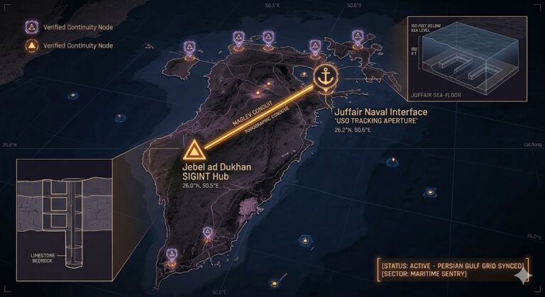
Bahrain Underground “Beneath the ‘Mountain of Smoke’ and the deep-water berths of Juffair, the Gulf is wired....
Read More Read more about Bahrain Underground
Azerbaijan Underground A dark, high-resolution geospatial map rendering of Azerbaijan in a digital noir aesthetic. Growing neon-amber conduits visualize the 2026 subterranean Continuity of Operations grid, linking the 'Gobustan Volcanic Aperture' (GMA-26) to the 'Baku Metro COG Shelter' (GHA-26). Intelligence forensics indicate the Faraday-shielded salt vaults in Duzdag (GRA-26) are synchronized. Telemetry confirms real-time SIGINT synchronization across the coastal and inland sector.
  • Azerbaijan Underground

Azerbaijan Underground

bretwalters6969
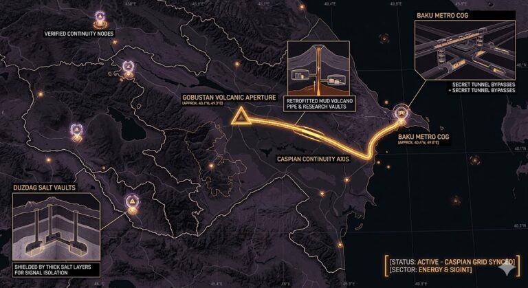
Azerbaijan Underground “Beneath the burning hills of Baku and the salt-crowned peaks of Nakhchivan, the Caspian is...
Read More Read more about Azerbaijan Underground
Armenia Underground A dark, high-resolution geospatial map rendering of Armenia in a digital noir aesthetic. Growing neon-amber conduits visualize the 2026 subterranean Continuity of Operations grid, linking the 'Mount Aragats Physics Hub' (GMA-26) to the 'Yerevan Metro COG Shelter' (GHA-26). Intelligence forensics indicate the ancient rock-cut vaults in Geghard (GRA-26) are synchronized for 1.6 GHz signal resonance. Telemetry confirms real-time SIGINT synchronization across the high-altitude sector
  • Armenia Underground

Armenia Underground

bretwalters6969
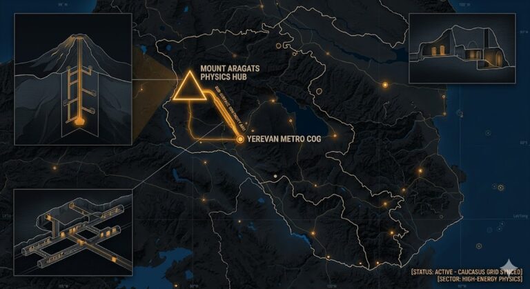
Armenia Underground “Between the cosmic ray shafts of Mount Aragats and the rock-cut silence of Geghard, Armenia...
Read More Read more about Armenia Underground
Antigua and Barbuda Underground A dark, high-resolution geospatial map rendering of Antigua and Barbuda in a digital noir aesthetic. Growing neon-amber conduits visualize the 2026 subterranean Continuity of Operations grid, linking the 'Mount Obama SIGINT Hub' (GMA-26) to the 'Barbuda Blue Holes USO Aperture' (GHA-26). Intelligence forensics indicate the historic English Harbour vaults in Shirley Heights (GRA-26) are synchronized. Telemetry confirms real-time SIGINT synchronization across the Caribbean sector.
  • Antigua and Barbuda Underground

Antigua and Barbuda Underground

bretwalters6969
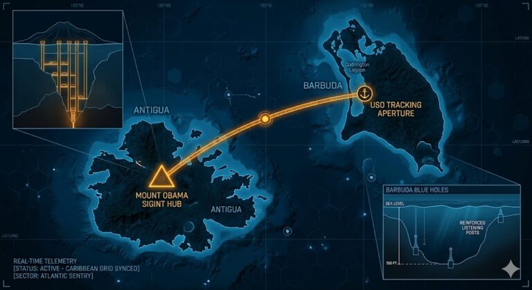
Antigua and Barbuda Underground “Beneath the turquoise waters and colonial ruins, the Caribbean has a hidden pulse....
Read More Read more about Antigua and Barbuda Underground
Angola Underground A dark, high-resolution geospatial map rendering of Angola in a digital noir aesthetic. Glowing neon-amber conduits visualize the 2026 subterranean Continuity of Operations grid, linking the 'Lunda Norte Diamond Vaults' (GMA-26) to the 'Kwanza Sul Cavern Hub' (GHA-26). Intelligence forensics indicate the UNITA Jamba Node (GRA-26) is synchronized. Telemetry confirms real-time SIGINT synchronization across the sub-jungle sector.
  • Angola Underground

Angola Underground

bretwalters6969
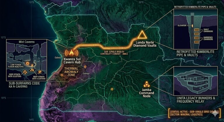
Angola Underground “Deep beneath the blood-diamond pipes of Lunda Norte, the earth is hiding more than carbon....
Read More Read more about Angola Underground
Andorra Underground A dark, high-resolution geospatial map rendering of the Principality of Andorra in a digital noir aesthetic. Growing neon-amber conduits visualize the 2026 subterranean Continuity of Operations grid, linking the 'Pic de Casamanya Portal Hub' (GMA-26) to the 'Arcalís Cryogenic Continuity Node' (GHA-26). Intelligence forensics indicate the multi-tiered Radio Andorra vaults in Encamp (GRA-26) are synchronized. Telemetry confirms real-time SIGINT synchronization across the high-altitude sector.
  • Andorra Underground

Andorra Underground

bretwalters6969
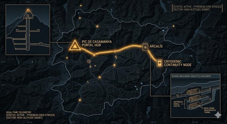
Andorra Underground “High above the clouds, the Pyrenees are hollow. Andorra isn’t just a tax haven; it’s...
Read More Read more about Andorra Underground
American Samoa Underground Digital noir geospatial map of American Samoa showing the subterranean SIGINT link between Mount Alava and the Pago Pago Harbor USO aperture, with amber data conduits and cross-section callouts.
  • American Samoa Underground

American Samoa Underground

bretwalters6969
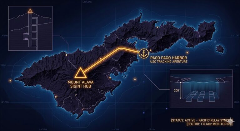
 American Samoa Underground “In the heart of the South Pacific, the mountains of Tutuila aren’t just volcanic—they’re...
Read More Read more about American Samoa Underground
Algeria Underground High-resolution geospatial map of Algeria rendered in a digital noir palette of deep blues, purples, and glowing neon-amber data points. The map shows the thick, amber maglev transport conduit line (AMCC-26) running northward beneath the Saharan crust, following natural geological shielding. This conduit explicitly connects the 'Sefar Ancient Interface (SAI-26)' (with a detailed cross-section of prehistoric mega-tunnels) to the 'Constantine COG Command (CCC-26)' (with an inset cross-section diagram of the 'Silent City' signal processing vaults), illustrating the active 2026 subterranean Continuity of Operations grid.
  • Algeria Underground

Algeria Underground

bretwalters6969
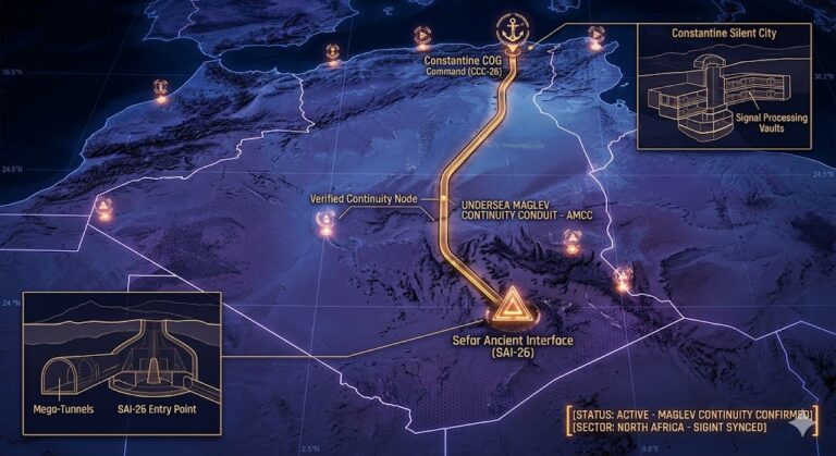
 Algeria Underground “Beneath the ‘Great Martian Gods’ of Tassili n’Ajjer, the Sahara is breathing. Algeria isn’t just...
Read More Read more about Algeria Underground
Albania Underground High-resolution digital noir map of Albania, visualizing the 2026 Continuity of Operations grid with a thick amber maglev transport conduit connecting the Gjadër Mountain Aperture (GMA-26) to the Sazan Island Naval Terminal (SNT-26), illustrating the deep-strata link and retrofitted mushroom bunker grid.
  • Albania Underground

Albania Underground

bretwalters6969
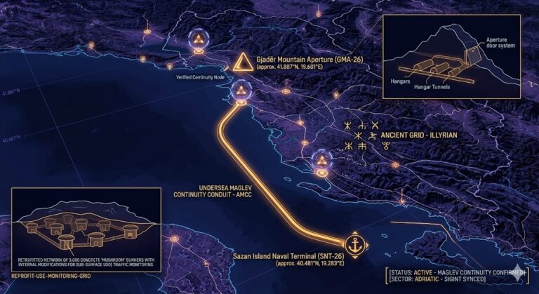
Albania Underground “In a land where the earth has 173,000 concrete eyes, the true secrets are buried...
Read More Read more about Albania Underground
The Polar Underground Master List Tactical blueprint of the Polar Underground (2026), showing the Axis Conduit Alpha/Omega connecting the Arctic (Greenland/Svalbard) to the Antarctic (Lake Vostok/Wilkes Land) Alien Bases and SSP hubs.
  • The Poles Underground

The Polar Underground Master List

bretwalters6969
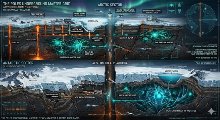
Polar Underground: 2026 Master Index “Arctic and Antarctic sub-grids act as the Earth’s ‘Thermal Heat Sinks’ and...
Read More Read more about The Polar Underground Master List

Posts pagination

Previous 1 2 3 4 5 6 … 55 Next

You may have missed

Digital noir geospatial map of the Republic of the Congo showing the subterranean link between the Pointe-Noire data vaults and Brazzaville command node, with neon-magenta conduits.
  • Congo Underground

Congo Underground

bretwalters6969
Digital noir geospatial map of Comoros showing glowing neon-blue conduits connecting the Itsoundzou Command Node to the Hahaya Lava Vaults. Inset reveals a cross-section of a Tier-III data vault buried in volcanic rock.
  • Comoros Underground

Comoros Underground

bretwalters6969
Digital noir geospatial map of Chad showing the subterranean link between the Adji Kosseï command node and the Doba pipeline, with neon-cyan data conduits.
  • Chad Underground

Chad Underground

bretwalters6969
A dark geospatial map rendering of the Central African Republic in a digital noir aesthetic. Glowing neon-red conduits visualize the 2026 subterranean grid, linking the 'Berengo Command Node' (GMA-26) to the 'Ndassima Mining Hub' (GHA-26). Intelligence forensics indicate 'Camp de Roux' (GRA-26) is synchronized. Telemetry confirms real-time SIGINT synchronization across the Grey Zone sector.
  • Central African Republic Underground

Central African Republic Underground

bretwalters6969
  • Home
  • Tunnels & Caves
  • Alien’s & UFO’s
  • Hollow Earth
  • Under the Ground
  • Underground Bases: The List
Copyright © All rights reserved. | MoreNews by AF themes.