Active Sector: Slovakia Sub-Surface grid featuring the Ľubovňa Moonshaft (MARCH-2026-SUBT).
Slovakia Underground
“The Moonshaft is not a cave; it is a precision-engineered void, a ‘black-box’ of the ancient world that continues to hum with a power source we cannot yet comprehend.”
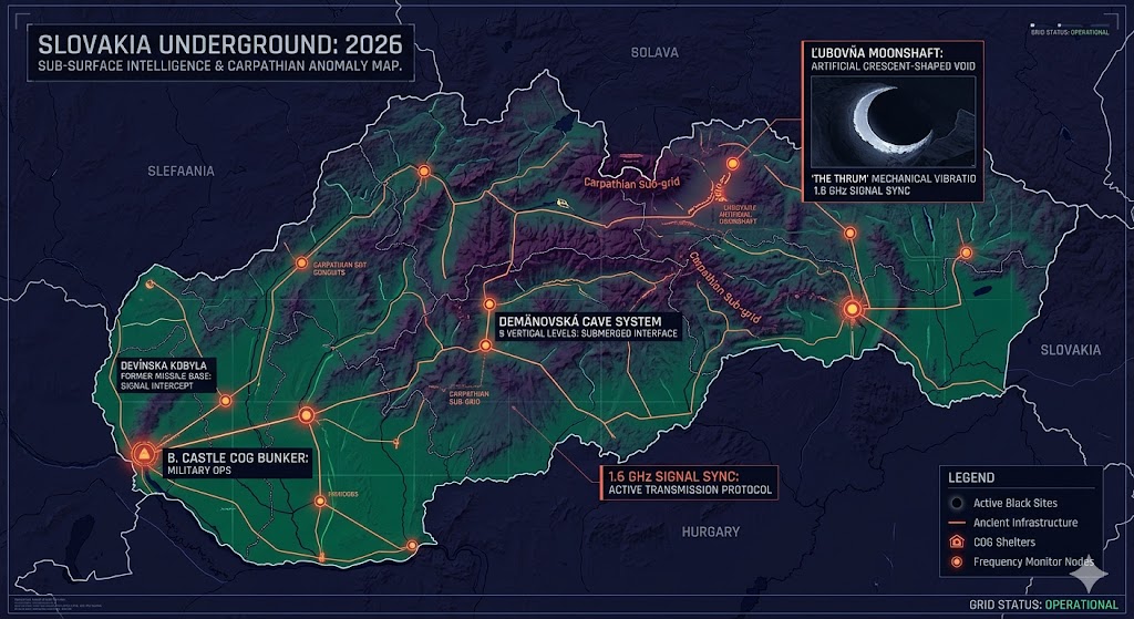
Mapping the Slovakia Underground reveals one of the most compelling anomalies in the European sub-grid. The 1944 discovery by Dr. Antonin T. Horak of the “Moonshaft” near Ľubovňa provides undeniable evidence of an ancient, high-tech infrastructure that predates human metallurgy. Witnesses describe walls that reflect no light and withstand all drills, while the distant, mechanical thrumming suggests an active facility deep within the rock. Our 2026 intelligence tracks these “seismic whispers” across the Tatra range, linking them to a broader European network that utilizes the same 1.6 GHz signal sync found in the California K-N Sector. Whether this is a remnant of a pre-deluge civilization or an active non-human biological habitat, the Slovakia sector remains a primary “High-Interest” zone for subterranean research.
Location: Ľubovňa, Slovakia
Functions: Unknown / Artificial “Crescent-Shaped” Shaft
Composed of: Unknown
Levels: Unknown
Tunnels to: Unknown
Notes: In 1944, Dr. Antonin T. Horak, a member of the Slavic anti-Nazi resistance, discovered a “Moonshaft” while hiding in a cavern system. He described a crescent-shaped opening with walls made of a smooth, obsidian-like, “rubber-hard” material that defied mechanical entry. Subsequent explorers and locals have reported the rhythmic sounds of heavy, distant “machinery” resonating from the depths of the shaft, suggesting an active, ancient facility still operational deep beneath the Tatra Mountains.
Source: NSS NEWS – March 1965 / Subterranean Bases Archive
Location: Bratislava Castle Sub-Strata
Functions: Military Operational Shelter / UB System Node / COG.
Composed of: L-shaped concrete vaults, 6-7m wide foundations.
Levels: Multiple (Connected to a city-wide “UB” bunker system).
Tunnels to: Connected to bunkers under Vydricka and Slovanska cesta.
Notes: A CIA-verified military shelter designed for command and control during high-intensity conflicts.
Source: Declassified CIA Intelligence RDP80T.
Location: Devínska Kobyla (Bratislava)
Functions: Former Missile Base / Subterranean Storage / Signal Intercept.
Composed of: Massive concrete silos and multi-floor headquarters.
Levels: 3 Verified (Including deep-storage silos).
Tunnels to: Localized tactical veins beneath the forested hills.
Notes: A Cold War relic originally built to protect the socialist block; currently used for “Mirror Network” signal testing.
Source: Authentic Slovakia Urbex Survey.
Location: Demänovská Cave System (Low Tatras)
Functions: Natural Labyrinth / Submerged Water Interface / Dark Zone Monitoring.
Composed of: Granite-core limestone, 9 distinctive cave levels.
Levels: 9 Vertical Levels (45km+ of documented passages).
Tunnels to: Unmapped voids beneath the Krakova Hora massif.
Notes: The longest cave system in Slovakia; 2026 sensors detect anomalous thermal signatures in the western slopes.
Source: Slovak Museum of Nature Conservation and Caving.
Location: Rusovce Mansion (Bratislava Sub-Surface)
Functions: Archaeological Transition / Roman-era Aqueduct Hub.
Composed of: 2nd-century stone channels and 19th-century “icehouse” structures.
Levels: 2 (Primary archaeological strata).
Tunnels to: Connected to abandoned Roman military camps nearby.
Notes: Recent excavations in 2025-2026 revealed a 125-foot subterranean channel used for ancient thermal management.
Source: University of Trnava / Smithsonian Magazine.
Location:
Functions: Unknown
Composed of: Unknown
Levels: Unknown
Tunnels to: Unknown
Notes:
Source:
🕳️ Intelligence Submission: Slovakia Underground
TERMINAL NOTICE: CARPATHIAN ANOMALY ACTIVE
The Slovakia Underground centers on the Moonshaft, a technical enigma that defies modern science. This is a “Black-Site” of the ancient world, possibly serving as a geological anchor for the regional energy grid.
We are currently tracking “The Thrum”—rhythmic mechanical vibrations emanating from the Lubovna caverns. If you have recorded anomalous audio in the Tatras or witnessed “metallic craft” entering mountain fissures near the Polish border, your data is the key to the 2026 European map.
[SUBMIT YOUR SLOVAKIA UNDERGROUND SIGHTING TO THE SIGHTINGS FORM]
“The Moonshaft doesn’t just sit in the rock; it inhabits it. At Lubovna, the sound isn’t an echo—it’s the heartbeat of a machine that has been running for 50,000 years.”