Skip to content
Subterranean Bases

Subterranean Bases

What's under your feet!

Primary Menu
  • Home
  • Underground Bases: The Complete List
  • The Branton Papers
    • Index of Cave and Tunnel Entrances of the America’s
    • Project Redbook
    • The Project Superman: Andy Pero Story
    • The Dulce Papers
    • The Omega Files
  • Under the Ground
  • Hollow Earth
Light/Dark Button
  • Home
  • 2026 Revision

2026 Revision

The Secrets of the Mojave: Part 2 A technical briefing board titled "The Secrets of the Mojave Page 2." It features the 1961 Phoenix crash-recovery of a liquid metal craft, the interrogation of a Tau Cetian named 'Hank' by Frank Drake and 'Oscar,' and a Grey Empire infiltration diagram. Includes star maps of Eridanus and Tau Ceti.
  • The Secrets of the Mojave

The Secrets of the Mojave: Part 2

bretwalters6969
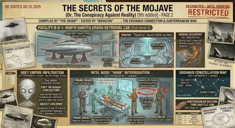
Is humanity merely a pawn in an interstellar game of chess? The Secrets of the Mojave (9th...
Read More Read more about The Secrets of the Mojave: Part 2
The Secrets of the Mojave —The Introduction A technical schematic of the 8-leveled Montauk Project underground facility (Facility M-1). The diagram details psychological ops, the Montauk Chair, wormhole gateways, Nazi Thule Society levels, and the vacuum-tube shuttle link to Dulce and the Mojave.
  • The Secrets of the Mojave

The Secrets of the Mojave —The Introduction

bretwalters6969
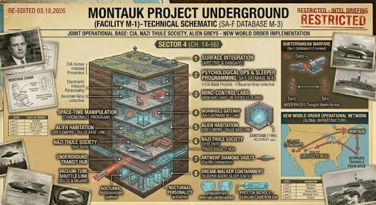
Are you prepared to look beneath the shifting sands of the high desert? Secrets of the Mojave...
Read More Read more about The Secrets of the Mojave —The Introduction

You may have missed

Digital noir geospatial map of the Republic of the Congo showing the subterranean link between the Pointe-Noire data vaults and Brazzaville command node, with neon-magenta conduits.
  • Congo Underground

Congo Underground

bretwalters6969
Digital noir geospatial map of Comoros showing glowing neon-blue conduits connecting the Itsoundzou Command Node to the Hahaya Lava Vaults. Inset reveals a cross-section of a Tier-III data vault buried in volcanic rock.
  • Comoros Underground

Comoros Underground

bretwalters6969
Digital noir geospatial map of Chad showing the subterranean link between the Adji Kosseï command node and the Doba pipeline, with neon-cyan data conduits.
  • Chad Underground

Chad Underground

bretwalters6969
A dark geospatial map rendering of the Central African Republic in a digital noir aesthetic. Glowing neon-red conduits visualize the 2026 subterranean grid, linking the 'Berengo Command Node' (GMA-26) to the 'Ndassima Mining Hub' (GHA-26). Intelligence forensics indicate 'Camp de Roux' (GRA-26) is synchronized. Telemetry confirms real-time SIGINT synchronization across the Grey Zone sector.
  • Central African Republic Underground

Central African Republic Underground

bretwalters6969
  • Home
  • Tunnels & Caves
  • Alien’s & UFO’s
  • Hollow Earth
  • Under the Ground
  • Underground Bases: The List
Copyright © All rights reserved. | MoreNews by AF themes.