Skip to content
Subterranean Bases

Subterranean Bases

What's under your feet!

Primary Menu
  • Home
  • Underground Bases: The Complete List
  • The Branton Papers
    • Index of Cave and Tunnel Entrances of the America’s
    • Project Redbook
    • The Project Superman: Andy Pero Story
    • The Dulce Papers
    • The Omega Files
  • Under the Ground
  • Hollow Earth
Light/Dark Button
  • Home
  • Mag-Lev Tunnels

Mag-Lev Tunnels

Cave and Tunnel Entrances of the America’s 1- 10 A vintage 1960s/70s style pulp collage illustration showing multiple panels focused on South American subterranean mysteries. It includes a map with GPS pins, a cross-section of an Andean cavern with a hidden city, and illustrations of indigenous guides, ancient scripts, and 9-foot 'Cave Martians'. The overall aesthetic is distressed and aged, resembling a Cold War intelligence manual.
  • Cave and Tunnel Entrances of the America’s

Cave and Tunnel Entrances of the America’s 1- 10

bretwalters6969
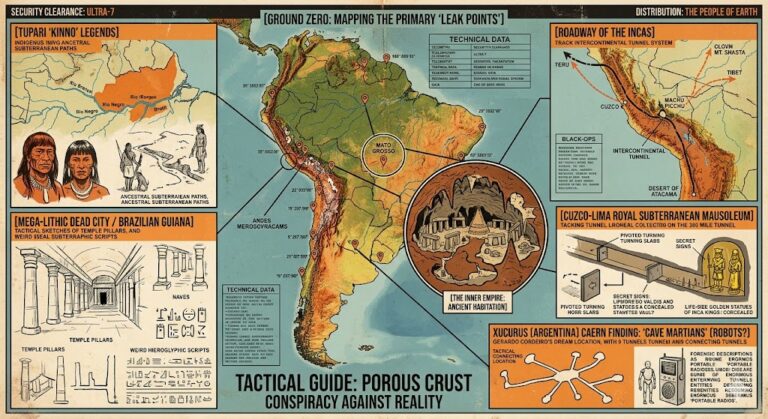
The Cave and Tunnel Entrances (1–10) serves as the “Ground Zero” for subterranean research, mapping the most...
Read More Read more about Cave and Tunnel Entrances of the America’s 1- 10
The Dulce Papers – Chapter 11: A DULCE BASE SECURITY OFFICER SPEAKS OUT Tactical schematic of the Armorlux Flash Gun with technical callouts and a background wireframe of the Dulce mag-lev shuttle system.
  • The Dulce Papers

The Dulce Papers – Chapter 11: A DULCE BASE SECURITY OFFICER SPEAKS OUT

bretwalters6969
Chapter 11, “A Dulce Base Security Officer Speaks Out,” is perhaps the most famous segment of the...
Read More Read more about The Dulce Papers – Chapter 11: A DULCE BASE SECURITY OFFICER SPEAKS OUT

You may have missed

Digital noir geospatial map of the Republic of the Congo showing the subterranean link between the Pointe-Noire data vaults and Brazzaville command node, with neon-magenta conduits.
  • Congo Underground

Congo Underground

bretwalters6969
Digital noir geospatial map of Comoros showing glowing neon-blue conduits connecting the Itsoundzou Command Node to the Hahaya Lava Vaults. Inset reveals a cross-section of a Tier-III data vault buried in volcanic rock.
  • Comoros Underground

Comoros Underground

bretwalters6969
Digital noir geospatial map of Chad showing the subterranean link between the Adji Kosseï command node and the Doba pipeline, with neon-cyan data conduits.
  • Chad Underground

Chad Underground

bretwalters6969
A dark geospatial map rendering of the Central African Republic in a digital noir aesthetic. Glowing neon-red conduits visualize the 2026 subterranean grid, linking the 'Berengo Command Node' (GMA-26) to the 'Ndassima Mining Hub' (GHA-26). Intelligence forensics indicate 'Camp de Roux' (GRA-26) is synchronized. Telemetry confirms real-time SIGINT synchronization across the Grey Zone sector.
  • Central African Republic Underground

Central African Republic Underground

bretwalters6969
  • Home
  • Tunnels & Caves
  • Alien’s & UFO’s
  • Hollow Earth
  • Under the Ground
  • Underground Bases: The List
Copyright © All rights reserved. | MoreNews by AF themes.