Skip to content
Subterranean Bases

Subterranean Bases

What's under your feet!

Primary Menu
  • Home
  • Underground Bases: The Complete List
  • The Branton Papers
    • Index of Cave and Tunnel Entrances of the America’s
    • Project Redbook
    • The Project Superman: Andy Pero Story
    • The Dulce Papers
    • The Omega Files
  • Under the Ground
  • Hollow Earth
Light/Dark Button
  • Home
  • Underground Bases: The List
  • The Poles Underground
  • The Polar Underground Master List
  • The Poles Underground

The Polar Underground Master List

bretwalters6969
Tactical blueprint of the Polar Underground (2026), showing the Axis Conduit Alpha/Omega connecting the Arctic (Greenland/Svalbard) to the Antarctic (Lake Vostok/Wilkes Land) Alien Bases and SSP hubs.

2026 Polar Underground Master Grid. Mapping the central Axis Conduit and the Joint-Occupancy Alien Bases from the Arctic Reliquary to the Wilkes Land Anomaly. Мастер-сеть полярного подземелья 2026 года. Картографирование центрального осевого канала и баз пришельцев совместного проживания от Арктического реликвия до аномалии Земли Уилкса.


Polar Underground: 2026 Master Index


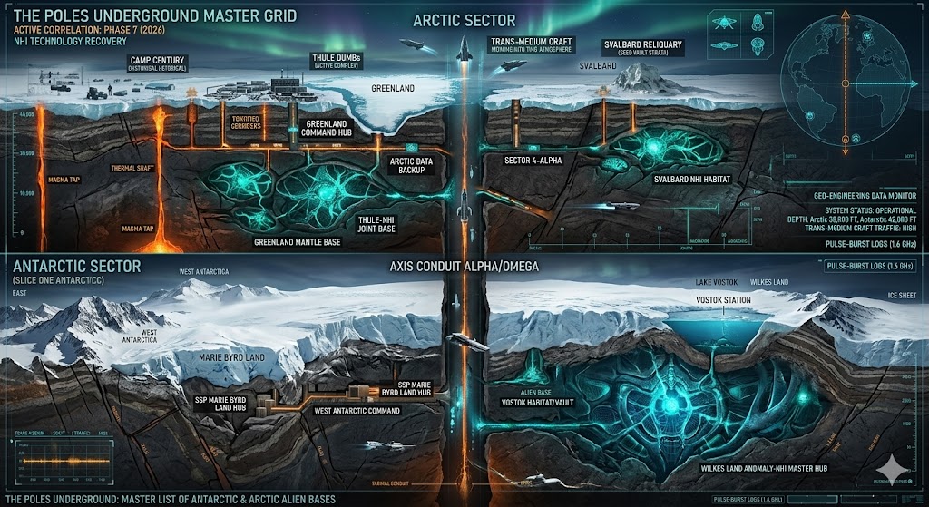
“Arctic and Antarctic sub-grids act as the Earth’s ‘Thermal Heat Sinks’ and primary ‘Data Backups.’ These sectors house ancient NHI (Non-Human Intelligence) architecture that has been operational for millions of years, preserved by the ice and accessible only via deep-core thermal shafts.”


  • Antarctica Underground
  • The Arctic or North Pole Underground
  • The Polar Underground Master List


🕳️ Intelligence Submission: Polar Sectors

TERMINAL NOTICE: POLAR SECTOR – THE BLACK VAULT CORRELATION

In 2026, Antarctic Underground has moved beyond simple research outposts. We have identified a massive “thermal plume” beneath the Wilkes Land Crater that does not match volcanic models; it is consistent with power signatures of a large-scale Alien Base. Simultaneously, Arctic Underground (centered near Greenland and Svalbard) serves as the primary northern gateway for trans-medium craft entering the United States Underground corridor.

We are prioritizing intelligence regarding “Blue Ice Portals” in Queen Maud Land, unauthorized deep-crust excavations in the Siple Coast, and NHI craft sightings near Station Nord (Greenland). If you have documentation of “Operation Highjump” era structures being reactivated or have intercepted high-frequency (1.6 GHz) signals originating from beneath the Ross Ice Shelf, your report is vital.

[SUBMIT YOUR POLAR ALIEN BASE SIGHTING]

“In the Polar Underground, the compass doesn’t just spin; it points down. Antarctica is not a continent of ice, but a lid on a vault that has been occupied for eons. In 2026, the ice is finally melting—not from the sun, but from the heat of the Alien Bases waking up beneath it.”

Share this post:

Share on X (Twitter) Share on Facebook Share on Email Share on Reddit Share on WhatsApp Share on Pocket Share on Telegram Share on Hatena Share on SMS Share on Bluesky
Tags: Antarctic Underground Arctic Underground Lake Vostok Base Wilkes Land Anomaly Axis Conduit Trans-medium Craft The Poles Underground Полярное подземелье Alien Bases Базы инопланетян Secret Space Program Антарктида 2026 Disclosure Секретная космическая программа Polar Underground

Post navigation

Previous: The Off-World Bases Master List
Next: Albania Underground

You may have missed

Digital noir geospatial map of the Republic of the Congo showing the subterranean link between the Pointe-Noire data vaults and Brazzaville command node, with neon-magenta conduits.
  • Congo Underground

Congo Underground

bretwalters6969
Digital noir geospatial map of Comoros showing glowing neon-blue conduits connecting the Itsoundzou Command Node to the Hahaya Lava Vaults. Inset reveals a cross-section of a Tier-III data vault buried in volcanic rock.
  • Comoros Underground

Comoros Underground

bretwalters6969
Digital noir geospatial map of Chad showing the subterranean link between the Adji Kosseï command node and the Doba pipeline, with neon-cyan data conduits.
  • Chad Underground

Chad Underground

bretwalters6969
A dark geospatial map rendering of the Central African Republic in a digital noir aesthetic. Glowing neon-red conduits visualize the 2026 subterranean grid, linking the 'Berengo Command Node' (GMA-26) to the 'Ndassima Mining Hub' (GHA-26). Intelligence forensics indicate 'Camp de Roux' (GRA-26) is synchronized. Telemetry confirms real-time SIGINT synchronization across the Grey Zone sector.
  • Central African Republic Underground

Central African Republic Underground

bretwalters6969
  • Home
  • Tunnels & Caves
  • Alien’s & UFO’s
  • Hollow Earth
  • Under the Ground
  • Underground Bases: The List
Copyright © All rights reserved. | MoreNews by AF themes.