Skip to content
Subterranean Bases

Subterranean Bases

What's under your feet!

Primary Menu
  • Home
  • Underground Bases: The Complete List
  • The Branton Papers
    • Index of Cave and Tunnel Entrances of the America’s
    • Project Redbook
    • The Project Superman: Andy Pero Story
    • The Dulce Papers
    • The Omega Files
  • Under the Ground
  • Hollow Earth
Light/Dark Button
South Carolina Underground
  • South Carolina Underground

South Carolina Underground

bretwalters6969
South Carolina Underground   Location: Columbia South Carolina Functions: Unknown Composed of: Unknown Levels: Unknown   Tunnels to: Unknown Notes:...
Read More Read more about South Carolina Underground
Virginia Underground Digital noir geospatial map of Virginia showing the subterranean Federal Arc connecting Mount Weather, the Pentagon, and CIA Langley with neon-blue data conduits.
  • Virginia Underground

Virginia Underground

bretwalters6969
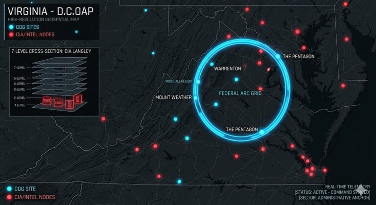
Virginia Underground “Beneath the ‘Federal Arc’ of Mount Weather and the sub-waterline vaults of Camp Peary, the...
Read More Read more about Virginia Underground
The Washington D. C. Underground Digital noir geospatial map of Washington D.C. showing the 17-level NOD installation under the White House and glazed tunnels connecting to the House of the Temple.
  • Washington D.C. Underground

The Washington D. C. Underground

bretwalters6969
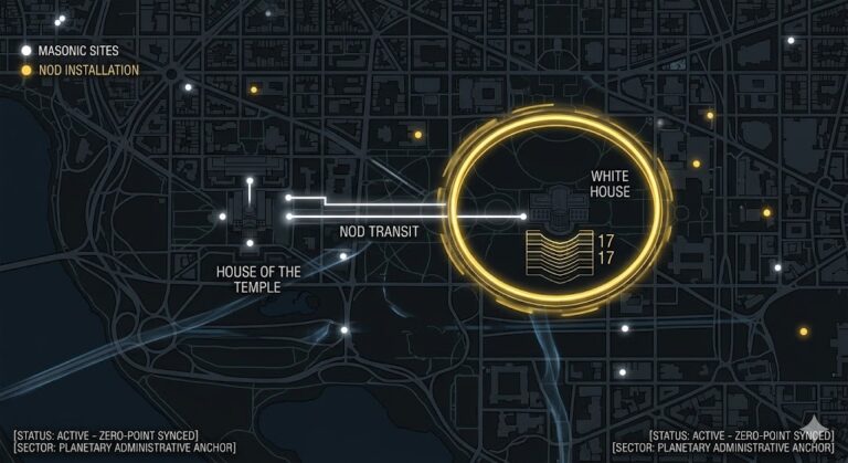
Washington D.C. Underground “Beneath the Masonic pentagram of the District and the 17-level ‘NOD’ vaults of the...
Read More Read more about The Washington D. C. Underground
West Virginia Underground Digital noir geospatial map of West Virginia showing the subterranean Greenbrier bunker, Sugar Grove SIGINT station, and the Mothman anomaly zone.
  • West Virginia Underground

West Virginia Underground

bretwalters6969
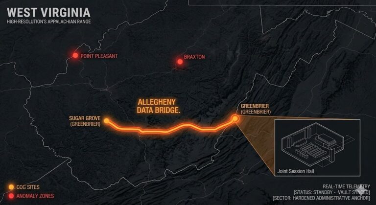
West Virginia Underground “Beneath the five-star luxury of the Greenbrier and the ‘Terror Circles’ of Point Pleasant,...
Read More Read more about West Virginia Underground
Wyoming Underground Digital noir geospatial map of Wyoming showing the Gas Hills alien marker, Sheridan mountain tunnels, and the transit conduits to Denver and Salt Lake City.
  • Wyoming Underground

Wyoming Underground

bretwalters6969
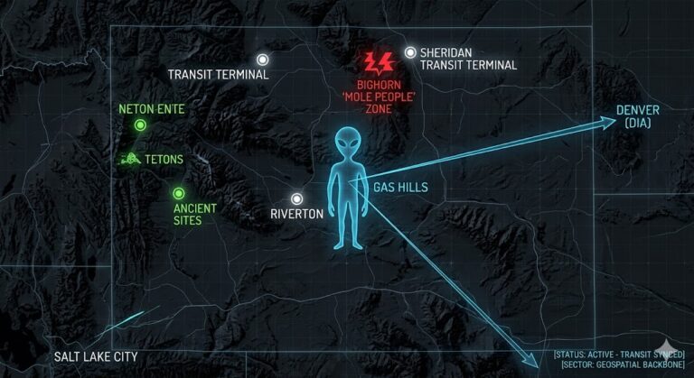
Wyoming Underground “Beneath the ‘Great Doors’ of the Bighorns and the satellite-visible ‘Alien Markers’ of the Gas...
Read More Read more about Wyoming Underground
Washington Underground Digital noir geospatial map of Washington showing subterranean hybrid study centers, Mt. Rainier UFO vaults, and the Madigan Grey Nest nodes.
  • Washington Underground

Washington Underground

bretwalters6969
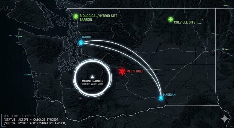
Washington Underground “Beneath the ‘Bottomless’ mystery of Manastash Ridge and the hybrid ‘Study Centers’ of Barron, the...
Read More Read more about Washington Underground
Vermont Underground Digital noir geospatial map of Vermont showing neon-green data conduits connecting the East Mountain Radar Base to the Northeast Kingdom stone chambers.
  • Vermount Underground

Vermont Underground

bretwalters6969
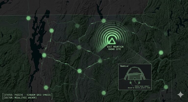
Vermont Underground “Beneath the decaying towers of East Mountain and the ancient beehive chambers of the Green...
Read More Read more about Vermont Underground
Maine Underground
  • Maine Underground

Maine Underground

bretwalters6969
Maine Underground “The granite of the North doesn’t just hold the weight of the pines; it anchors...
Read More Read more about Maine Underground
Mississippi Underground
  • Mississippi Underground

Mississippi Underground

bretwalters6969
Mississippi Underground   Location: Naval Air Station Meridian Mississippi Functions: Unknown Composed of: Unknown Levels: Unknown   Tunnels to: Unknown Notes:...
Read More Read more about Mississippi Underground
New Hampshire Underground
  • New Hampshire Underground

New Hampshire Underground

bretwalters6969
New Hampshire Underground   Location: UnKnown New Hampshire Functions: Unknown Composed of: Unknown Levels: Unknown   Tunnels to: Unknown Notes:...
Read More Read more about New Hampshire Underground

Posts pagination

Previous 1 … 44 45 46 47 48 49 50 … 55 Next

You may have missed

Digital noir geospatial map of the Republic of the Congo showing the subterranean link between the Pointe-Noire data vaults and Brazzaville command node, with neon-magenta conduits.
  • Congo Underground

Congo Underground

bretwalters6969
Digital noir geospatial map of Comoros showing glowing neon-blue conduits connecting the Itsoundzou Command Node to the Hahaya Lava Vaults. Inset reveals a cross-section of a Tier-III data vault buried in volcanic rock.
  • Comoros Underground

Comoros Underground

bretwalters6969
Digital noir geospatial map of Chad showing the subterranean link between the Adji Kosseï command node and the Doba pipeline, with neon-cyan data conduits.
  • Chad Underground

Chad Underground

bretwalters6969
A dark geospatial map rendering of the Central African Republic in a digital noir aesthetic. Glowing neon-red conduits visualize the 2026 subterranean grid, linking the 'Berengo Command Node' (GMA-26) to the 'Ndassima Mining Hub' (GHA-26). Intelligence forensics indicate 'Camp de Roux' (GRA-26) is synchronized. Telemetry confirms real-time SIGINT synchronization across the Grey Zone sector.
  • Central African Republic Underground

Central African Republic Underground

bretwalters6969
  • Home
  • Tunnels & Caves
  • Alien’s & UFO’s
  • Hollow Earth
  • Under the Ground
  • Underground Bases: The List
Copyright © All rights reserved. | MoreNews by AF themes.