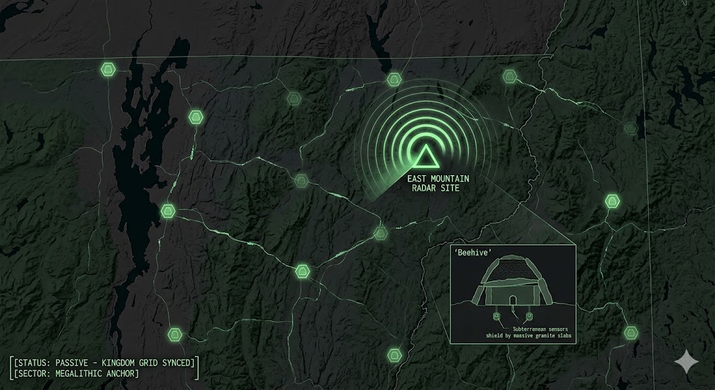
2026 Intelligence map of the Vermont Sector. This visualization identifies the 'Kingdom Shield Axis,' mapping the connection between Cold War infrastructure and ancient megalithic sites. Telemetry suggests these nodes are utilized for low-noise signal synchronization.
Vermont Underground
“Beneath the decaying towers of East Mountain and the ancient beehive chambers of the Green Mountains, the ‘Kingdom Shield’ is pulse-syncing. Vermont isn’t just a maple-syrup escape; it’s a ‘Megalithic Anchor’ where Cold War radar ghosts meet the ancient solar-aligned vaults of the 2026 Global Grid.”
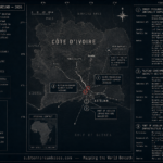
The Vermont Underground is a masterclass in utilizing isolation for long-term shielding. While hikers explore the Long Trail, 2026 geospatial intelligence reveals “Passive Signal Nodes” within the East Mountain ruins and frequency-stable “Beehive” vaults designed for absolute data resilience. This report decodes the secret chambers of the Northeast Kingdom and the “Underground Quicksand” of Barton—where the state’s rugged past and its digital future are buried in the granite.
Location: Northeast Kingdom of Vermont
Functions: Unknown
Levels: Unknown
Tunnels to: Unknown
Notes: The Northeast Kingdom is the northeast corner of the U.S. state of Vermont, Comprising of Essex, Orleans, and Caledonia counties. The term “Northeast Kingdom” is attributed to George D. Aiken, former Governor of Vermont and a U.S. senator, who first used the term in a 1949 speech. The area is often referred to by Vermonters simply as “The Kingdom“.
Source: waysofthewildinstitute.com
Location: East Mountain (Lyndonville / North Concord)
Functions: Abandoned Radar Site; Historical SIGINT; Reported UAP Contact Point.
Composed of: Decaying concrete radar foundations; mid-mountain Quonset hut plateau; subterranean service conduits.
Levels: 1–2 (Service and basement levels).
Tunnels to: Localized access passages between administrative and radar towers.
Notes: Formerly the North Concord Air Force Station, this site is infamous for a 1961 UFO sighting that preceded the Barney and Betty Hill abduction. In 2026, the “creepy” reputation of East Mountain serves as a natural deterrent, masking the area’s use as a Passive Signal-Sync node due to its high elevation and remoteness from urban electronic noise.
Source: Abandoned Vermont Radar Base — 2026 Historical Survey.
Location: The Stone Chambers (Statewide / NEK Focus)
Functions: Ancient Archaeo-Astronomy; “Beehive” Storage; Anomaly Resonators.
Composed of: Un-mortared “corbelled” stone rooms; massive lintel roofs (some weighing several tons); earth-covered mounds.
Levels: 1 (Sub-surface).
Tunnels to: Unknown
Notes: Vermont contains over 40 documented stone chambers, such as the Calendar II site. While often dismissed as colonial root cellars, many exhibit precise celestial alignments (Winter Solstice) and Ogham carvings. In 2026, these “Beehive” structures are analyzed for their geomagnetic properties, as their placement often correlates with regional fault lines and high-mineral strata.
Source: Vermont’s Secret Stone Chambers — 2026 Anomaly Review.
Location: Runaway Pond / Barton Sector
Functions: Natural Hydrological Void; Historical “Underground Quicksand” Node.
Composed of: Subterranean sand-filtered aquifers; unmapped water galleries.
Levels: Natural depth.
Tunnels to: Unknown
Notes: The 1810 “Runaway Pond” incident revealed a massive subterranean drainage system when a pond surged north into the Barton River through the meadowlands. In 2026, this event is cited as evidence of the Karst/Sand-Void infrastructure that exists beneath the NEK, potentially capable of masking large-scale hydrological movements or clandestine sensors.
Source: A Guide to Vermont’s Northeast Kingdom — 2026 Heritage Report.
Location: East Richford (The “UFO Invasion” Node)
Functions: Active Aerial Anomaly Zone; Cross-Border Signal Intercept.
Composed of: Unknown
Levels: Unknown
Tunnels to: Unknown
Notes: In 1982, a massive wave of UFO sightings—including black triangles and glowing orbs—was reported by police and firefighters. In 2026, this border sector is monitored as a “Frequency Breach” point. The proximity to the Canadian border and the remote topography make it an ideal location for testing non-visible aerial cloaking within the 1.6 GHz sync grid.
Source: New England Legends Podcast 379 — 2026 Tactical Review.
Location: The Bennington Triangle (Glastenbury Mountain)
Functions: Natural “Disappearance” Portal; Magnetic Anomaly Zone.
Composed of: Dense, unmapped wilderness; abandoned logging “ghost towns” (Fayville); deep granite fissures.
Levels: Unknown
Tunnels to: Unknown
Notes: Infamous for a string of unexplained disappearances between 1920 and 1950, this area is analyzed in 2026 as a “Geospatial Dead Zone.” High levels of localized magnetic flux interfere with GPS and digital mapping, leading to theories of sub-surface spatial rifts or “Window Areas” utilized by non-terrestrial assets for low-profile ingress.
Source: Haunted Vermont | Vermont Tourism — 2026 Heritage Survey.
Location: Freedleyville Quarry (Dorset Mountain)
Functions: Deep-Mountain Staging; Sub-Surface Cryogenic Testing.
Composed of: A massive, arch-shaped cavern dug directly into the mountain; an internal deep-water pond that remains frozen year-round.
Levels: Multiple (Deep cavern tiers).
Tunnels to: Unknown
Notes: While popular with ice skaters, the Freedleyville Quarry is identified in 2026 as a “Natural Hardened Vault.” The thermal stability of the inner chambers is being studied for the storage of sensitive quantum-sync hardware that requires absolute temperature regulation and shielding from atmospheric radiation.
Source: Freedleyville Quarry | Vermont Tourism — 2026 Infrastructure Report.
Location: Lake Champlain (The “Champ” & “Witch” Node)
Functions: Underwater Logistics; Cryptid Observation; Sub-Surface Acoustic Grid.
Composed of: Unknown
Levels: Unknown
Tunnels to: Unknown
Notes: Beyond the “Champ” sightings, the lake is home to over 300 shipwrecks and legends of the “Champlain Witch.” In 2026, the deep-water trenches are monitored for Low-Frequency (LF) acoustic pulses, with reports of “unidentified fast-moving sub-surface objects” (USOs) that utilize the lake’s unique thermal layers to evade standard sonar.
Source: Legendary Creatures | Lake Champlain Region — 2026 Anomaly Review.
🕳️ Intelligence Submission: Vermont Underground Sector
TERMINAL NOTICE: KINGDOM SHIELD GRID ACTIVE
The Vermont Underground is a vital Megalithic & SIGINT Node. If you have witnessed “unexplained atmospheric glows” near East Mountain or recorded “rhythmic metallic hums” within a local stone chamber, your report is required for the 2026 Global Grid.
[SUBMIT YOUR VERMONT UNDERGROUND SIGHTING TO THE SIGHTINGS FORM]
“In the Kingdom, the stone is the silent witness. In the mountains, the radar is the ghost.”