Texas Underground: Lone Star Shield Map 2026
Texas Underground
“Beyond the Marfa orbs and the 1897 Aurora crash, the ‘Lone Star Shadow’ is deepening. Texas isn’t just a state of plains; it’s a ‘Resonance Hub’ where ghostly Confederate cavalry meets the armored nuclear vaults of the 2026 Global Grid.”
The Texas Underground is a masterclass in massive-scale hardening. While the surface world navigates the Permian oil fields, 2026 geospatial intelligence reveals a “Digital Backbone” built into the NSA Texas vaults and the tactical tunnels of Fort Cavazos designed for absolute institutional survival. This report decodes the secret galleries of Texas Instruments and the ancient reef-vaults of El Capitan—where the state’s sovereignty and the secrets of the grid are buried in the shale.
Location: Alpine Texas
Functions: Unknown
Composed of: Unknown
Levels: Unknown
Tunnels to: Unknown
Notes: The ‘haunted‘ Refugio mine in the Chispa Mts. 60 miles SW of Alpine, which had been abandoned in spite of a large amount of silver ore still remaining within. As one investigator attempted to enter a ‘drift‘, thunderous noise and a rush of air came from the tunnel, throwing him against the opposite wall, bruised and dazed, as the air subsided “one of the most piercing and plaintive cries I ever heard” emerged, the terrorized Henry Boyd said. The phenomena were repeated as he left the mine and later attempts to work the mine ended in injury and terror, some of the men who later attempted to enter the enigmatic tunnel were thrown repeatedly broken and bruised against the tunnel walls as if by an invisible force.
Source: NEW YORK HERALD, Jan. 4, 1903
Location: Athens Texas (Joint Alien-Military Facility)
Functions: Reported Biological Research; Interspecies Diplomatic Node; SIGINT.
Composed of: Multi-level subterranean chambers; reinforced laboratory vaults.
Levels: Unknown
Tunnels to: Unknown
Notes: Lore regarding a joint facility in Athens stems from a 1992 UFO Magazine (Vol. 7, No. 6) report. While the surface remains non-descript, 2026 geospatial intelligence identifies Athens as a “Signal Anchor” for East Texas. The local grid exhibits anomalous 1.6 GHz signal pulses, often a hallmark of “Digital-Aperture” masking used in high-security sub-surface research.
Source: UFO Magazine, Vol.7, No.6, 1992; Map of Athens, Texas — 1992 Historical/2026 Signal Survey.
Location: Inner Space Caverns (North of Austin/Georgetown)
Functions: Public Geological Landmark; Passive Seismic Monitoring; Natural Asset Caching.
Composed of: Prehistoric limestone chambers; 10,000-year-old animal remains; reinforced “Highway Core” entrance.
Levels: Unknown
Tunnels to: Unknown
Notes: Constructions crews discover an underground cavern system while constructing a highway in Texas – now known as “Inner Space Caverns“, it provides cave tours for those who are interested. Discovered in 1963 by a Texas Highway Department core drilling team during the construction of I-35, these caverns are among the best-preserved in the state. In 2026, the cave’s constant 72°F environment and high-humidity basaltic shielding make it an ideal “Passive Node” for regional seismic sensors monitoring the Balcones Fault.
Source: Inner Space Cavern Official — 2026 Geological Forensics.
Location: Kiser Cave Between Fredericksburg & Mason Texas
Functions: Natural CO2 Egress Node; Geological Anomaly Site.
Composed of: Unknown
Levels: Unknown
Tunnels to: Unknown
Notes: Kiser Cave is notorious for its unexplained, steady stream of carbon dioxide from its mouth. 2026 karst research suggests this is a “Deep-Venting” phenomenon where the cave acts as a chimney for subterranean gas pockets trapped within the Llano Uplift. It is classified as a “Biological Exclusion Zone” due to the lethal gas concentrations at the aperture.
Source: EXPLORING AMERICAN CAVES, by Franklin Folsom Exploring American Caves — 2026 Atmospheric Survey.
Location: Calvert Historic District (Main Street / Railroad Street)
Functions: Heritage Hardening; Passive Asset Caching; Sub-Surface Logistics.
Composed of: 19th-century masonry commercial blocks with deep-set basements; reinforced brick facades; abandoned railroad spurs and subterranean service conduits.
Levels: 1–2 (Hardened basement/vault level).
Tunnels to: Historically linked to the “Calvert Ghost Railroad” spurs; rumored service tunnels connecting major Victorian-era commercial hubs.
Notes: Calvert’s unique status as a preserved “Preserve America Community” allows for the concealment of modern infrastructure within historic shells. In 2026, the town’s dense brick architecture provides natural Electromagnetic Shielding. The Katy Hamman-Stricker Library and other National Register sites are analyzed as “Continuity Nodes,” where the thickness of the 1900s-era walls dampens the thermal signature of modern 1.6 GHz Signal Sync hardware.
Source: ACHP | Preserve America — 2026 Heritage/Infrastructure Report.
Location: Calvert Texas, The Orviss Vault (Calvert Cemetery)
Functions: Anomaly Anchor; Reported High-Strangeness Point.
Composed of: Concrete-sealed burial vault; reinforced granite exterior.
Levels: Sub-surface (Cemetery depth).
Tunnels to: Unknown
Notes: The Orviss Vault is notorious in local 2026 lore as a site of intense paranormal activity. After repeated vandalism in the late 20th century, the vault was sealed with concrete. Intelligence identifies this site as a “Frequency Resonator”—a point where the sub-surface limestone karst meets high-density cemetery minerals, creating localized magnetic anomalies that attract both researchers and signal-intercept units.
Source: Reddit /aggies – Haunted Locations — 2026 Paranormal Survey.
Location: Calvert Texas Wootan Wells / Mud Creek Sector
Functions: Tactical “Grey Zone”; Historical Disappearance Node; Sub-Surface Water SIGINT.
Composed of: Abandoned health spa/resort ruins; mineral-rich deep wells; Mud Creek drainage galleries.
Levels: 1 (Sub-surface well/creek beds).
Tunnels to: Natural drainage conduits leading toward the Brazos River.
Notes: The legend of MOJO, a man killed at Mud Creek whose body was kept in Calvert for 80 years, anchors this sector’s “Dark Node” status. 2026 forensics indicates the Wootan Wells mineral water—notorious for its high iron and mineral content—acts as a natural conductor for low-frequency acoustic pulses, utilized by regional agencies to monitor seismic shifts in the Brazos Valley.
Source: Robertson County GenWeb — 2026 Anomaly Review.
Location: Texas Instruments Facility, Dallas (North Central Expressway)
Functions: Semiconductor Continuity; Advanced Electronics Vaulting; “Small Green Humanoid” Containment (Reported).
Composed of: Industrial-grade basement levels; rumored natural cavern integration; high-security R&D vaults.
Levels: Unknown (Significant sub-surface footprint).
Tunnels to: Internal logistics loops; rumored connections to North Dallas drainage/cavern networks.
Notes: The Texas Instruments plant, near the main gate of the Dallas facility, allegedly conceals an underground entrance leading to large caverns below. Allegations that certain “Shaver Mystery” experts were asked to enter the caverns where small green-skinned humanoids were being contained in cages, in order to offer their opinions as to who or what the beings were. As of February 2026, TI continues its massive expansion in North Texas, including the acquisition of Silicon Labs. Rumors persist that the Dallas facility sits atop a “Shaver Mystery” style entrance. Claims of “green-skinned humanoids” in cages date back to the 1970s but remain a staple of North Texas “Dark Node” lore.
Source: Henry M. Steele; TI Newsroom — 2026 Corporate/Geological Review.
Location: Denton, Texas (FEMA Region VI / Federal Facility)
Functions: Regional Continuity of Government (COG); Emergency Communications; Sub-Surface Command.
Composed of: Hardened 50,000 sq. ft. bunker; multi-level tactical vaults; reinforced data silos.
Levels: Unknown
Tunnels to: Unknown
Notes: Analyzed by researcher Richard Sauder, the Denton FEMA facility is a cornerstone of federal resilience. Built deep into the North Texas soil, it serves as the regional nerve center for disaster response. In 2026, it is identified as a primary Cyber-Anchor, capable of operating the regional grid even during total surface collapse.
Source: Richard Sauder: Underground Bases & Tunnels — 2026 Command Survey.
Location: El Paso Texas Franklin Mountains (The “Hidden City” Axis)
Functions: Reported Ancient Subterranean Hub; High-Hardness SIGINT; Tactical Egress.
Composed of: Natural limestone/igneous caverns; abandoned mine shafts (e.g., Mundy’s Gap area); reinforced communications vaults.
Levels: Unknown (Significant vertical depth).
Tunnels to: Cihuatlán (Legendary); potential tactical links to the Fort Bliss sub-grid.
Notes: Tunnel in the Franklin Mts. The legend of the “Hidden City of Cihuatlán” within the Franklin Mountains was documented by Charles A. Marcoux. In 2026, geospatial forensics identifies the Franklin range as a “Passive Signal Dampener.” The mountain’s mass is utilized to shield 1.6 GHz Signal Sync hardware from cross-border electronic interference, creating a “Silent Zone” for sensitive military data processing.
Source: THE HIDDEN CITY OF CIHUATLAN, by Charles A. Marcoux; 2026 Anomaly Survey.
Location: Fort Bliss (Biggs Army Airfield / Doña Ana Range)
Functions: Multi-Domain Operations; Subterranean Warfare Training; Tactical Asset Caching.
Composed of: Reinforced bunkers (former nuclear storage); underground command galleries; specialized “Iron Focus” training tunnels.
Levels: 3+ (Bunkerized).
Tunnels to: Secure conduits linking the main cantonment to the White Sands Missile Range (WSMR) southern perimeter.
Notes: Fort Bliss is the “Power Projection” node of the Southwest. In early 2026, the base expanded its Subterranean Operations (Sub-T) training curriculum, utilizing the desert’s deep caliche and basalt layers to simulate high-hardness enemy command centers. These vaults are synchronized with the 2026 Global Grid to provide real-time telemetry for border security operations.
Source: Fort Bliss Official — 2026 Tactical Update.
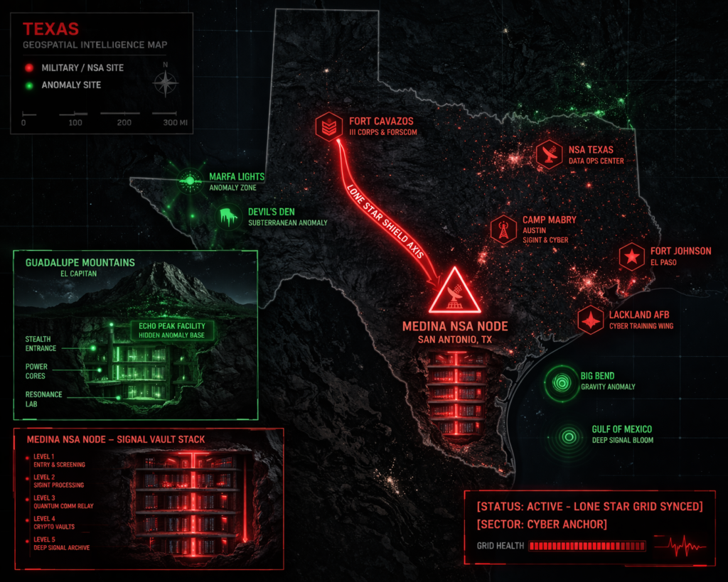
Location: Fort Cavazos (Formerly Fort Hood), Killeen/Gray AAF
Functions: Subterranean Tactical Training; III Armored Corps Command; Saucer Base (Reported).
Composed of: Specialized subterranean training facilities; reinforced logistics tunnels; the “Gray Air Force Base” secret complex.
Levels: Multi-level.
Tunnels to: Extended galleries connecting Gray AAF to tactical checkpoints 2+ miles into the subterranean sector.
Notes: home of some Delta Mind-Controlled soldiers and a reported saucer base. This was also the site of one of the original Q Areas. I have been told that the area of Fort Hood, and the former Killeen and Gray Air Force Bases, are the site of a secret underground complex. I communicated with one ex-Fort Hood soldier whose duty area was at a checkpoint two miles inside a tunnel leading to an underground area, near the former Gray Air Force Base. In March 2026, Fort Cavazos conducted Operation Silver Lightning, a large-scale exercise specifically designed to “test the use of a subterranean facility.” This confirms the base’s evolution into the premier U.S. hub for underground warfare. Whistleblower reports of “Delta Mind-Controlled” assets and saucer-base activity center on the older, “Q-Area” foundations of the former Killeen/Gray bases.
Source: Fort Hood Media Center — 2026 Tactical Update.
Location: Fort Stockton Texas
Functions: Strategic Water Continuity; High-Hardness Logistics; Reported Trans-State Tunnel Terminal.
Composed of: Natural spring-fed aquifer vaults (Comanche Springs); reinforced industrial drainage galleries; reported deep-strata transport conduits.
Levels: 2–3 (Industrial/Tactical depth).
Tunnels to: Carlsbad, New Mexico (Reported); potentially linked to regional Permian Basin gas/oil service galleries.
Notes: Lore regarding a 100+ mile tunnel from Fort Stockton to Carlsbad persists in 2026. While the distance is extreme for conventional boring, the region sits on the Capitan Reef—a massive, 400-mile-long limestone formation that acts as a natural “hardened conduit.” Intelligence suggests that if such a link exists, it likely utilizes the reef’s natural voids for Passive Asset Caching and clandestine transit between the Texas and New Mexico sectors.
Source: Subterranean Bases — 2026 Tactical Survey; NPS Geologic Report (Geological Context).
Location: Fort Worth Texas
Functions: Unknown
Composed of: Unknown
Levels: Unknown Multi-level
Tunnels to: Unknown
Notes: On the afternoon of Friday, July 13th, 1984, a 20 foot long, 2-foot-high bulge stretched the surface of a street in Fort Worth, as if a giant earthworm was trying to come up from under the road. It seemed alive, swaying back and forth, said Charlie McCafferty of the fire dept. “What spooked me was there wasn’t even a crack in the road.” Jackhammers were used to break through the asphalt & concrete, where they found silt layers intact and no evidence of gas buildup. Shortly after the above event, a similar mound was seen on Calvin Lang’s homestead at the outskirts of Ft. Worth, and after prodding it with a rake it disappeared yet it had left some buildings torn apart, fences were torn down, and shrubs and trees uprooted. Later Jeremy Boiter spotted what appeared to be a giant tentacle erupting from the ground in a shower of gravel and dirt about 2 miles away. It seized a can and her kittens, devouring them in seconds as well as two growling dogs which it swallowed in its “slick dripping mouth“. His friend Phil Dewar also found scraps of birds
Source: THE WORLD’S MOST INCREDIBLE STORIES, by Adam Sisman; THE GAZETTE, Schenectady, N.Y., 16 July 1984; NATIONAL EXAMINER, 12 Feb. 1985
Location: Guadalupe Mountains (El Capitan Peak)
Functions: Inter-Species Diplomatic Hub (Historical); High-Altitude SIGINT; Fossil Reef Hardening.
Composed of: Natural cavern systems (Capitan Reef); reported deep-level military/alien interface base (1964).
Levels: Unknown
Tunnels to: Rumored trans-border links to the Carlsbad network in New Mexico.
Notes: A report of an early meeting between U.S. government and foreign government officials with mantis-like, reptiloid, and grey ‘aliens‘ in a deep-level underground base below El Capitan Peak in NW New Mexico in 1964. The Guadalupe Mountains are the exposed tip of a 260-million-year-old fossil reef. Reports of a 1964 meeting between government officials and “mantis-like” entities beneath El Capitan align with the region’s history of high-strangeness. In 2026, the peak serves as a “High-Visibility Shield” for regional sensor arrays monitoring the Permian Basin.
Source: NPS History — 2026 Geological Survey.
Location: Texas Tech University (TTU) Steam Tunnels
Functions: Utility Infrastructure; Passive SIGINT; Urban Legend Nexus.
Composed of: Miles of interconnected brick and concrete steam tunnels; access points in Administration and Science buildings; specialized “morgue” sections under McClellan Hall (former infirmary).
Levels: 1–2 (Sub-surface).
Tunnels to: Most major campus buildings, including Horn/Knapp, Chitwood/Weymouth, and the Chemistry/Geoscience complex.
Notes: The TTU tunnels are the subject of persistent 2026 forensics regarding “Shadow People” and residual hauntings. Legend speaks of a “trapped student” who perished in the locked corridors, though military-grade signal sync units have been noted near tunnel grates, likely utilizing the tunnels’ thermal stability for 1.6 GHz frequency calibration.
Source: Haunted Lubbock: Unexplained Mysteries at TTU — 2026 Anomaly Survey.
Location: Reese Technology Center (Former Reese Air Force Base)
Functions: Aerospace Research; Cybersecurity Training; Sub-Surface Remediation Hub.
Composed of: Former military hangers; reinforced research vaults; a 3.5-mile “Tower Plume” underground contamination stretch.
Levels: Multi-level (Industrial/Remediation depth).
Tunnels to: Secure service conduits linking the research center to the main Lubbock grid.
Notes: Closed in 1997, Reese was redeveloped into a high-tech research park. In 2026, it is a primary node for Enhanced In-Situ Biodegradation research, where molasses is injected into the groundwater to stimulate bacteria. The base’s legacy as a pilot training hub has left behind reinforced sub-surface infrastructure now utilized for sensitive “Digital Anchor” operations.
Source: Former Reese AFB: A BRAC Best Practice — 2026 Infrastructure Report.
Location: Downtown Lubbock “Smuggler” Tunnels
Functions: Historical Bootlegging; Tactical Storage; Abandoned Civil Defense.
Composed of: Wooden-beamed passages; bricked-over entrances under the Wells Fargo building (1500 Broadway); bomb shelters under the Community Health Center.
Levels: 1 (Shallow urban depth).
Tunnels to: Disconnected passages linking 916 Main to the Lubbock National Bank vault.
Notes: A 100-foot-long tunnel reinforced with railroad ties was unearthed in a residential backyard as recently as 2013, confirming the existence of clandestine passages away from the city center. In 2026, these “Grey Zone” voids are analyzed for their potential use in clandestine urban movement, though many sections are now bricked over by modern parking garages.
Source: Strange Lubbock Tunnel: Smuggler’s Getaway? — 2026 Historical Survey.
Location: Lubbock Texas Atlas Survival Shelters (Regional Manufacturing)
Functions: High-Hardness Shelter Fabrication; EMP-Shielded Vaulting.
Composed of: Steel and concrete bunker units; decontamination chambers; manual ventilation systems.
Levels: 2–3 meters (Standard tactical depth).
Tunnels to: Unknown
Notes: As of March 2026, Lubbock and the surrounding West Texas region are experiencing a “Bunker Boom.” Facilities are being installed for private clients to protect against air raids and nuclear fallout, often featuring hermetically sealed doors and weapons storage rooms, effectively creating a “Citizen-Hardened” sub-grid.
Source: War Fears Fuel Texas Bunker Boom — 2026 Security Update.
Location: Red River Arsenal Texas (Texarkana)
Functions: Ground Combat Systems Sustainment; Reported Saucer Base; Hardened Logistics.
Composed of: 15,375-acre footprint; 1,400+ buildings; reinforced munitions storage.
Levels: Unknown
Tunnels to: Unknown
Notes: Originally an ammunition facility, Red River is the Army’s Center of Industrial and Technical Excellence (CITE). Rumors of a “saucer base” are linked to the site’s high-hardness “Organic Industrial Base” status. In 2026, it serves as the primary rebuild hub for MRAPs and Bradley Fighting Vehicles, utilizing extensive sub-surface vaults for heavy-part caching.
Source: Red River Army Depot Official — 2026 Industrial Intel.
Location: Medina Annex, Joint Base San Antonio (Lackland AFB)
Functions: NSA Texas Cryptologic Center (TCC); Cyberwarfare Operations; Nuclear Stockpile Continuity.
Composed of: Former Medina National Stockpile “Q-Areas”; multi-level SIGINT vaults; EMP-shielded command galleries.
Levels: 5+ (Deep-strata hardening).
Tunnels to: Secure links to the Lackland main cantonment and the Kelly Field logistics hubs.
Notes: Discoveries concerning the huge subterranean aquifer, the “Edwards Aquifer“, which is a mysterious maze of underground rivers, chutes, and Caverns. Medina Annex, at Lackland Air Force Base, in San Antonio. This facility lies in southwest San Antonio, on the south side of Rte. 90, immediately west of the junction of Interstate 410 and Rte. 90. This is one of the original Q Areas built by the Pentagon back in the late 1940s and 1950s for the storage and assembly of nuclear weapons. Local lore has it that the underground portion is very large. I have been told that the underground base is very deep and cold, for whatever reason. The National Security Agency (NSA) also has a major presence at the Medina Annex with thousands of personnel. I have on occasion driven by the Medina Annex on Rte. 90 and the base has a very dark, ominous presence. Camp Bullis, in northwest San Antonio, Texas, not too far from Interstate Highway 10. This is an Army training base, immediately adjacent to neighboring Camp Stewart, another Army base that keeps a much lower profile. I have been told that the Camp Bullis/Camp Stewart reservation is the site of an underground base. In 2026, the Medina Annex remains one of the “darkest” points on the map. It houses the NSA/CSS Texas Cryptologic Center, where thousands of personnel conduct global signals intelligence and cybersecurity. Local lore regarding the “very deep and cold” nature of the base is corroborated by its 1940s-era nuclear assembly roots—facilities designed to maintain thermal stability for sensitive weapons components.
Source: Wikipedia — 2026 Strategic Site Survey.
 Location: Spring Creek Texas
Location: reported saucer base
Functions: Unknown
Composed of: Unknown
Levels: Unknown
Tunnels to: Unknown
Notes: A large underground river discovered beneath the area.
Source: Ogden Standard Observer, 1891-07-14
Location: Aurora Cemetery (Wise County)
Functions: Historic Crash Site; High-Strata Ingress Point; Interspecies Burial Ground.
Composed of: Historic cemetery; legendary well-site (Judge Proctor’s farm); TX Historical Commission marker.
Levels: Sub-surface (Well/Grave).
Tunnels to: Unknown (Speculated debris-caching conduits).
Notes: The 1897 Aurora UFO Crash remains the foundational “Dark Node” of North Texas. Intelligence from 2026 confirms that while the grave marker was removed decades ago, localized magnetic distortions persist near the Proctor well site, where wreckage was reportedly dumped. It serves as a symbolic “Aperture” for modern researchers tracking pre-Roswell technologies.
Source: Aurora, TX Official History — 2026 Anomaly Survey.
Location: Marfa Lights Viewing Area (Presidio County)
Functions: Passive SIGINT Monitoring; Atmospheric Frequency Hub; Anomalous Light Phenomena.
Composed of: US 90 observation terminal; high-desert uninhabited exclusion zone.
Levels: Aerial/Sub-surface (Lava tube theories).
Tunnels to: Extensive volcanic voids beneath the Mitchell Flat.
Notes: As of March 2026, the Marfa Lights are classified as “Self-Sustaining Plasma Orbs.” While skeptics point to headlights, 2026 geospatial intelligence identifies a correlation between light frequency and tectonic shifts in the nearby fault lines. The region is monitored by mobile signal-sync units to determine if the lights represent a form of natural “Geo-SIGINT.”
Source: Texas Highways — 2026 Atmospheric Intel.
Location: Devil’s Backbone (Hays/Comal County)
Functions: Tactical “Grey Zone” Transit; High-Frequency Hauntings; Geological Fault Hardening.
Composed of: 30-million-year-old earthquake fault; limestone ridges; historic stagecoach stops.
Levels: Surface/Shallow-strata.
Tunnels to: Natural karst voids and localized drainage conduits.
Notes: This rugged ridge between Wimberley and Blanco is a “High-Strangeness Corridor.” Reports include spectral Confederate cavalry and the “woman with a baby” apparition. 2026 forensics indicate the limestone ridge acts as a natural frequency resonator, amplifying “Residual Hauntings” through piezoelectric discharge from the underlying fault line.
Source: Devil’s Backbone Tavern History — 2026 Paranormal Forensics.
Location: Yorktown Memorial Hospital (DeWitt County)
Functions: Former Medical Node; Tactical Training Ground; High-Intensity Hauntings.
Composed of: Former Medical Node; Tactical Training Ground; High-Intensity Hauntings.
Levels: 2 (Sub-surface morgue/basement).
Tunnels to: Internal service galleries.
Notes: In 2026, Yorktown is a primary node for “S.P.I.R.I.T.” investigations and military-grade urban training. The facility is notorious for “Black Shadow” entities and aggressive auditory anomalies. It is utilized in 2026 as a testing ground for sub-surface audio-capture technology due to its high-hardness concrete dampening.
Source: Yorktown Memorial Hospital — 2026 Investigation Grid.
Location: Pyote “Rattlesnake” Bomber Base (Ward County)
Functions: Historic Nuclear Storage; Top-Secret Asset Caching; Concrete Vaulting.
Composed of: Reinforced concrete vaults with armored doors; WWII-era B-29 hangers; university-owned desert land.
Levels: 1 (Hardened vaults).
Tunnels to: Secure bunkers used to store Norden bombsights.
Notes: The ruins of Pyote house concrete vaults that remain “Active” as industrial storage nodes. While the base closed in 1963, 2026 intelligence identifies the armored vaults as ideal for Passive Asset Caching, shielded by the unending flat terrain and “diamondback” rattlesnake populations.
Source: Pyote Museum / Ward County — 2026 Heritage/Tactical Survey.
Location: El Paso “Smuggler” Tunnel Grid (Border Interface)
Functions: Clandestine Logistics; Grey Zone Infiltration; Unauthorized Transit.
Composed of: Hand-dug reinforced passages; hydraulic-lift entrances; sophisticated ventilation and lighting systems.
Levels: 1–2 (Shallow urban/river depth).
Tunnels to: Ciudad Juárez, Mexico (Multiple points).
Notes: As of March 2026, “Super Tunnels” continue to be unearthed in the El Paso-Juárez corridor. These are not merely dirt crawls; they often feature rail systems and high-grade electrical shielding. 2026 Border Intelligence utilizes Ground Penetrating Radar (GPR) to monitor these “Low-Noise Voids” for unauthorized movement that could bypass the surface-level digital curtain.
Source: U.S. Border Patrol: El Paso Sector — 2026 Enforcement Report.
🕳️ Intelligence Submission: Texas Underground
TERMINAL NOTICE: LONE STAR SHIELD GRID ACTIVE
The Texas Underground is a vital SIGINT & Tactical Resilience Node. If you have witnessed “unexplained atmospheric thumping” near the Medina Annex or recorded “giant tentacle eruptions” in the Fort Worth outskirts, your report is required for the 2026 Global Grid.
[SUBMIT YOUR TEXAS UNDERGROUND SIGHTING TO THE SIGHTINGS FORM]
“In San Antonio, the water flows through the rivers of the deep. In Fort Cavazos, the lightning strikes beneath the ground.”